
Chryston
Encyclopedia
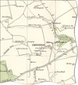
Chryston is a village in the central belt
of Scotland
in the county of North Lanarkshire
. Founded by James Burns Pollock, It is north of the main trunk road between Glasgow
and Stirling
(A80
).
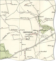 The village lies north of Muirhead
, seven miles east of Glasgow - the exact boundary between the two villages is difficult to find. Geographically, Moodiesburn
is often included in the Chryston district (Devro
headquarters, located in Moodiesburn, has Chryston as its official address); as with Muirhead, children born of Moodiesburn citizens have Chryston as their birth district on their birth certificate
.
Chryston Parish Church serves the villages of Chryston, Moodiesburn and Muirhead and has churches in Chryston and Moodiesburn.
On Friday 18 September, 1959, 47 miners lost their lives in the Auchengeich mining disaster at nearby Auchengeich Colliery.
Chryston High School
is a six-year non-denominational secondary school
situated on Lindsaybeg Road.
Central Belt
The Central Belt of Scotland is a common term used to describe the area of highest population density within Scotland. Despite the name, it is not geographically central but is nevertheless situated at the 'waist' of Scotland on a conventional map and the term 'central' is used in many local...
of Scotland
Scotland
Scotland is a country that is part of the United Kingdom. Occupying the northern third of the island of Great Britain, it shares a border with England to the south and is bounded by the North Sea to the east, the Atlantic Ocean to the north and west, and the North Channel and Irish Sea to the...
in the county of North Lanarkshire
North Lanarkshire
North Lanarkshire is one of 32 council areas in Scotland. It borders onto the northeast of the City of Glasgow and contains much of Glasgow's suburbs and commuter towns and villages. It also borders Stirling, Falkirk, East Dunbartonshire, West Lothian and South Lanarkshire...
. Founded by James Burns Pollock, It is north of the main trunk road between Glasgow
Glasgow
Glasgow is the largest city in Scotland and third most populous in the United Kingdom. The city is situated on the River Clyde in the country's west central lowlands...
and Stirling
Stirling
Stirling is a city and former ancient burgh in Scotland, and is at the heart of the wider Stirling council area. The city is clustered around a large fortress and medieval old-town beside the River Forth...
(A80
A80 road
The A80 is a road in Scotland, running from the A8 to Moodiesburn, north east of Glasgow. Prior to the M80 opening, the A80 was one of Scotland's busiest trunk roads.-Original Route:The A80 was once the main route from Glasgow to Stirling...
).
Muirhead
Muirhead is a small suburb about 7 miles North-East of Glasgow city centre. Nearby villages and towns include Chryston, Stepps, Lenzie, Garnkirk and Gartcosh....
, seven miles east of Glasgow - the exact boundary between the two villages is difficult to find. Geographically, Moodiesburn
Moodiesburn
Moodiesburn is a residential suburb located 8 miles north-east of Glasgow city centre, in the North Lanarkshire council area of Scotland. It is situated on the A80 road, between Stepps and Cumbernauld.-Landmarks:...
is often included in the Chryston district (Devro
Devro
Devro plc is a multinational company based in Moodiesburn, Chryston, Scotland which manufactures and distributes goods derived from collagen, principally sausage casings, a product in which it is the world leader. The firm also produces films, casings and other specialised collagen products for use...
headquarters, located in Moodiesburn, has Chryston as its official address); as with Muirhead, children born of Moodiesburn citizens have Chryston as their birth district on their birth certificate
Birth certificate
A birth certificate is a vital record that documents the birth of a child. The term "birth certificate" can refer to either the original document certifying the circumstances of the birth or to a certified copy of or representation of the ensuing registration of that birth...
.
Chryston Parish Church serves the villages of Chryston, Moodiesburn and Muirhead and has churches in Chryston and Moodiesburn.
On Friday 18 September, 1959, 47 miners lost their lives in the Auchengeich mining disaster at nearby Auchengeich Colliery.
Chryston High School
Chryston High School
Chryston High School is a six-year non-denominational secondary school situated in Chryston, North Lanarkshire, Scotland.The school plays an important role in the community with the students assisting with local organisations...
is a six-year non-denominational secondary school
Secondary school
Secondary school is a term used to describe an educational institution where the final stage of schooling, known as secondary education and usually compulsory up to a specified age, takes place...
situated on Lindsaybeg Road.