
Chocorua River
Encyclopedia
River
A river is a natural watercourse, usually freshwater, flowing towards an ocean, a lake, a sea, or another river. In a few cases, a river simply flows into the ground or dries up completely before reaching another body of water. Small rivers may also be called by several other names, including...
located in eastern New Hampshire
New Hampshire
New Hampshire is a state in the New England region of the northeastern United States of America. The state was named after the southern English county of Hampshire. It is bordered by Massachusetts to the south, Vermont to the west, Maine and the Atlantic Ocean to the east, and the Canadian...
in the United States
United States
The United States of America is a federal constitutional republic comprising fifty states and a federal district...
. It is a tributary
Tributary
A tributary or affluent is a stream or river that flows into a main stem river or a lake. A tributary does not flow directly into a sea or ocean...
of the Bearcamp River
Bearcamp River
The Bearcamp River is a 26.3 mile long river at the southern edge of the White Mountains in New Hampshire, the United States. It is the largest tributary of Ossipee Lake, part of the Saco River watershed leading to the Atlantic Ocean....
, part of the Ossipee Lake
Ossipee Lake
Ossipee Lake is located in Carroll County in eastern New Hampshire, in the communities of Ossipee and Freedom. At 3,245 acres, it is the sixth-largest lake located entirely in New Hampshire. The lake is fed by the West Branch , the Bearcamp and Lovell rivers , and the Pine River...
/ Saco River
Saco River
The Saco River is a river in northeastern New Hampshire and southwestern Maine in the United States. It drains a rural area of of forests and farmlands west and southwest of Portland, emptying into the Atlantic Ocean at Saco Bay, from its source. It supplies drinking water to roughly 250,000...
watershed
Drainage basin
A drainage basin is an extent or an area of land where surface water from rain and melting snow or ice converges to a single point, usually the exit of the basin, where the waters join another waterbody, such as a river, lake, reservoir, estuary, wetland, sea, or ocean...
leading to the Atlantic Ocean
Atlantic Ocean
The Atlantic Ocean is the second-largest of the world's oceanic divisions. With a total area of about , it covers approximately 20% of the Earth's surface and about 26% of its water surface area...
.
The Chocorua River rises on the eastern slopes of Mount Chocorua
Mount Chocorua
Mount Chocorua is a summit in the White Mountains of New Hampshire. At an elevation of it is the easternmost peak of the Sandwich Range....
, a prominent rocky knob at the southeast margin of the White Mountains
White Mountains (New Hampshire)
The White Mountains are a mountain range covering about a quarter of the state of New Hampshire and a small portion of western Maine in the United States. Part of the Appalachian Mountains, they are considered the most rugged mountains in New England...
. The river flows south into lowlands at the base of the mountain and arrives at Chocorua Lake
Chocorua Lake
Chocorua Lake is a picturesque lake in northeast New Hampshire with commanding views of the summit of Mount Chocorua. It is approximately 1.1 miles long with a maximum width of 3,500 ft , covering 222 acres , with a maximum depth of 27 feet .The lake is most noted for its serene setting...
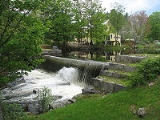
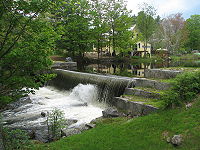
, noted for its outstanding view of Mount Chocorua. Beyond the lake, the river flows south to the village of Chocorua
Chocorua, New Hampshire
Chocorua is a village within the town of Tamworth in Carroll County, New Hampshire, United States. It is located in the general area where Routes 16 and 113 meet, south of Mount Chocorua and Chocorua Lake....
with a picturesque mill dam, then continues into the flat, sandy Ossipee Lake region, reaching the Bearcamp River at West Ossipee
Ossipee, New Hampshire
Ossipee is a town in Carroll County, New Hampshire, United States. The population was 4,345 at the 2010 census. It is the county seat of Carroll County...
.
New Hampshire Route 16
New Hampshire Route 16
New Hampshire Route 16 is a long north–south highway in the U.S. state of New Hampshire. Much of its length is close to the border with Maine. NH 16 is the main route from the Seacoast region north to the Lakes Region and the White Mountains. The section from Portsmouth to Milton is a...
parallels the Chocorua River for most of its length.