Bearcamp River
Encyclopedia
River
A river is a natural watercourse, usually freshwater, flowing towards an ocean, a lake, a sea, or another river. In a few cases, a river simply flows into the ground or dries up completely before reaching another body of water. Small rivers may also be called by several other names, including...
at the southern edge of the White Mountains
White Mountains (New Hampshire)
The White Mountains are a mountain range covering about a quarter of the state of New Hampshire and a small portion of western Maine in the United States. Part of the Appalachian Mountains, they are considered the most rugged mountains in New England...
in New Hampshire
New Hampshire
New Hampshire is a state in the New England region of the northeastern United States of America. The state was named after the southern English county of Hampshire. It is bordered by Massachusetts to the south, Vermont to the west, Maine and the Atlantic Ocean to the east, and the Canadian...
, the United States
United States
The United States of America is a federal constitutional republic comprising fifty states and a federal district...
. It is the largest tributary
Tributary
A tributary or affluent is a stream or river that flows into a main stem river or a lake. A tributary does not flow directly into a sea or ocean...
of Ossipee Lake
Ossipee Lake
Ossipee Lake is located in Carroll County in eastern New Hampshire, in the communities of Ossipee and Freedom. At 3,245 acres, it is the sixth-largest lake located entirely in New Hampshire. The lake is fed by the West Branch , the Bearcamp and Lovell rivers , and the Pine River...
, part of the Saco River
Saco River
The Saco River is a river in northeastern New Hampshire and southwestern Maine in the United States. It drains a rural area of of forests and farmlands west and southwest of Portland, emptying into the Atlantic Ocean at Saco Bay, from its source. It supplies drinking water to roughly 250,000...
watershed
Drainage basin
A drainage basin is an extent or an area of land where surface water from rain and melting snow or ice converges to a single point, usually the exit of the basin, where the waters join another waterbody, such as a river, lake, reservoir, estuary, wetland, sea, or ocean...
leading to the Atlantic Ocean
Atlantic Ocean
The Atlantic Ocean is the second-largest of the world's oceanic divisions. With a total area of about , it covers approximately 20% of the Earth's surface and about 26% of its water surface area...
.
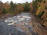
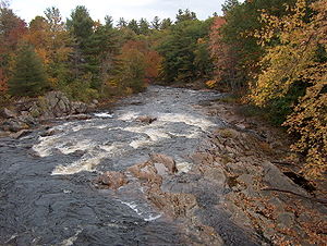
The Bearcamp River rises in Sandwich Notch, at the northeast end of the Squam Mountain Range and the western end of the Sandwich Range
Sandwich Range
The Sandwich Range is located in the White Mountains of New Hampshire in the United States, north of the Lakes Region and south of the Kancamagus Highway...
, in the town of Sandwich, New Hampshire
Sandwich, New Hampshire
Sandwich is a town in Carroll County, New Hampshire, United States. The population was 1,326 at the 2010 census. Sandwich includes the villages of Center Sandwich and North Sandwich...
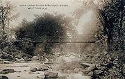
. It flows to the southeast, dropping over Beede Falls, and quickly reaches the lowlands at the base of the White Mountains. The river flows east through Sandwich, entering Tamworth
Tamworth, New Hampshire
Tamworth is a town in Carroll County, New Hampshire, United States. The population was 2,856 at the 2010 census. Tamworth includes the villages of Chocorua, South Tamworth, Wonalancet, and Whittier. The White Mountain National Forest is to the north...
at the juncture of the Cold River
Cold River (Bearcamp River)
The Cold River is an 11.9 mile long river located in the White Mountains of New Hampshire in the United States. It is a tributary of the Bearcamp River, part of the Ossipee River and Saco River watersheds...
. Passing the villages of South Tamworth and Whittier, the river nears the base of the Ossipee Mountains
Ossipee Mountains
The Ossipee Mountains are located just south of the White Mountains of New Hampshire, United States. Mount Shaw, at , is the highest point in the range.-Geology and physiography:...
to the south. It passes the village of West Ossipee
Ossipee, New Hampshire
Ossipee is a town in Carroll County, New Hampshire, United States. The population was 4,345 at the 2010 census. It is the county seat of Carroll County...
and enters Ossipee Lake after flowing through a small delta
River delta
A delta is a landform that is formed at the mouth of a river where that river flows into an ocean, sea, estuary, lake, reservoir, flat arid area, or another river. Deltas are formed from the deposition of the sediment carried by the river as the flow leaves the mouth of the river...
.
New Hampshire Route 25
New Hampshire Route 25
New Hampshire Route 25 is a long east–west state highway in New Hampshire. It runs completely across the state from Vermont to Maine.The western terminus of Route 25 is at the Vermont state line on the Connecticut River in Piermont, where the road continues west as Vermont Route 25...
follows the river through Tamworth to West Ossipee.