
Chirpan Peak
Encyclopedia
Bowles Ridge
Bowles Ridge is the central ridge of eastern Livingston Island. The ridge extends 6.5 km in the east-west direction and is 1.5 km wide. The summit of the ridge is Mount Bowles which rises to 822m and is located 9.77 km northwest of Great Needle Peak, 6.08 km north by west of...
on Livingston Island in the South Shetland Islands
South Shetland Islands
The South Shetland Islands are a group of Antarctic islands, lying about north of the Antarctic Peninsula, with a total area of . By the Antarctic Treaty of 1959, the Islands' sovereignty is neither recognized nor disputed by the signatories and they are free for use by any signatory for...
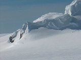
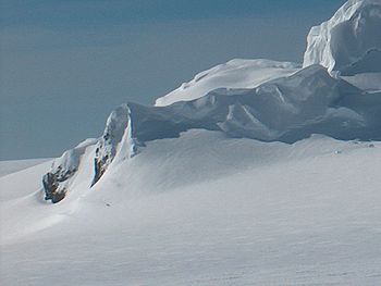
, Antarctica overlooking Perunika Glacier
Perunika Glacier
Perunika Glacier is an 8 km long and 3 km wide roughly crescent-shaped glacier in eastern Livingston Island in the South Shetland Islands, Antarctica....
to the west and south. The peak is named after the town of Chirpan
Chirpan
Chirpan is a town on the Tekirska River in Stara Zagora Province, South-central Bulgaria. It is the administrative centre of the homonymous Chirpan Municipality. As of December 2009, the town has a population of 16,355 inhabitants....
in southern Bulgaria.
Location
The peak is located at 62°36′53.5"S 60°13′34"W which is 1.23 km west of the summit Mount BowlesMount Bowles
Mount Bowles is an ice-covered mountain of elevation 822 m, the summit of Bowles Ridge in eastern Livingston Island, South Shetland Islands. Situated 3 mi north of Mount Friesland to which it is linked by Wörner Gap. Coordinates and elevation given according to 2003 Australian GPS survey...
, 1.01 km south-southwest of Hemus Peak
Hemus Peak
Hemus Peak is an ice-covered peak rising to 636 m off the northwest extremity of Bowles Ridge in eastern Livingston Island. The feature is breast-shaped, 850 m long in east-west direction and 550 m wide, and overlooks Kaliakra Glacier to the northeast and Perunika Glacier to the southwest...
, 2.85 km east-northeast of Rezen Knoll
Rezen Knoll
Rezen Knoll is a knoll rising to 433 m in eastern Livingston Island in the South Shetland Islands, Antarctica. The knoll is bounded to the east, north and west by Perunika Glacier, and linked to Burdick Ridge by Rezen Saddle. The feature is 250 m wide, extending 500 m in east-west direction....
and 1.12 km northwest of Svoge Knoll
Svoge Knoll
Svoge Knoll is an ice-covered peak rising to 560 m in Bowles Ridge, Livingston Island in the South Shetland Islands, Antarctica...
.
Bulgarian mapping in 2005 and 2009 from the Tangra 2004/05
Tangra 2004/05
The Tangra 2004/05 Expedition was commissioned by the Antarctic Place-names Commission at the Ministry of Foreign Affairs of Bulgaria, managed by the Manfred Wörner Foundation, and supported by the Bulgarian Antarctic Institute, the Institute of Mathematics and Informatics at the Bulgarian Academy...
topographic survey.
Maps
- L.L. Ivanov et al. Antarctica: Livingston Island and Greenwich Island, South Shetland Islands. Scale 1:100000 topographic map. Sofia: Antarctic Place-names Commission of Bulgaria, 2005.
- L.L. Ivanov. Antarctica: Livingston Island and Greenwich, Robert, Snow and Smith Islands. Scale 1:120000 topographic map. Troyan: Manfred Wörner Foundation, 2009. ISBN 978-954-92032-6-4