

Chinaman's Hat (Port Phillip)
Encyclopedia
Hauling-out
Hauling-out is the behaviour associated with pinnipeds , of temporarily leaving the water between periods of foraging activity for sites on land or ice...
for local Brown fur seals, in the South Channel of Port Phillip
Port Phillip
Port Phillip Port Phillip Port Phillip (also commonly referred to as Port Phillip Bay or (locally) just The Bay, is a large bay in southern Victoria, Australia; it is the location of Melbourne. Geographically, the bay covers and the shore stretches roughly . Although it is extremely shallow for...
, Victoria
Victoria (Australia)
Victoria is the second most populous state in Australia. Geographically the smallest mainland state, Victoria is bordered by New South Wales, South Australia, and Tasmania on Boundary Islet to the north, west and south respectively....
in the Mornington Peninsula Shire
Shire of Mornington Peninsula
The Shire of Mornington Peninsula is a Local Government Area in Victoria, Australia. It is located to the south of the city of Melbourne on the Mornington Peninsula. It has an area of 723 square kilometres...
, three kilometers ESE of Pope's Eye
Pope's Eye
Pope's Eye is the uncompleted foundation for an island fort intended to defend the entrance to Port Phillip in the state of Victoria, Australia. It is less than a kilometre south-west of the former Chinaman's Hat....
. With the latter it served as a navigation beacon at the Heads of the bay
The Rip
"The Rip", also known as "The Heads", is a dangerous stretch of water in Victoria, Australia, connecting Port Phillip and Bass Strait. It is the only entrance for shipping into Port Phillip and hence into Melbourne. Because of large tidal flows through the relatively narrow channel from the bay to...
.
History
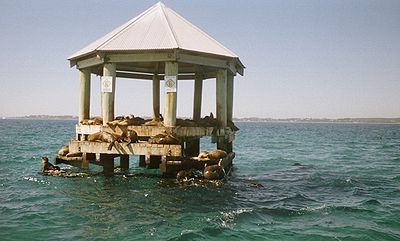
The term Chinaman's Hat is the local name once associated with the site of a former military structure, Station M, but now transferred to a new seal platform erected by Victoria's Park Authority in 2002.The postwar structure was built to replace a dilapidated military installation erected on a dolphin
Dolphin (structure)
A dolphin is a man-made marine structure that extends above the water level and is not connected to shore.Dolphins are usually installed to provide a fixed structure when it would be impractical to extend the shore to provide a dry access facility, for example, when ships are greater than the...
as part of the Port Phillip
Port Phillip
Port Phillip Port Phillip Port Phillip (also commonly referred to as Port Phillip Bay or (locally) just The Bay, is a large bay in southern Victoria, Australia; it is the location of Melbourne. Geographically, the bay covers and the shore stretches roughly . Although it is extremely shallow for...
bay defence system shortly before 1942. This earlier structure is often said to have supported an optical mount, or 'Magic Eye' which transmitted two Piezo
Piezo
"Piezo", derived from the Greek piezein, which means to squeeze or press, is a prefix used in:* Piezoelectricity* Piezoresistive effect* Piezometer* Piezo ignition* Piezoelectric sensor* Piezoelectric loudspeakers* Piezo Audio Amplifier...
electronic beams across the Rip
The Rip
"The Rip", also known as "The Heads", is a dangerous stretch of water in Victoria, Australia, connecting Port Phillip and Bass Strait. It is the only entrance for shipping into Port Phillip and hence into Melbourne. Because of large tidal flows through the relatively narrow channel from the bay to...
to a large mirror, and then to two reflectors, respectively Station P, and Station S, at the Heads of Point Lonsdale. Any break in transmission in such a system was designed to set off an alarm to signal the possible presence of enemy vessels. The mechanism apparently did not function as expected, and the equipment was removed two years later, in 1944. Some doubts, however, have been expressed regarding the existence of this interception system: the site certainly was equipped in wartime with underwater indicator loops
Anti-submarine indicator loop
An anti-submarine indicator loop was a submerged cable laid on the sea bed and used to detect the passage of enemy submarines. Developed by the Royal Navy during World War I, they were extensively used by the Allies during World War II to protect harbours against submarine attack.They worked as...
to detect submarines.
After it was abandoned, the dilapidated remains were used as a perch for both recreational fishing and as an anchorage. It rested on a circular concrete caisson
Caisson (engineering)
In geotechnical engineering, a caisson is a retaining, watertight structure used, for example, to work on the foundations of a bridge pier, for the construction of a concrete dam, or for the repair of ships. These are constructed such that the water can be pumped out, keeping the working...
base, roughly 7 metres in diameter, raised on a sandy shoal some 6 metres below the waterline.
Parks Victoria
Parks Victoria
-Department:Parks Victoria was established in December 1996 as a statutory authority, reporting to the Minister for Environment and Climate Change. The Parks Victoria Act 1998 makes Parks Victoria responsible for managing national parks, reserves and other land under the control of the state,...
was granted a permit in early 2002 to demolish the old structure after arguing that it posed a risk for small craft navigation and was devoid of heritage value
Cultural heritage
Cultural heritage is the legacy of physical artifacts and intangible attributes of a group or society that are inherited from past generations, maintained in the present and bestowed for the benefit of future generations...
. In the face of public protests, the Authority went ahead and built, at a cost of $A210,000, an expensive alternative platform which was quickly disparaged by critics at the time as a veritable 'Taj Mahal
Taj Mahal
The Taj Mahal is a white Marble mausoleum located in Agra, India. It was built by Mughal emperor Shah Jahan in memory of his third wife, Mumtaz Mahal...
for seals'. This new structure for the seal colony was grounded on a rectangular base and lies not far from the Mud Islands
Mud Islands
The Mud Islands reserve is located within Port Phillip, about 90 km south-west of Melbourne, Australia, lying 10 km inside Port Phillip Heads, 7 km north of Portsea and 9 km east of Queenscliff. The land area of about 50 ha is made up of three low-lying islands surrounding a shallow tidal 35 ha...
bird sanctuary. However, the seals refused to budge from their traditional, run-down landmark, and it was only after the authorities proceeded to demolish the old haul-out that they settled on the new platform. It is this new structure which now carries the name Chinaman's Hat.
The present structure is one of four 'haul outs' or resting sites in the bay, and is occupied by a bachelor community of the Australian Fur Seals. It is a popular destination for scuba divers and snorkelers. Visitors to the site are warned to keep their distance, since the seals can at times behave aggressively towards people who get too close.