
Cherryfield, Maine
Encyclopedia
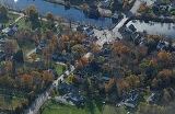
Cherryfield is a town
in Washington County
, Maine
, United States
on the Narraguagus River
. It was named for the wild cherries that once peppered the banks of the river. The population was 1,157 at the 2000 census. The town bills itself as the "Blueberry
Capital of the World". Roughly 75 acres (303,514.5 m²) on both sides of the river are a historic district on the National Register of Historic Places
known as the Cherryfield Historic District
. This district comprises a collection of period structures dating from c1750-1890. The town was first settled about 1760, and was originally part of Steuben
, Maine
.
, the town has a total area of 44.2 square miles (114.5 km²), of which, 43.7 square miles (113.2 km²) of it is land and 0.5 square miles (1.3 km²) of it (1.18%) is water. The town is home to two breeding pairs of bald eagles.
of 2000, there were 1,157 people, 493 households, and 317 families residing in the town. The population density
was 26.5 people per square mile (10.2/km²). There were 644 housing units at an average density of 14.7 per square mile (5.7/km²). The racial makeup of the town was 98.01% White, 0.09% African American, 0.69% Native American, 0.43% Asian, 0.17% from other races
, and 0.61% from two or more races. Hispanic or Latino of any race were 0.09% of the population.
There were 493 households out of which 27.4% had children under the age of 18 living with them, 51.7% were married couples
living together, 8.1% had a female householder with no husband present, and 35.5% were non-families. 30.6% of all households were made up of individuals and 17.2% had someone living alone who was 65 years of age or older. The average household size was 2.29 and the average family size was 2.85.
In the town the population was spread out with 22.5% under the age of 18, 5.3% from 18 to 24, 24.0% from 25 to 44, 27.5% from 45 to 64, and 20.7% who were 65 years of age or older. The median age was 44 years. For every 100 females there were 87.2 males. For every 100 females age 18 and over, there were 88.1 males.
The median income for a household in the town was $21,486, and the median income for a family was $31,016. Males had a median income of $26,058 versus $20,000 for females. The per capita income
for the town was $13,111. About 15.8% of families and 21.9% of the population were below the poverty line, including 24.6% of those under age 18 and 27.5% of those age 65 or over.
New England town
The New England town is the basic unit of local government in each of the six New England states. Without a direct counterpart in most other U.S. states, New England towns are conceptually similar to civil townships in other states, but are incorporated, possessing powers like cities in other...
in Washington County
Washington County, Maine
Washington County is a county located in the U.S. state of Maine. In 2010, its population was 32,856. Its county seat is Machias.Sometimes referred to as "Sunrise County" because it is the easternmost county in the United States, and it is often where the rising sun first shines on the 48...
, Maine
Maine
Maine is a state in the New England region of the northeastern United States, bordered by the Atlantic Ocean to the east and south, New Hampshire to the west, and the Canadian provinces of Quebec to the northwest and New Brunswick to the northeast. Maine is both the northernmost and easternmost...
, United States
United States
The United States of America is a federal constitutional republic comprising fifty states and a federal district...
on the Narraguagus River
Narraguagus River
The Narraguagus River is a river located in the U.S. state of Maine with its mouth in the Narraguagus Bay of the Gulf of Maine. It flows through the town of Cherryfield and was formerly well known for its sport fly fishing for Atlantic salmon. This was a traditional highlight of late spring with...
. It was named for the wild cherries that once peppered the banks of the river. The population was 1,157 at the 2000 census. The town bills itself as the "Blueberry
Blueberry
Blueberries are flowering plants of the genus Vaccinium with dark-blue berries and are perennial...
Capital of the World". Roughly 75 acres (303,514.5 m²) on both sides of the river are a historic district on the National Register of Historic Places
National Register of Historic Places
The National Register of Historic Places is the United States government's official list of districts, sites, buildings, structures, and objects deemed worthy of preservation...
known as the Cherryfield Historic District
Cherryfield Historic District
The Cherryfield Historic District is a historic area in Cherryfield, Maine. The district was entered in the National Register of Historic Places on October 1, 1990 by recommendation of the Maine Historic Preservation Commission and was approved by the Department of the Interior in Washington,...
. This district comprises a collection of period structures dating from c1750-1890. The town was first settled about 1760, and was originally part of Steuben
Steuben, Maine
Steuben is a town in Washington County, Maine, United States. Upon incorporation in 1795 it was named after Baron Frederick William Rudolph Gerald Augustus von Steuben, the Inspector General of the U.S. Army during the Revolutionary War...
, Maine
Maine
Maine is a state in the New England region of the northeastern United States, bordered by the Atlantic Ocean to the east and south, New Hampshire to the west, and the Canadian provinces of Quebec to the northwest and New Brunswick to the northeast. Maine is both the northernmost and easternmost...
.
Geography
According to the United States Census BureauUnited States Census Bureau
The United States Census Bureau is the government agency that is responsible for the United States Census. It also gathers other national demographic and economic data...
, the town has a total area of 44.2 square miles (114.5 km²), of which, 43.7 square miles (113.2 km²) of it is land and 0.5 square miles (1.3 km²) of it (1.18%) is water. The town is home to two breeding pairs of bald eagles.
Demographics
As of the censusCensus
A census is the procedure of systematically acquiring and recording information about the members of a given population. It is a regularly occurring and official count of a particular population. The term is used mostly in connection with national population and housing censuses; other common...
of 2000, there were 1,157 people, 493 households, and 317 families residing in the town. The population density
Population density
Population density is a measurement of population per unit area or unit volume. It is frequently applied to living organisms, and particularly to humans...
was 26.5 people per square mile (10.2/km²). There were 644 housing units at an average density of 14.7 per square mile (5.7/km²). The racial makeup of the town was 98.01% White, 0.09% African American, 0.69% Native American, 0.43% Asian, 0.17% from other races
Race (United States Census)
Race and ethnicity in the United States Census, as defined by the Federal Office of Management and Budget and the United States Census Bureau, are self-identification data items in which residents choose the race or races with which they most closely identify, and indicate whether or not they are...
, and 0.61% from two or more races. Hispanic or Latino of any race were 0.09% of the population.
There were 493 households out of which 27.4% had children under the age of 18 living with them, 51.7% were married couples
Marriage
Marriage is a social union or legal contract between people that creates kinship. It is an institution in which interpersonal relationships, usually intimate and sexual, are acknowledged in a variety of ways, depending on the culture or subculture in which it is found...
living together, 8.1% had a female householder with no husband present, and 35.5% were non-families. 30.6% of all households were made up of individuals and 17.2% had someone living alone who was 65 years of age or older. The average household size was 2.29 and the average family size was 2.85.
In the town the population was spread out with 22.5% under the age of 18, 5.3% from 18 to 24, 24.0% from 25 to 44, 27.5% from 45 to 64, and 20.7% who were 65 years of age or older. The median age was 44 years. For every 100 females there were 87.2 males. For every 100 females age 18 and over, there were 88.1 males.
The median income for a household in the town was $21,486, and the median income for a family was $31,016. Males had a median income of $26,058 versus $20,000 for females. The per capita income
Per capita income
Per capita income or income per person is a measure of mean income within an economic aggregate, such as a country or city. It is calculated by taking a measure of all sources of income in the aggregate and dividing it by the total population...
for the town was $13,111. About 15.8% of families and 21.9% of the population were below the poverty line, including 24.6% of those under age 18 and 27.5% of those age 65 or over.
Notable people
- Hiram BurnhamHiram BurnhamHiram Burnham was an officer in the Union Army who commanded a regiment and then a brigade in the Eastern Theater of the American Civil War...
,Civil War era general. - Carlton WilleyCarlton WilleyCarlton Francis Willey was an American professional baseball player who pitched eight seasons for the Milwaukee Braves and New York Mets of Major League Baseball...
, pitcher for the Braves and MetsNew York MetsThe New York Mets are a professional baseball team based in the borough of Queens in New York City, New York. They belong to Major League Baseball's National League East Division. One of baseball's first expansion teams, the Mets were founded in 1962 to replace New York's departed National League...
.
Economy
- Cherryfield Foods, blueberry processing company.
- Jasper Wyman & Son, blueberry processing company, the manufacturing plant is located in Cherryfield.