
.gif)
Centre Street Bridge (Newark)
Encyclopedia
Route 158 was a short state highway in Newark, New Jersey
and Harrison, New Jersey
in the counties of Essex
and Hudson
, which are located in the United States
. The Centre Street Bridge was first constructed in 1834 as a single-level railroad bridge. However, in 1911, almost eight decades later, a second, upper level was constructed for rapid transit
. In 1937, the Hudson and Manhattan Railroad, now part of the Port Authority Trans-Hudson
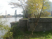
line, was realigned onto railroad tracks along New Jersey Route 21. The upper level of the bridge was abandoned for this purpose, and was later converted to roadway. At the western end in Newark it ran just south of Park Place, beginning at Center Street. The route headed eastward, crossing over Route 21 and the Passaic River before entering Harrison, where it terminated at Second Street north of New Jersey Railroad Avenue.
Eventually, the upper level roadway was designated by the New Jersey State Highway Department as Route 25AD. A spur of the recently designated State Highway Route 25A, the highway department made the roadway a suffixed spur of the highway because of the close proximity. Route 25A later became New Jersey Route 58
and is now an alignment of Interstate 280
. The designation remained intact until the 1953 New Jersey state highway renumbering
on January 1, 1953, when it was changed to New Jersey Route 158. Route 158 appeared on the state map for New Jersey
until up to 1960, when it disappeared from the maps as a public highway. After 1960, Route 158 did not appear on maps, and the bridge was torn down around 1979.
) in the city of Newark
. The route went up in elevation, paralleling Park Place until crossing New Jersey Route 21 (the McCarter Highway). The highway continued eastward, crossing the last patch of land between 21 and the river before heading onto the swing bridge. Route 158 crossed as a two-lane bridge into Harrison
. The route continued onto land just north of New Jersey Railroad Avenue, where it turned northward along First Street. Route 158 turned eastward onto Essex Street, with the right-of-way ending at Second Street, where the designation ended as well.
 The lower level of the Centre Street Bridge, a continuation of Centre Street in Newark, was first constructed for the New Jersey Railroad, which later became part of the Pennsylvania Railroad
. On September 15, 1834, the bridge was first opened on a single level for trains. A cutoff around the bridge opened in 1870, and the old route became the Centre Street Branch of the New Jersey Railroad, later being cut from the main line to the south. On March 1, 1901, a Pennsylvania Railroad train derailed its rear cars on the bridge at 10:23 that evening. When it derailed, the rear cars were dragged for 100 yards across the trestle. The train, which consisted of a locomotive and five other cars, had just left the Centre Street station, when it derailed. The bridge had no guard rails at the time, and the rails hung over the bridge. The cars were disconnected, and the passengers continued to Jersey City
. However, the reason for the cars jumping the rails were not known.
In July 1901, the states of New Jersey and New York proposed improvements to several local bridges to the United States Congress
. The proposal asked for $45,000 (1901 USD) in improvements of dredging and maintaining the channel of the Passaic River
below the bridge. On April 2, 1911, almost ten years after the proposed improvements, construction began on a new high-speed line in Newark along the Hudson and Manhattan Railroad. It was proposed to be completed by the end of the summer in that year, to help commuters to New York City
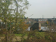
. The same proposal asked for authorization of a proposal for subways in the city by the state of New Jersey. The bridge at the time was made of steel with concrete flooring and pavement. The upper-level was to have a clearance of 18 feet (5.5 m) and there was to be a 230 feet (70.1 m) long drawbridge in the center. The upper level was to be used by the new passenger line and the lower level was to be used for the freight line of the Pennsylvania Railroad.
The new high-speed line and double-decker Centre Street Bridge was completed on November 18, 1911. The last rail that had to be constructed was completed that very day for the eighty-six Newark-bound trains to run in each direction of that line. The drawbridge's only use was for the freight line that was to go along the lower level of the bridge. As proposed, the upper level was given to the line. On November 25, 1911, the bridge re-opened once again as a double level bridge. connecting to the H&M to Park Place
.
On June 27, 1937, a proposal was made by the city of Newark and the counties of Hudson and Essex to convert the upper level of the span to a roadway after proposing that the Hudson and Manhattan Railroad, now the Port Authority Trans-Hudson
, to be moved onto tracks that paralleled New Jersey Route 21, which was assigned in 1927. Later that year, construction was completed, and the upper level span was officially a road for automobiles.
, and later Interstate 280
to the south in the proximity of the bridge.
 The state highway department a few years later then designated the alignment of the upper level span of the bridge as New Jersey State Highway Route 25A-D, which was a suffixed spur of Route 25A. Even with the designation, State Highway Route 25A-D did not connect to its parent or grandparent routes. However, unlike Route 25A, Route 25A-D did not appear in the state laws. The route remained intact along the bridge from New Jersey Route 21 and Center Street in Newark to Second Street in Harrison until January 1, 1953, when the state highway department completed a second renumbering
of state highways in New Jersey.
After the renumbering of state highways, State Highway Route 25A was renumbered as New Jersey Route 58, which caused the bridge, still in the proximity of NJ 58, to be renumbered as New Jersey Route 158, a prefixed spur. Route 158 appeared in maps along the Centre Street Bridge as a publicly used highway until 1960, when it disappeared from the maps. Route 158's official decommissioning date is currently unknown, but the Centre Street Bridge was torn down around 1979.
Newark, New Jersey
Newark is the largest city in the American state of New Jersey, and the seat of Essex County. As of the 2010 United States Census, Newark had a population of 277,140, maintaining its status as the largest municipality in New Jersey. It is the 68th largest city in the U.S...
and Harrison, New Jersey
Harrison, New Jersey
Harrison is a town in Hudson County, New Jersey, United States. As of the 2010 United States Census, the town's population was 13,620. The town is a suburb of the nearby city of Newark, New Jersey.-Geography:Harrison is located at ....
in the counties of Essex
Essex County, New Jersey
Essex County is a county located in the northeastern part of the U.S. state of New Jersey. As of the United States 2010 Census, the population was 783,969, ranking it third in the state after Bergen County and Middlesex County; Essex County's population has declined from 786,147 as of the bureau's...
and Hudson
Hudson County, New Jersey
Hudson County is the smallest county in New Jersey and one of the most densely populated in United States. It takes its name from the Hudson River, which creates part of its eastern border. Part of the New York metropolitan area, its county seat and largest city is Jersey City.- Municipalities...
, which are located in the United States
United States
The United States of America is a federal constitutional republic comprising fifty states and a federal district...
. The Centre Street Bridge was first constructed in 1834 as a single-level railroad bridge. However, in 1911, almost eight decades later, a second, upper level was constructed for rapid transit
Rapid transit
A rapid transit, underground, subway, elevated railway, metro or metropolitan railway system is an electric passenger railway in an urban area with a high capacity and frequency, and grade separation from other traffic. Rapid transit systems are typically located either in underground tunnels or on...
. In 1937, the Hudson and Manhattan Railroad, now part of the Port Authority Trans-Hudson
Port Authority Trans-Hudson
PATH, derived from Port Authority Trans-Hudson, is a rapid transit railroad linking Manhattan, New York City with Newark, Harrison, Hoboken and Jersey City in metropolitan northern New Jersey...
line, was realigned onto railroad tracks along New Jersey Route 21. The upper level of the bridge was abandoned for this purpose, and was later converted to roadway. At the western end in Newark it ran just south of Park Place, beginning at Center Street. The route headed eastward, crossing over Route 21 and the Passaic River before entering Harrison, where it terminated at Second Street north of New Jersey Railroad Avenue.
Eventually, the upper level roadway was designated by the New Jersey State Highway Department as Route 25AD. A spur of the recently designated State Highway Route 25A, the highway department made the roadway a suffixed spur of the highway because of the close proximity. Route 25A later became New Jersey Route 58
New Jersey Route 58
Route 58 is a former state highway in the city of Newark, New Jersey and nearby borough of Harrison, New Jersey. The highway ran from Orange and Hecker Streets in Newark, eastbound as a four-lane freeway across the William A. Stickel Memorial Bridge to Harrison, where it terminated at an...
and is now an alignment of Interstate 280
Interstate 280 (New Jersey)
Interstate 280 is a Interstate Highway in the U.S. state of New Jersey. It provides a spur from I-80 in Parsippany-Troy Hills, Morris County to Newark, and I-95 Interstate 280 (abbreviated I-280) is a Interstate Highway in the U.S. state of New Jersey. It provides a spur from I-80 in...
. The designation remained intact until the 1953 New Jersey state highway renumbering
1953 New Jersey state highway renumbering
On January 1, 1953, the New Jersey Department of Transportation renumbered many of the State Routes. A few rules were followed in deciding what to renumber:...
on January 1, 1953, when it was changed to New Jersey Route 158. Route 158 appeared on the state map for New Jersey
New Jersey
New Jersey is a state in the Northeastern and Middle Atlantic regions of the United States. , its population was 8,791,894. It is bordered on the north and east by the state of New York, on the southeast and south by the Atlantic Ocean, on the west by Pennsylvania and on the southwest by Delaware...
until up to 1960, when it disappeared from the maps as a public highway. After 1960, Route 158 did not appear on maps, and the bridge was torn down around 1979.
Route description
Route 158 began at an intersection with Park Place and Center Street (County Route 508County Route 508 (New Jersey)
County Route 508 is a county highway in the U.S. state of New Jersey. The highway extends 16.14 miles from Mount Pleasant Avenue in Livingston to Belleville Turnpike in Kearny.-Essex County:...
) in the city of Newark
Newark, New Jersey
Newark is the largest city in the American state of New Jersey, and the seat of Essex County. As of the 2010 United States Census, Newark had a population of 277,140, maintaining its status as the largest municipality in New Jersey. It is the 68th largest city in the U.S...
. The route went up in elevation, paralleling Park Place until crossing New Jersey Route 21 (the McCarter Highway). The highway continued eastward, crossing the last patch of land between 21 and the river before heading onto the swing bridge. Route 158 crossed as a two-lane bridge into Harrison
Harrison, New Jersey
Harrison is a town in Hudson County, New Jersey, United States. As of the 2010 United States Census, the town's population was 13,620. The town is a suburb of the nearby city of Newark, New Jersey.-Geography:Harrison is located at ....
. The route continued onto land just north of New Jersey Railroad Avenue, where it turned northward along First Street. Route 158 turned eastward onto Essex Street, with the right-of-way ending at Second Street, where the designation ended as well.
Railroad bridge
Pennsylvania Railroad
The Pennsylvania Railroad was an American Class I railroad, founded in 1846. Commonly referred to as the "Pennsy", the PRR was headquartered in Philadelphia, Pennsylvania....
. On September 15, 1834, the bridge was first opened on a single level for trains. A cutoff around the bridge opened in 1870, and the old route became the Centre Street Branch of the New Jersey Railroad, later being cut from the main line to the south. On March 1, 1901, a Pennsylvania Railroad train derailed its rear cars on the bridge at 10:23 that evening. When it derailed, the rear cars were dragged for 100 yards across the trestle. The train, which consisted of a locomotive and five other cars, had just left the Centre Street station, when it derailed. The bridge had no guard rails at the time, and the rails hung over the bridge. The cars were disconnected, and the passengers continued to Jersey City
Jersey City, New Jersey
Jersey City is the seat of Hudson County, New Jersey, United States.Part of the New York metropolitan area, Jersey City lies between the Hudson River and Upper New York Bay across from Lower Manhattan and the Hackensack River and Newark Bay...
. However, the reason for the cars jumping the rails were not known.
In July 1901, the states of New Jersey and New York proposed improvements to several local bridges to the United States Congress
United States Congress
The United States Congress is the bicameral legislature of the federal government of the United States, consisting of the Senate and the House of Representatives. The Congress meets in the United States Capitol in Washington, D.C....
. The proposal asked for $45,000 (1901 USD) in improvements of dredging and maintaining the channel of the Passaic River
Passaic River
The Passaic River is a mature surface river, approximately 80 mi long, in northern New Jersey in the United States. The river in its upper course flows in a highly circuitous route, meandering through the swamp lowlands between the ridge hills of rural and suburban northern New Jersey,...
below the bridge. On April 2, 1911, almost ten years after the proposed improvements, construction began on a new high-speed line in Newark along the Hudson and Manhattan Railroad. It was proposed to be completed by the end of the summer in that year, to help commuters to New York City
New York City
New York is the most populous city in the United States and the center of the New York Metropolitan Area, one of the most populous metropolitan areas in the world. New York exerts a significant impact upon global commerce, finance, media, art, fashion, research, technology, education, and...
. The same proposal asked for authorization of a proposal for subways in the city by the state of New Jersey. The bridge at the time was made of steel with concrete flooring and pavement. The upper-level was to have a clearance of 18 feet (5.5 m) and there was to be a 230 feet (70.1 m) long drawbridge in the center. The upper level was to be used by the new passenger line and the lower level was to be used for the freight line of the Pennsylvania Railroad.
The new high-speed line and double-decker Centre Street Bridge was completed on November 18, 1911. The last rail that had to be constructed was completed that very day for the eighty-six Newark-bound trains to run in each direction of that line. The drawbridge's only use was for the freight line that was to go along the lower level of the bridge. As proposed, the upper level was given to the line. On November 25, 1911, the bridge re-opened once again as a double level bridge. connecting to the H&M to Park Place
Park Place (H&M station)
Park Place was a terminal of the Hudson and Manhattan Railroad located at the intersection of Park Place and Center Street in Newark, New Jersey, across the street from Military Park. The terminal opened on November 26, 1911, after the H&M extended its line westward from Grove Street in Jersey...
.
On June 27, 1937, a proposal was made by the city of Newark and the counties of Hudson and Essex to convert the upper level of the span to a roadway after proposing that the Hudson and Manhattan Railroad, now the Port Authority Trans-Hudson
Port Authority Trans-Hudson
PATH, derived from Port Authority Trans-Hudson, is a rapid transit railroad linking Manhattan, New York City with Newark, Harrison, Hoboken and Jersey City in metropolitan northern New Jersey...
, to be moved onto tracks that paralleled New Jersey Route 21, which was assigned in 1927. Later that year, construction was completed, and the upper level span was officially a road for automobiles.
Road bridge
The Centre Street Bridge was later designated as a state highway under the public highway system. The New Jersey State Highway Department had recently designated New Jersey State Highway Route 25A, which became New Jersey Route 58New Jersey Route 58
Route 58 is a former state highway in the city of Newark, New Jersey and nearby borough of Harrison, New Jersey. The highway ran from Orange and Hecker Streets in Newark, eastbound as a four-lane freeway across the William A. Stickel Memorial Bridge to Harrison, where it terminated at an...
, and later Interstate 280
Interstate 280 (New Jersey)
Interstate 280 is a Interstate Highway in the U.S. state of New Jersey. It provides a spur from I-80 in Parsippany-Troy Hills, Morris County to Newark, and I-95 Interstate 280 (abbreviated I-280) is a Interstate Highway in the U.S. state of New Jersey. It provides a spur from I-80 in...
to the south in the proximity of the bridge.
1953 New Jersey state highway renumbering
On January 1, 1953, the New Jersey Department of Transportation renumbered many of the State Routes. A few rules were followed in deciding what to renumber:...
of state highways in New Jersey.
After the renumbering of state highways, State Highway Route 25A was renumbered as New Jersey Route 58, which caused the bridge, still in the proximity of NJ 58, to be renumbered as New Jersey Route 158, a prefixed spur. Route 158 appeared in maps along the Centre Street Bridge as a publicly used highway until 1960, when it disappeared from the maps. Route 158's official decommissioning date is currently unknown, but the Centre Street Bridge was torn down around 1979.
Major intersections
See also
- New Jersey Route 58New Jersey Route 58Route 58 is a former state highway in the city of Newark, New Jersey and nearby borough of Harrison, New Jersey. The highway ran from Orange and Hecker Streets in Newark, eastbound as a four-lane freeway across the William A. Stickel Memorial Bridge to Harrison, where it terminated at an...