

Central Province (Kenya)
Encyclopedia
Kenya
Kenya , officially known as the Republic of Kenya, is a country in East Africa that lies on the equator, with the Indian Ocean to its south-east...
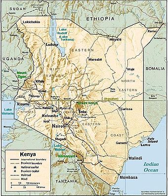
's Central Province covers an area of 13,191 km² and is located to north of Nairobi
Nairobi
Nairobi is the capital and largest city of Kenya. The city and its surrounding area also forms the Nairobi County. The name "Nairobi" comes from the Maasai phrase Enkare Nyirobi, which translates to "the place of cool waters". However, it is popularly known as the "Green City in the Sun" and is...
and west of Mt. Kenya(see maps). The province had 4,383,743 inhabitants according to the 2009 census. The provincial capital is Nyeri
Nyeri
Nyeri is a town in situated in the Central Highlands of Kenya Kenya, which was the administrative headquarters of the country's former Central Province...
.
Central Province is the ancestral home of the Gikuyu community.
Climate
The climate of Central Province is generally cooler than that of the rest of Kenya, due to the region's higher altitude. Rainfall is fairly reliable, falling in two seasons, one from early March to May (the long rains) and a second during October and November (the short rains).General information
Central Province is a key producer of coffee, one of Kenya's key exports. Much of Kenya's dairy industry is also based in this province. The province's headquarters are in NyeriNyeri
Nyeri is a town in situated in the Central Highlands of Kenya Kenya, which was the administrative headquarters of the country's former Central Province...
. Central Province was divided into seven districts (wilaya'at
Wilayah
A wilāyah or vilâyet , or vilayat in Urdu and Turkish, is an administrative division, usually translated as "province", rarely as "governorate". The word comes from the Arabic "w-l-y", "to govern": a wāli — "governor" — governs a wilayah, "that which is governed"...
) until 2007. The general dressing style is trousers and shirts for men and dresses or skirts for the women. The people usually have scraps of cloth tied to their foreheads during the hot days.:
| District | Population | Capital |
|---|---|---|
| Nyandarua Nyandarua District Nyandarua District is an administrative district in the Central Province of Kenya. Its capital town is Ol Kalou. Formerly the capital was Nyahururu, but it is now part of the Laikipia District. Nyandarua District has population of 479,902 and an area of 3,304 km²... |
479,902 | Ol Kalou Ol Kalou Ol Kalou is a town in Kenya. It is the headquarters of Nyandarua District of Central Province. It is located west of Aberdare range and 40 kilometres east of Nakuru. Ol Kalou is connected by road to Gilgil, Nyahururu and Nakuru... * |
| Nyeri Nyeri District Nyeri District is a district in the Central Province of Kenya. Its headquarters is in Nyeri town. It has a population of 661,156 and an area of 3,356 km².The district is located on the southwest flank of Mount Kenya... |
661,156 | Nyeri Nyeri Nyeri is a town in situated in the Central Highlands of Kenya Kenya, which was the administrative headquarters of the country's former Central Province... |
| Kirinyaga Kirinyaga District Kirinyaga District is an administrative district in the Central Province of Kenya. Its capital town is Kerugoya. The district has a population of 457,105 and an area of 1,478 km² .The district has four constituencies:*Mwea Constituency... |
457,105 | Kerugoya Kerugoya Kerugoya is a town in Kenya. It is the capital of Kirinyaga District of Central Province. Kerugoya is located 10 kilometres east of Karatina and 40 kilometres west of Embu.... |
| Maragua Maragua District Maragua District is one of the seventy-one districts of Kenya, located in the Central Province. Its capital is the town of Maragua. Maragua District has a population of 387,969 and an area of 868 km²... |
387,969 | Maragua Maragua Maragua is a town in the Central Province of Kenya. It is the capital of the Maragua District. The town is located along Thika–Sagana road just 10 km south of Murang'a. Maragua town has an urban population of 4,286 and a total population of 27,384 . Norwegian-Kenyan singer Stella Mwangi was... |
| Murang'a Muranga District Murang'a is one of the districts of Kenya's Central Province. Its capital town is also now named Murang'a but was called Fort Hall in colonial times . It is inhabited mainly by and is considered the home of the Kikuyu, the largest community in Kenya. The district has a population of 942,581... |
348,304 | Murang'a Murang'a Murang'a is a town in Central Province of Kenya. The town was previously called Fort Hall. It is the administrative centre of Murang'a District and is mainly inhabited by the Kikuyu community.... |
| Thika Thika District Thika District is an administrative district in the Central Province of Kenya. Its capital town is Thika. The district is adjacent to the northeastern border of Nairobi. The district has a population of 645.713 .... |
645,713 | Thika Thika Thika is an industrial town in Central Province, Kenya, lying on the A2 road 40 km north east of Nairobi, near the confluence of Thika River & Chania River. Thika has a population of 200,000and is growing rapidly, as is the entire greater Nairobi area... |
| Kiambu Kiambu District Kiambu District is an administrative district in the Central Province of Kenya. Its capital town is Kiambu. The district is adjacent to the northern border of Nairobi and has a population of 744,010.... |
744,010 | Kiambu Kiambu Kiambu is a town in Central Province, Kenya. It is located at around , in the elevation of about 1,720 m. It has an urban population of 13,814. It is the capital of the Kiambu District, which bounds the northern border of Nairobi... |
Districts after 2007
Several new districts have been created created since 2007:| District | Capital |
|---|---|
| Gatanga | Gatanga |
| Gatundu | Gatundu Gatundu Gatundu is a small town in the Central Province of Kenya. Gatundu is also center of the Gatundu division in Thika District. Gatundu is located 15 kilometres west of Thika and 15 kilometres north of Kiambu. Gatundu and its environs has two constituencies: Gatundu North and Gatundu South.Gatundu... |
| Gatundu North | Kamwangi Kamwangi Kamwangi is a settlement in Kenya's Central Province.It is a small town along Thika - Naivasha road. It's located west of Thika. There is however, a minor road connecting the town to Gatundu through Kang'oo.... |
| Githunguri | Githunguri |
| Kabete | Kikuyu Kikuyu, Kenya Kikuyu is a town in the Central Province of Kenya. The town is located 20 km northwest of central Nairobi, the capital of Kenya. Kikuyu hosts a town council and an administrative division in the Kiambu District.... |
| Kandara | Kandara Kandara Kandara is a town in Maragua District, Central Province in Kenya. Kandara is located 10 kilometres south of Kigumo and 30 kilometres north of Thika. Kandara hosts a town council with a population of 28,840 .... |
| Kiambu East (Kiambaa) | Kiambu Kiambu Kiambu is a town in Central Province, Kenya. It is located at around , in the elevation of about 1,720 m. It has an urban population of 13,814. It is the capital of the Kiambu District, which bounds the northern border of Nairobi... |
| Kiambu West Kiambu West District Kiambu West District was carved out of the former Kiambu District in 2005 and comprises all constituencies to the west of the Kikuyu, Wangige, Kiambu road. The district has its headquarters in Limuru town which is about 40 kilometres west of Nairobi and half a kilometre off the Nairobi-Nakuru... |
Limuru Limuru Limuru is a town in central Kenya. It is also the name of a parliamentary constituency and an administrative division. Current 2004 population is about 4800.... |
| Kieni East | Chaka Chaka Chaka may refer to:* Shaka , Zulu chieftain* Chaka , a Turkic tribe* Chaka , a yogurt-based cheese popular in Afghanistan and Tajikistan* Chaka of Smyrna 11th Century emir... |
| Kieni West | Mweiga |
| Kigumo | Kigumo Kigumo Kigumo is a village in the Maragua District in the Central Province, Kenya. It was part of Muranga District until 1996, when Maragua District was split from Muranga District. Kigumo is located 15 kilometres west of Maragua town and 30 kilometres south of Othaya... |
| Kinangop | Engineer |
| Kirinyaga Central | Kerugoya Kerugoya Kerugoya is a town in Kenya. It is the capital of Kirinyaga District of Central Province. Kerugoya is located 10 kilometres east of Karatina and 40 kilometres west of Embu.... |
| Kirinyaga East | Kianyaga Kianyaga Kianyaga is a settlement in Kenya's Central Province.... |
| Kirinyaga South | Wanguru |
| Kirinyaga West | Baricho |
| Lari Lari District Lari District is one of twenty districts of the province Caylloma in Peru.-References:... |
Lari Lari The suborder Lari is the part of the order Charadriiformes which includes the gulls, terns, skuas and skimmers, with the waders and snipes making up the rest of the order. Following recent research, the auks are now placed into the Lari too; the Glareolidae might constitute a distinct suborder... |
| Maragua Maragua District Maragua District is one of the seventy-one districts of Kenya, located in the Central Province. Its capital is the town of Maragua. Maragua District has a population of 387,969 and an area of 868 km²... |
Maragua Maragua Maragua is a town in the Central Province of Kenya. It is the capital of the Maragua District. The town is located along Thika–Sagana road just 10 km south of Murang'a. Maragua town has an urban population of 4,286 and a total population of 27,384 . Norwegian-Kenyan singer Stella Mwangi was... |
| Mathioya | Kiria-ini |
| Mathira East | Karatina Karatina Karatina is a town in Central Province, Kenya. It hosts a municipal council and the headquarters of Mathira East district. Karatina municipality has a total population of 6,852, all classified as urban . Karatina municipality has six electoral wards, all falling in the Mathira Constituency... |
| Mathira West | Kaiyaba Kaiyaba Kaiyaba is a settlement in Kenya's Central Province.... |
| Mirangini | Mirangini |
| Mukurweini | Mukurweini Mukurweini Mukurweini was elevated to District status in 2008. The old Mukurweini Divisional boundaries remain as the new District's boundaries. Before Kenya's Independence in 1963, Mukurweini was referred to as South Tetu Division. The new District is one of the seven new Districts created out of the old... |
| Murang'a North | Murang'a Murang'a Murang'a is a town in Central Province of Kenya. The town was previously called Fort Hall. It is the administrative centre of Murang'a District and is mainly inhabited by the Kikuyu community.... |
| Murang'a South | Kenol |
| Nyandarua Central | Ol Kalou Ol Kalou Ol Kalou is a town in Kenya. It is the headquarters of Nyandarua District of Central Province. It is located west of Aberdare range and 40 kilometres east of Nakuru. Ol Kalou is connected by road to Gilgil, Nyahururu and Nakuru... |
| Nyandarua North | Nyahururu Nyahururu Nyahururu is a town in Kenya, lying east of Nakuru. It is part of Laikipia District in Rift Valley Province. Despite this, Nyahururu formerly functioned as the administrative capital of Nyandarua District, one of seven districts that constitute Central Province in Kenya, until the headquarters... |
| Nyandarua South | Njambini |
| Nyandarua West | Ol Jororok |
| Nyeri Central | Nyeri Nyeri Nyeri is a town in situated in the Central Highlands of Kenya Kenya, which was the administrative headquarters of the country's former Central Province... |
| Nyeri South | Othaya Othaya Othaya is a Kenyan town about 150 kilometres north of Nairobi, the capital. It has a population of 21,427, of which 4,108 are core urban ; the majority of the residents are of the Kikuyu tribe. Othaya is part of the Nyeri District. It is an agricultural area with coffee and tea as the main cash crops... |
| Ruiru | Ruiru Ruiru Ruiru is a town in the Thika District of Kenya’s Central Province. Located within three kilometers of Nairobi's city boundary, Ruiru is a dormitory town for the nation's capital, and is connected by both rail and road... |
| Tetu | Wamagana |
| Thika East | Gatuanyaga |
| Thika West | Thika Thika Thika is an industrial town in Central Province, Kenya, lying on the A2 road 40 km north east of Nairobi, near the confluence of Thika River & Chania River. Thika has a population of 200,000and is growing rapidly, as is the entire greater Nairobi area... |
History
The province is inhabited by the Kikuyu speaking community almost exclusively. They are part of the Kenya Eastern Bantu.During Kenya's colonisation by the British, much of the province was regarded as part of the 'White Highlands
White Highlands
The term White Highlands describes an area in the central uplands of Kenya, so-called because, during the period of British Colonialism, white immigrants settled there in considerable numbers. The main motivation was to take advantage of the good soils and growing conditions, as well as the cool...
', for the exclusive use of the settler community. Therefore it saw political activity from the local communities who felt that they had an ancestral right to the land. This tension culminated in the 1950s with the Mau Mau rebellion; it saw the region placed under a state of emergency and the arrest of many prominent political leaders.
See also
- RuiruRuiruRuiru is a town in the Thika District of Kenya’s Central Province. Located within three kilometers of Nairobi's city boundary, Ruiru is a dormitory town for the nation's capital, and is connected by both rail and road...
- GichuruGichuruGichuru is a settlement in Kenya's Central Province....