

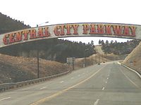
Central City Parkway
Encyclopedia
The Central City Parkway is a four-lane highway in Colorado
, running from I-70 near Idaho Springs
to the historic mining town and gambling area of Central City
. Opened on November 19, 2004, the Parkway provides direct access to Central City
. The length of the Parkway is 8.4 miles (13 km), and it can be traveled in about twelve minutes. As part of the opening ceremonies in 2004, 1996 Indianapolis 500 winner, Buddy Lazier, made the trip from I-70 to Central City's historic downtown in three minutes.
, which is there concurrent with U.S. Route 6
and U.S. Route 40
. At the interchange, CR 314 serves as a frontage road. Heading northward, the parkway abruptly turns left. After passing through several hills in a forested area, the road curves around again and heads northeastward, winding through hills. At the Clear Creek
/Gilpin
county line, the road turns northward, then northeastward, passing into a more heavily forested area. Through the drive, the road continues to wind between northward and westward before entering the vicinity of Central City
, where it meets its terminus at Nevada Street. At the terminus, Nevada Street curves abruptly eastward, making both northward and eastward continuations at the intersection named as Nevada Street.
and Cripple Creek. Black Hawk lies a mile closer to the Denver area along State Highway 119
, the primary route to the area from Interstate 70, spurring planning for a direct route to Central City from I-70 that began in 1993.
 In the mid-1990s, the city of Black Hawk backed a proposal for a state-funded widening of Highway 119 including a tunnel that would link to I-70 one mile (1.6 km) closer to Denver than Central City's off-ramp. Central City continued with its plans for a south access highway despite the city of Black Hawk acquiring land in the path of the proposed road. The issue was brought before a Denver grand jury that decided Black Hawk officials had misspent taxpayer money. Central City then sued Black Hawk for $100 million; Black Hawk countersued. Prior to dropping the lawsuit, the road was funded by bonds with a 30-year tax levy on business property to pay for the road.
Six months before the parkway opened, a report issued by gambling industry consultant Gaming & Resort Development predicted the road would be more beneficial to Black Hawk than to Central City.
Central City's gaming revenues have substantially increased since the road's opening in November 2004 but have not reached industry and city projections. Since the Parkway's opening, three casinos in Central City have opened and two, under the same ownership, have closed (The Teller House in July 2005 and Scarlet's Casino in September 2006).
Century Casinos opened in July, 2006.
Between I-70 and Central City, there is only one public exit road from the Central City Parkway: the Hidee Mine Road at mile 6.3. This road leads to the Hidee Gold Mine, which offers mine tours and gold panning, and is open to the public.
Colorado
Colorado is a U.S. state that encompasses much of the Rocky Mountains as well as the northeastern portion of the Colorado Plateau and the western edge of the Great Plains...
, running from I-70 near Idaho Springs
Idaho Springs, Colorado
The City of Idaho Springs is a municipality in the U.S. state of Colorado that is the most populous settlement in Clear Creek County, Colorado. Idaho Springs is located in Clear Creek Canyon, in the mountains upstream from Golden, some thirty miles west of Denver...
to the historic mining town and gambling area of Central City
Central City, Colorado
Central City is a home rule municipality in Clear Creek and Gilpin counties in the U.S. state of Colorado, and the county seat of Gilpin County. The city population was 515 in the 2000 United States Census...
. Opened on November 19, 2004, the Parkway provides direct access to Central City
Central City, Colorado
Central City is a home rule municipality in Clear Creek and Gilpin counties in the U.S. state of Colorado, and the county seat of Gilpin County. The city population was 515 in the 2000 United States Census...
. The length of the Parkway is 8.4 miles (13 km), and it can be traveled in about twelve minutes. As part of the opening ceremonies in 2004, 1996 Indianapolis 500 winner, Buddy Lazier, made the trip from I-70 to Central City's historic downtown in three minutes.
Route description
The parkway begins at I-70Interstate 70 in Colorado
Interstate 70 is a transcontinental Interstate Highway in the United States, stretching from Cove Fort, Utah to Baltimore, Maryland. In Colorado, the highway traverses an east–west route across the center of the state. In western Colorado, the highway connects the metropolitan areas of Grand...
, which is there concurrent with U.S. Route 6
U.S. Route 6
U.S. Route 6 , also called the Grand Army of the Republic Highway, a name that honors an American Civil War veterans association, is a main route of the U.S. Highway system, running east-northeast from Bishop, California to Provincetown, Massachusetts. Until 1964, it continued south from Bishop to...
and U.S. Route 40
U.S. Route 40
U.S. Route 40 is an east–west United States highway. As with most routes whose numbers end in a zero, U.S. 40 once traversed the entire United States. It is one of the original 1920s U.S. Highways, and its first termini were San Francisco, California, and Atlantic City, New Jersey...
. At the interchange, CR 314 serves as a frontage road. Heading northward, the parkway abruptly turns left. After passing through several hills in a forested area, the road curves around again and heads northeastward, winding through hills. At the Clear Creek
Clear Creek County, Colorado
Clear Creek County is one of the 64 counties of the state of Colorado of the United States. The county population was 9,322 at U.S. Census 2000. The county seat is Georgetown...
/Gilpin
Gilpin County, Colorado
Gilpin County is the second least extensive of the 64 counties of the State of Colorado of the United States. Gilpin County was named after Colonel William Gilpin, the first Governor of the Territory of Colorado. The county population was 4,757 at U.S. Census 2000. The county seat is Central City...
county line, the road turns northward, then northeastward, passing into a more heavily forested area. Through the drive, the road continues to wind between northward and westward before entering the vicinity of Central City
Central City, Colorado
Central City is a home rule municipality in Clear Creek and Gilpin counties in the U.S. state of Colorado, and the county seat of Gilpin County. The city population was 515 in the 2000 United States Census...
, where it meets its terminus at Nevada Street. At the terminus, Nevada Street curves abruptly eastward, making both northward and eastward continuations at the intersection named as Nevada Street.
History
Limited-stakes gambling was approved by Colorado voters in 1990 in the towns of Central City, Black HawkBlack Hawk, Colorado
The historic City of Black Hawk is a Home Rule Municipality located in Gilpin County, Colorado, United States. The city population was 118 at U.S. Census 2000, making Black Hawk the least populous city in Colorado...
and Cripple Creek. Black Hawk lies a mile closer to the Denver area along State Highway 119
Colorado State Highway 119
State Highway 119 is a long state highway in north central Colorado. It extends in a southwest to northeast direction, from a junction with US Route 6 in Clear Creek Canyon between Golden and Idaho Springs to a junction with I-25 east of Longmont....
, the primary route to the area from Interstate 70, spurring planning for a direct route to Central City from I-70 that began in 1993.
Six months before the parkway opened, a report issued by gambling industry consultant Gaming & Resort Development predicted the road would be more beneficial to Black Hawk than to Central City.
Central City's gaming revenues have substantially increased since the road's opening in November 2004 but have not reached industry and city projections. Since the Parkway's opening, three casinos in Central City have opened and two, under the same ownership, have closed (The Teller House in July 2005 and Scarlet's Casino in September 2006).
Century Casinos opened in July, 2006.
Between I-70 and Central City, there is only one public exit road from the Central City Parkway: the Hidee Mine Road at mile 6.3. This road leads to the Hidee Gold Mine, which offers mine tours and gold panning, and is open to the public.
Major intersections
| County | Location | Mile | Destination | Notes |
|---|---|---|---|---|
| Clear Creek Clear Creek County, Colorado Clear Creek County is one of the 64 counties of the state of Colorado of the United States. The county population was 9,322 at U.S. Census 2000. The county seat is Georgetown... |
0.0 | Interchange | ||
| Gilpin Gilpin County, Colorado Gilpin County is the second least extensive of the 64 counties of the State of Colorado of the United States. Gilpin County was named after Colonel William Gilpin, the first Governor of the Territory of Colorado. The county population was 4,757 at U.S. Census 2000. The county seat is Central City... |
Central City Central City, Colorado Central City is a home rule municipality in Clear Creek and Gilpin counties in the U.S. state of Colorado, and the county seat of Gilpin County. The city population was 515 in the 2000 United States Census... |
8.4 | Nevada St. |
External links
- Central City Parkway official website
- Colorado Highways: Major Non-State Roadways at The Highways of Colorado