
Castor bay
Encyclopedia
Bay
A bay is an area of water mostly surrounded by land. Bays generally have calmer waters than the surrounding sea, due to the surrounding land blocking some waves and often reducing winds. Bays also exist as an inlet in a lake or pond. A large bay may be called a gulf, a sea, a sound, or a bight...
and suburb
Suburb
The word suburb mostly refers to a residential area, either existing as part of a city or as a separate residential community within commuting distance of a city . Some suburbs have a degree of administrative autonomy, and most have lower population density than inner city neighborhoods...
of Auckland
Auckland
The Auckland metropolitan area , in the North Island of New Zealand, is the largest and most populous urban area in the country with residents, percent of the country's population. Auckland also has the largest Polynesian population of any city in the world...
in the North Island
North Island
The North Island is one of the two main islands of New Zealand, separated from the much less populous South Island by Cook Strait. The island is in area, making it the world's 14th-largest island...
of New Zealand
New Zealand
New Zealand is an island country in the south-western Pacific Ocean comprising two main landmasses and numerous smaller islands. The country is situated some east of Australia across the Tasman Sea, and roughly south of the Pacific island nations of New Caledonia, Fiji, and Tonga...
. Located between Milford
Milford, New Zealand
Milford is a suburb of Auckland, New Zealand's largest city. Located on Auckland's North Shore and part of North Shore City, Milford is located on the northern side of Lake Pupuke. It also has a popular swimming beach, which runs some two kilometers from Black Rock in the south to Castor Bay in the...
and Campbells Bay
Campbells Bay
Campbells Bay is a suburb in Auckland City in New Zealand. The suburb is under the local governance of the Auckland Council. The population was 2,316 in the 2006 Census, an increase of 111 from 2001...
it forms part of Auckland
Auckland
The Auckland metropolitan area , in the North Island of New Zealand, is the largest and most populous urban area in the country with residents, percent of the country's population. Auckland also has the largest Polynesian population of any city in the world...
's East Coast Bays
East Coast Bays
East Coast Bays is the collective name for a series of small suburbs of North Shore City, in the Auckland metropolitan area of New Zealand, which line the northeast coast of the city along the shore of the Hauraki Gulf and Rangitoto Channel...
. To the east lies the islands of Rangitoto
Rangitoto Island
Rangitoto Island is a volcanic island in the Hauraki Gulf near Auckland, New Zealand. The 5.5 km wide island is an iconic and widely visible landmark of Auckland with its distinctive symmetrical shield volcano cone rising 260 metres high over the Hauraki Gulf...
and Motutapu
Motutapu Island
Motutapu Island is a island in the Hauraki Gulf to the northeast of the city of Auckland, New Zealand. The island is part of the Hauraki Gulf Maritime Park....
which are easily visible from land. The suburb is in the North Shore ward, one of the thirteen administrative divisions of Auckland City.
The population was 2,877 in the 2006 Census
New Zealand Census of Population and Dwellings
The New Zealand government department Statistics New Zealand conducts a census of population and dwellings every five years. The census scheduled for 2011 was cancelled due to circumstances surrounding the February 2011 Christchurch earthquake, however, and legislation introduced to hold the next...
, an increase of 93 from 2001.
The bay itself is quite small and is well sheltered by an artificial Breakwater (structure)
Breakwater (structure)
Breakwaters are structures constructed on coasts as part of coastal defence or to protect an anchorage from the effects of weather and longshore drift.-Purposes of breakwaters:...
that extends from the northern edge of the bay, running towards the south. A small bark and grass area with several large Pōhutukawa
Pohutukawa
The Pōhutukawa is a coastal evergreen tree in the myrtle family, Myrtaceae, that produces a brilliant display of red flowers made up of a mass of stamens. The Pōhutukawa is one of twelve Metrosideros species endemic to New Zealand...
trees offering shelter compliments the beachfront and an extended coastline stretches out to the north towards Campbells Bay.
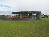
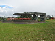
Nearby John F. Kennedy
John F. Kennedy
John Fitzgerald "Jack" Kennedy , often referred to by his initials JFK, was the 35th President of the United States, serving from 1961 until his assassination in 1963....
Park contains old World War II
World War II
World War II, or the Second World War , was a global conflict lasting from 1939 to 1945, involving most of the world's nations—including all of the great powers—eventually forming two opposing military alliances: the Allies and the Axis...
bunker
Bunker
A military bunker is a hardened shelter, often buried partly or fully underground, designed to protect the inhabitants from falling bombs or other attacks...
s that were used to survey the Hauraki Gulf
Hauraki Gulf
The Hauraki Gulf is a coastal feature of the North Island of New Zealand. It has a total area of 4000 km², and lies between the Auckland Region, the Hauraki Plains, the Coromandel Peninsula and Great Barrier Island...
and is accessible from Castor Bay by road (Beach Road) or by walkway (from the extended coastline to the north).
The northern headland of Castor Bay is the site of an old Maori Pa, Rahopara, that is believed to have been last inhabited and then abandoned in the 18th century, prior to European colonisation. Very little is known about the people who lived there but the tribe's ancient earth excavations are still visible.
Sam Hunt, one of New Zealand's most well known poets was born in Castor Bay.
The local primary school is Campbells Bay Primary School
Campbells Bay Primary School
Campbells Bay Primary School is located between Campbells Bay and Castor Bay on Auckland's North Shore. It is attended by children from the ages of 5 to 11. When they leave at the end of year 6, pupils usually move on to Takapuna Normal Intermediate School or Murrays Bay Intermediate...
located on Aberdeen Road, nearby the Pupuke Golf Course. It has a decile rating
Socio-Economic Decile
Decile, Socio-Economic Decile or Socio-Economic Decile Band is a widely used measure in education in New Zealand used to target funding and support to more needy schools....
of 10 and a roll of 662. The school opened in 1925.