
Cascade Locks, Oregon
Encyclopedia
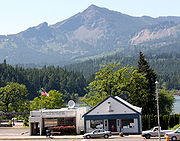
Cascade Locks is a city in Hood River County
, Oregon
, United States
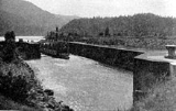
. The city took its name from a set of locks
built to improve navigation past the Cascades Rapids
of the Columbia River
. The U.S. federal government approved the plan for the locks in 1875, construction began in 1878, and the locks were completed on November 5, 1896. The locks were subsequently submerged in 1938, replaced by Bonneville Lock and Dam
, although the city lost no land from the expansion of Lake Bonneville behind the dam located some four miles (6 km) downstream of the city.
 Cascade Locks is located just upstream from the Bridge of the Gods
, a toll bridge that spans the Columbia River. It is the only bridge across the Columbia between Portland
and Hood River
. Cascade Locks is also a few miles upstream of Eagle Creek Gorge, a popular scenic area that doubles as an alternate route for the Pacific Crest Trail. Cascade Locks is used frequently by hikers along the Pacific Crest Trail
(PCT) to cross the Columbia River. Cascade Locks is the lowest point along the trail, which runs from the Mexican border in California
to the Canadian border in Washington.
Since 1999, the Confederated Tribes of Warm Springs
have been pursuing an off-reservation casino to be sited in Cascade Locks.
As of the 2000 Census, the city's population was 1,115. The 2007 estimate is 1,075 residents.
, the city has a total area of 3 square miles (7.8 km²), of which 2.2 square miles (5.7 km²) is land and 0.8 square miles (2.1 km²) (27.85%) is water.
of 2000, there were 1,115 people, 427 households, and 313 families residing in the city. The population density
was 517.8 people per square mile (200.2/km²). There were 476 housing units at an average density of 221.0 per square mile (85.5/km²). The racial makeup of the city was 89.15% White, 0.09% African American, 4.22% Native American, 0.72% Asian, 2.60% from other races
, and 3.23% from two or more races. Hispanic or Latino of any race were 7.17% of the population.
There were 427 households out of which 37.2% had children under the age of 18 living with them, 57.4% were married couples
living together, 11.7% had a female householder with no husband present, and 26.5% were non-families. 21.5% of all households were made up of individuals and 8.2% had someone living alone who was 65 years of age or older. The average household size was 2.61 and the average family size was 2.98.
In the city the population was spread out with 28.7% under the age of 18, 6.7% from 18 to 24, 31.5% from 25 to 44, 21.4% from 45 to 64, and 11.7% who were 65 years of age or older. The median age was 36 years. For every 100 females there were 98.8 males. For every 100 females age 18 and over, there were 97.3 males.
The median income for a household in the city was $35,284, and the median income for a family was $37,422. Males had a median income of $35,469 versus $25,234 for females. The per capita income
for the city was $15,359. About 17.0% of families and 19.0% of the population were below the poverty line, including 22.1% of those under age 18 and 9.4% of those age 65 or over.
!colspan=3|Historic Columbia River Highway
|-
|align=center|Sheridan State Park
MP 44
|align=center|Cascade Locks
MP 45-46
|align=center|Herman Creek Bridge
MP 47.7
Hood River County, Oregon
-Demographics:As of the census of 2000, there were 20,411 people, 7,248 households, and 5,175 families residing in the county. The population density was 39 people per square mile . There were 7,818 housing units at an average density of 15 per square mile...
, Oregon
Oregon
Oregon is a state in the Pacific Northwest region of the United States. It is located on the Pacific coast, with Washington to the north, California to the south, Nevada on the southeast and Idaho to the east. The Columbia and Snake rivers delineate much of Oregon's northern and eastern...
, United States
United States
The United States of America is a federal constitutional republic comprising fifty states and a federal district...
. The city took its name from a set of locks
Cascade Locks and Canal
The Cascade Locks and Canal was a navigation project on the Columbia River between the U.S. states of Oregon and Washington, completed in 1896. It allowed the steamboats of the Columbia River to bypass the Cascades Rapids, and thereby opened a passage from the lower parts of the river as far as The...
built to improve navigation past the Cascades Rapids
Cascades Rapids
The Cascades Rapids were an area of rapids along North America's Columbia River, between the U.S. states of Washington and Oregon. Through a stretch approximately wide, the river dropped about in .-Boat portage:Boat travelers were forced to either portage boats and supplies or pull boats up with...
of the Columbia River
Columbia River
The Columbia River is the largest river in the Pacific Northwest region of North America. The river rises in the Rocky Mountains of British Columbia, Canada, flows northwest and then south into the U.S. state of Washington, then turns west to form most of the border between Washington and the state...
. The U.S. federal government approved the plan for the locks in 1875, construction began in 1878, and the locks were completed on November 5, 1896. The locks were subsequently submerged in 1938, replaced by Bonneville Lock and Dam
Bonneville Dam
Bonneville Lock and Dam consists of several run-of-the-river dam structures that together complete a span of the Columbia River between the U.S. states of Oregon and Washington at River Mile 146.1. The dam is located east of Portland, Oregon, in the Columbia River Gorge. The primary functions of...
, although the city lost no land from the expansion of Lake Bonneville behind the dam located some four miles (6 km) downstream of the city.
Bridge of the Gods (modern structure)
The Bridge of the Gods is a steel truss cantilever bridge that spans the Columbia River between Cascade Locks, Oregon and Washington state near North Bonneville. It is approximately 40 miles east of Portland, Oregon and 4 miles upriver from the Bonneville Dam...
, a toll bridge that spans the Columbia River. It is the only bridge across the Columbia between Portland
Portland, Oregon
Portland is a city located in the Pacific Northwest, near the confluence of the Willamette and Columbia rivers in the U.S. state of Oregon. As of the 2010 Census, it had a population of 583,776, making it the 29th most populous city in the United States...
and Hood River
Hood River, Oregon
The city of Hood River is the seat of Hood River County, Oregon, United States. It is a port on the Columbia River, and is named for the nearby Hood River. As of the 2000 census, the city population was 5,831...
. Cascade Locks is also a few miles upstream of Eagle Creek Gorge, a popular scenic area that doubles as an alternate route for the Pacific Crest Trail. Cascade Locks is used frequently by hikers along the Pacific Crest Trail
Pacific Crest Trail
The Pacific Crest Trail is a long-distance mountain hiking and equestrian trail on the Western Seaboard of the United States. The southern terminus is at the California border with Mexico...
(PCT) to cross the Columbia River. Cascade Locks is the lowest point along the trail, which runs from the Mexican border in California
California
California is a state located on the West Coast of the United States. It is by far the most populous U.S. state, and the third-largest by land area...
to the Canadian border in Washington.
Since 1999, the Confederated Tribes of Warm Springs
Confederated Tribes of Warm Springs
The Confederated Tribes of Warm Springs is a federally recognized confederation of Native American Tribes who currently live on and govern the Warm Springs Indian Reservation in the U.S...
have been pursuing an off-reservation casino to be sited in Cascade Locks.
As of the 2000 Census, the city's population was 1,115. The 2007 estimate is 1,075 residents.
Geography
According to the United States Census BureauUnited States Census Bureau
The United States Census Bureau is the government agency that is responsible for the United States Census. It also gathers other national demographic and economic data...
, the city has a total area of 3 square miles (7.8 km²), of which 2.2 square miles (5.7 km²) is land and 0.8 square miles (2.1 km²) (27.85%) is water.
Demographics
As of the censusCensus
A census is the procedure of systematically acquiring and recording information about the members of a given population. It is a regularly occurring and official count of a particular population. The term is used mostly in connection with national population and housing censuses; other common...
of 2000, there were 1,115 people, 427 households, and 313 families residing in the city. The population density
Population density
Population density is a measurement of population per unit area or unit volume. It is frequently applied to living organisms, and particularly to humans...
was 517.8 people per square mile (200.2/km²). There were 476 housing units at an average density of 221.0 per square mile (85.5/km²). The racial makeup of the city was 89.15% White, 0.09% African American, 4.22% Native American, 0.72% Asian, 2.60% from other races
Race (United States Census)
Race and ethnicity in the United States Census, as defined by the Federal Office of Management and Budget and the United States Census Bureau, are self-identification data items in which residents choose the race or races with which they most closely identify, and indicate whether or not they are...
, and 3.23% from two or more races. Hispanic or Latino of any race were 7.17% of the population.
There were 427 households out of which 37.2% had children under the age of 18 living with them, 57.4% were married couples
Marriage
Marriage is a social union or legal contract between people that creates kinship. It is an institution in which interpersonal relationships, usually intimate and sexual, are acknowledged in a variety of ways, depending on the culture or subculture in which it is found...
living together, 11.7% had a female householder with no husband present, and 26.5% were non-families. 21.5% of all households were made up of individuals and 8.2% had someone living alone who was 65 years of age or older. The average household size was 2.61 and the average family size was 2.98.
In the city the population was spread out with 28.7% under the age of 18, 6.7% from 18 to 24, 31.5% from 25 to 44, 21.4% from 45 to 64, and 11.7% who were 65 years of age or older. The median age was 36 years. For every 100 females there were 98.8 males. For every 100 females age 18 and over, there were 97.3 males.
The median income for a household in the city was $35,284, and the median income for a family was $37,422. Males had a median income of $35,469 versus $25,234 for females. The per capita income
Per capita income
Per capita income or income per person is a measure of mean income within an economic aggregate, such as a country or city. It is calculated by taking a measure of all sources of income in the aggregate and dividing it by the total population...
for the city was $15,359. About 17.0% of families and 19.0% of the population were below the poverty line, including 22.1% of those under age 18 and 9.4% of those age 65 or over.
External links
- City of Cascade Locks (official)
- Cascade Locks Tourism and Port (official)
- Cascade Locks Facebook page
- Port of Cascade Locks (official)
!colspan=3|Historic Columbia River Highway
|-
|align=center|Sheridan State Park
MP 44
|align=center|Cascade Locks
MP 45-46
|align=center|Herman Creek Bridge
MP 47.7