
Camel's Hump
Encyclopedia
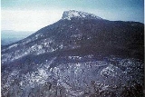
Camel's Hump is Vermont
's third-highest mountain
and highest undeveloped peak; moreover, because of its distinctive profile, it is perhaps the state's most recognized mountain. Part of the Green Mountain
range, it is one of the oldest mountains on Earth. With its neighbor to the north, Mount Mansfield
, it borders the notch that the antecedent Winooski River
has carved through this area over eons. The hiking trails on Camel's Hump were among the first cut in the Long Trail
system, and Camel's Hump remains a popular summit for through- and day-hiking. The mountain is part of Camel's Hump State Park.
s first saw the mountain, probably on Samuel de Champlain
's 1609 trip down Lake Champlain
to the west, the mountain has had a number of names related to its distinctive shape. De Champlain named the mountain "Le Lion Couchant", a heraldic image which roughly translates as "The Resting Lion". Ira Allen
later referred to the mountain as "Camel's Rump" on a map from 1798. It was not until 1830 that the name "Camel's Hump" came into usage.
The Geographic Names Information System
(GNIS) lists twelve variant names including Tah-wak-be-dee-ee-so wadso and Catamountain. While place names are determined by local usage the U.S. Board on Geographic Names (BGN) serves as a central authority in the United States concerning place names. Since its inception in 1890 the BGN has discouraged the use of the genitive apostrophe. This sometimes results in confusion. Local usage is often at odds with this policy and so the name of this mountain is alternatively spelled with and without an apostrophe.
action, the mountain's conical silhouette is distinctive, if misleading. It has two "humps", with the southernmost being the higher, and a steep drop to the south as a result of a quarrying action of the ice passing over it. While it looks somewhat volcanic from the east and west, the movement of glacial ice created its current form and the National Park Service
names the peak as "an exceptional illustration of the complex anticlinal deformation which formed the Green Mountains".
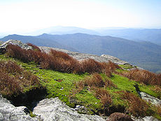 The summit of Camel's Hump is home to 10 acres (4 ha) of alpine tundra
vegetation. Plants found in this region include: bigelow sedge
, alpine bilberry
, mountain sandwort
, crowberry
, mountain cranberry
, Labrador tea
.
A direct result of glacial formation, these alpine species were once widespread but as the lower elevations warmed, only the very peak of Camel's Hump remained hospitable to the fragile plants. Camel's Hump also supports a significant population of red spruce
trees which have been under decline.
The Forest Decline Project at the University of Vermont
published a study in 1991 citing acid rain as a culprit of the reduced seed production and germination.
In 1905, publisher and philanthropist Joseph Battell
donated 1200 acres (4.9 km²) of virgin forest, including the summit of Camel's Hump, to the State of Vermont.
The bequest was intended to form a state park to be kept in a "primitive state" and in 1911 the state forester was given charge of the area who managed the land in accordance with Battell's wishes. Since then, Vermont has adopted new legislation to preserve its natural areas and in 1969 created a Forest Reserve enclosing the mountain. Camel's Hump State Park has grown since the original bequest and in 1991 totalled approximately 20000 acres (81 km²).
In October 1944, during World War II
, a B-24J bomber on a training mission crashed into the side of the mountain near the summit. While most of the plane was salvaged and removed, portions of the wreckage (principally a wing section) still remain. The Alpine Trail passes by the site.
Though protected, the Camel's Hump area is a favorite recreational venue for hikers. Trail work began on Camel's Hump at the formation of the Green Mountain Club
(GMC) and by 1912, a trail had been constructed between the mountain and Sterling Pond.
This initial trail would later become a high point in the "footpath in the wilderness" known as the Long Trail
. In the 1950s, the GMC constructed shelters along the trail and at the summit. The GMC now trains and pays a caretaker to reside at the summit and educate hikers to respect the fragile alpine ecosystem that exists on the mountain.
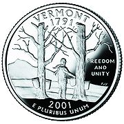
In 1999, an image of Camel's Hump was chosen as a prominent feature for the Vermont state quarter. While many other options were considered, including covered bridges and the snowflake photographs of Wilson Bentley
, the seven-person panel ultimately decided on Camel's Hump stating that it was "perfect for the quarter." The panels findings explained the choice: "It's wild and natural, like the Vermont countryside. It's unique and asymmetrical, like the independent and quirky reputation Vermonters have."
Many notable Vermont institutions have adopted its memorable name, including the children's radio show "Camel's Hump Radio" hosted by Bill Harley
on Vermont Public Radio
.
The profile of Camel's Hump appears in the Vermont coat of arms on the Vermont flag
.
 "With the only undeveloped alpine area in the Green Mountain State and a skyline that sets it apart from everything else, Camel's Hump may be Vermont's finest peak," says Michael Lanza in his guidebook for New England hiking enthusiasts. The views from the summit are panoramic, and on a clear day one can see Mount Marcy
in New York, Mount Washington
in New Hampshire and Vermont's Mount Mansfield
, the highest peaks of these three states.
Burrows ascends the west face from the end of Camel's Hump Road taken east from Huntington
and is roughly 2.4 miles (3.9 km) from trailhead to summit. The Burrows Trail is also used in the winter as a snowshoe and ski route.
An alternative trailhead approximately 0.5 mile (0.80467 km) downhill from the Burrows trailhead on Camel's Hump Road, the Forest City Trail heads farther south, passes some very picturesque streams and waterfalls, and meets the Long Trail
at Montclair Glen Lodge. From this location, the Long Trail climbs the south face, which is steep and mildly technical towards the summit. There is a short connector trail, connecting the bottom of Burrows Trail to the waterfall bridges at Forest City, for those choosing to use the Burrows Trail upon descent.
The Monroe Trail ascends the east face, which is an easy to moderate trail similar to the Burrows Trail, but slightly longer.
The Long Trail continues north from the summit, and there are numerous side trails around the summit itself that are good for exploration in the summer.
There is a clearing approximately 200 yards (182.9 m) north of the summit, where the Burrows and Monroe Trails intersect the Long Trail. The clearing is the last protected environment one faces when climbing the mountain from the north, and once above treeline winds and temperatures can be severe at times.
Vermont
Vermont is a state in the New England region of the northeastern United States of America. The state ranks 43rd in land area, , and 45th in total area. Its population according to the 2010 census, 630,337, is the second smallest in the country, larger only than Wyoming. It is the only New England...
's third-highest mountain
Mountain
Image:Himalaya_annotated.jpg|thumb|right|The Himalayan mountain range with Mount Everestrect 58 14 160 49 Chomo Lonzorect 200 28 335 52 Makalurect 378 24 566 45 Mount Everestrect 188 581 920 656 Tibetan Plateaurect 250 406 340 427 Rong River...
and highest undeveloped peak; moreover, because of its distinctive profile, it is perhaps the state's most recognized mountain. Part of the Green Mountain
Green Mountains
The Green Mountains are a mountain range in the U.S. state of Vermont. The range extends approximately .-Peaks:The most notable mountains in the range include:*Mount Mansfield, , the highest point in Vermont*Killington Peak, *Mount Ellen,...
range, it is one of the oldest mountains on Earth. With its neighbor to the north, Mount Mansfield
Mount Mansfield
Mount Mansfield is the highest mountain in Vermont with a summit that peaks at above sea level. The summit is in Underhill; the ridgeline, including some secondary peaks, extends into the town of Stowe, and the mountain's flanks also reach into the town of Cambridge.When viewed from the east or...
, it borders the notch that the antecedent Winooski River
Winooski River
The Winooski River is a tributary of Lake Champlain, approximately long, in northern Vermont in the United States. Although not Vermont's longest river, it is one of the state's most significant, forming a major valley way from Lake Champlain through the Green Mountains towards the Connecticut...
has carved through this area over eons. The hiking trails on Camel's Hump were among the first cut in the Long Trail
Long Trail
The Long Trail is a hiking trail located in Vermont, running the length of the state. It is the oldest long-distance trail in the United States, constructed between 1910 and 1930 by the Green Mountain Club...
system, and Camel's Hump remains a popular summit for through- and day-hiking. The mountain is part of Camel's Hump State Park.
Name
Since EuropeanEuropean ethnic groups
The ethnic groups in Europe are the various ethnic groups that reside in the nations of Europe. European ethnology is the field of anthropology focusing on Europe....
s first saw the mountain, probably on Samuel de Champlain
Samuel de Champlain
Samuel de Champlain , "The Father of New France", was a French navigator, cartographer, draughtsman, soldier, explorer, geographer, ethnologist, diplomat, and chronicler. He founded New France and Quebec City on July 3, 1608....
's 1609 trip down Lake Champlain
Lake Champlain
Lake Champlain is a natural, freshwater lake in North America, located mainly within the borders of the United States but partially situated across the Canada—United States border in the Canadian province of Quebec.The New York portion of the Champlain Valley includes the eastern portions of...
to the west, the mountain has had a number of names related to its distinctive shape. De Champlain named the mountain "Le Lion Couchant", a heraldic image which roughly translates as "The Resting Lion". Ira Allen
Ira Allen
Ira Allen was one of the founders of Vermont, and leaders of the Green Mountain Boys; and was the brother of Ethan Allen.-Biography:...
later referred to the mountain as "Camel's Rump" on a map from 1798. It was not until 1830 that the name "Camel's Hump" came into usage.
The Geographic Names Information System
Geographic Names Information System
The Geographic Names Information System is a database that contains name and locative information about more than two million physical and cultural features located throughout the United States of America and its territories. It is a type of gazetteer...
(GNIS) lists twelve variant names including Tah-wak-be-dee-ee-so wadso and Catamountain. While place names are determined by local usage the U.S. Board on Geographic Names (BGN) serves as a central authority in the United States concerning place names. Since its inception in 1890 the BGN has discouraged the use of the genitive apostrophe. This sometimes results in confusion. Local usage is often at odds with this policy and so the name of this mountain is alternatively spelled with and without an apostrophe.
Geology
Camel's Hump is more notable for its shape than its height. Isolated from neighboring peaks by the Winooski Valley and glacialGlacier
A glacier is a large persistent body of ice that forms where the accumulation of snow exceeds its ablation over many years, often centuries. At least 0.1 km² in area and 50 m thick, but often much larger, a glacier slowly deforms and flows due to stresses induced by its weight...
action, the mountain's conical silhouette is distinctive, if misleading. It has two "humps", with the southernmost being the higher, and a steep drop to the south as a result of a quarrying action of the ice passing over it. While it looks somewhat volcanic from the east and west, the movement of glacial ice created its current form and the National Park Service
National Park Service
The National Park Service is the U.S. federal agency that manages all national parks, many national monuments, and other conservation and historical properties with various title designations...
names the peak as "an exceptional illustration of the complex anticlinal deformation which formed the Green Mountains".
Botany
Alpine tundra
Alpine tundra is a natural region that does not contain trees because it is at high altitude. Alpine tundra is distinguished from arctic tundra, because alpine soils are generally better drained than arctic soils...
vegetation. Plants found in this region include: bigelow sedge
Carex
Carex is a genus of plants in the family Cyperaceae, commonly known as sedges. Other members of the Cyperaceae family are also called sedges, however those of genus Carex may be called "true" sedges, and it is the most species-rich genus in the family. The study of Carex is known as...
, alpine bilberry
Bilberry
Bilberry is any of several species of low-growing shrubs in the genus Vaccinium , bearing edible berries. The species most often referred to is Vaccinium myrtillus L., but there are several other closely related species....
, mountain sandwort
Arenaria (plant)
Arenaria is a genus of flowering plants, within the family Caryophyllaceae.Species of this genus are among those plants commonly known as "sandworts". Several species formerly classified within Arenaria are now classed in the genera Spergularia, Eremogone and Minuartia.Species include:*Arenaria...
, crowberry
Crowberry
Crowberry is a small genus of dwarf evergreen shrubs that bear edible fruit. They are commonly found in the northern hemisphere, from temperate to subarctic climates, and also in the Southern Andes of South America and on the South Atlantic islands of South Georgia, the Falklands and Tristan da...
, mountain cranberry
Vaccinium vitis-idaea
Vaccinium vitis-idaea is a short evergreen shrub in the heath family that bears edible sour fruit, native to boreal forest and Arctic tundra throughout the Northern Hemisphere from Eurasia to North America. In the past it was seldom cultivated, but fruit was commonly collected in the wild. ...
, Labrador tea
Labrador tea
Labrador tea is a name commonly applied to three closely related species:* Rhododendron tomentosum ,...
.
A direct result of glacial formation, these alpine species were once widespread but as the lower elevations warmed, only the very peak of Camel's Hump remained hospitable to the fragile plants. Camel's Hump also supports a significant population of red spruce
Red Spruce
Picea rubens is a species of spruce native to eastern North America, ranging from eastern Quebec to Nova Scotia, and from New England south in the Adirondack Mountains and Appalachians to western North Carolina.-Physical description:...
trees which have been under decline.
The Forest Decline Project at the University of Vermont
University of Vermont
The University of Vermont comprises seven undergraduate schools, an honors college, a graduate college, and a college of medicine. The Honors College does not offer its own degrees; students in the Honors College concurrently enroll in one of the university's seven undergraduate colleges or...
published a study in 1991 citing acid rain as a culprit of the reduced seed production and germination.
History
The Abnaki name for the mountain was "ta wak be dee esso wadso," or "tahwahbodeay wadso" (wadso meaning mountain), which has been variously translated as "resting place", "sit-down place", and "prudently, we make a campfire in a circle near water (and rest) at this mountain."In 1905, publisher and philanthropist Joseph Battell
Joseph Battell
Joseph Battell was a publisher and philanthropist from Middlebury, Vermont. Battell is credited with preserving Vermont forest land including the land for Camel's Hump State Park. Battell edited a newspaper and authored several books, including the "American Morgan Horse Registry"...
donated 1200 acres (4.9 km²) of virgin forest, including the summit of Camel's Hump, to the State of Vermont.
The bequest was intended to form a state park to be kept in a "primitive state" and in 1911 the state forester was given charge of the area who managed the land in accordance with Battell's wishes. Since then, Vermont has adopted new legislation to preserve its natural areas and in 1969 created a Forest Reserve enclosing the mountain. Camel's Hump State Park has grown since the original bequest and in 1991 totalled approximately 20000 acres (81 km²).
In October 1944, during World War II
World War II
World War II, or the Second World War , was a global conflict lasting from 1939 to 1945, involving most of the world's nations—including all of the great powers—eventually forming two opposing military alliances: the Allies and the Axis...
, a B-24J bomber on a training mission crashed into the side of the mountain near the summit. While most of the plane was salvaged and removed, portions of the wreckage (principally a wing section) still remain. The Alpine Trail passes by the site.
Though protected, the Camel's Hump area is a favorite recreational venue for hikers. Trail work began on Camel's Hump at the formation of the Green Mountain Club
Green Mountain Club
The Green Mountain Club is a non-profit membership organization dedicated to preserving and protecting Vermont's Long Trail - America's first long-distance hiking trail which stretches from Massachusetts to the Canadian border along Vermont's high ridgeline...
(GMC) and by 1912, a trail had been constructed between the mountain and Sterling Pond.
This initial trail would later become a high point in the "footpath in the wilderness" known as the Long Trail
Long Trail
The Long Trail is a hiking trail located in Vermont, running the length of the state. It is the oldest long-distance trail in the United States, constructed between 1910 and 1930 by the Green Mountain Club...
. In the 1950s, the GMC constructed shelters along the trail and at the summit. The GMC now trains and pays a caretaker to reside at the summit and educate hikers to respect the fragile alpine ecosystem that exists on the mountain.
In 1999, an image of Camel's Hump was chosen as a prominent feature for the Vermont state quarter. While many other options were considered, including covered bridges and the snowflake photographs of Wilson Bentley
Wilson Bentley
Wilson Alwyn "Snowflake" Bentley , born in Jericho, Vermont, United States is one of the first known photographers of snowflakes. He perfected a process of catching flakes on black velvet in such a way that their images could be captured before they either melted or sublimed.-Biography:Bentley was...
, the seven-person panel ultimately decided on Camel's Hump stating that it was "perfect for the quarter." The panels findings explained the choice: "It's wild and natural, like the Vermont countryside. It's unique and asymmetrical, like the independent and quirky reputation Vermonters have."
Many notable Vermont institutions have adopted its memorable name, including the children's radio show "Camel's Hump Radio" hosted by Bill Harley
Bill Harley
Bill Harley is a children's entertainer and storyteller who has been called "the Mark Twain of contemporary children's music" by Entertainment Weekly. He uses a range of musical styles and appeals to children and adults with quirky, heart-filled lyrics...
on Vermont Public Radio
Vermont Public Radio
-WVPR:-WRVT:-VPR Classical:Since 2007, VPR has broadcast classical music on a separate network. The main station is WOXR , which is licensed to Schuyler Falls, New York and serves the Burlington/Plattsburgh area....
.
The profile of Camel's Hump appears in the Vermont coat of arms on the Vermont flag
Flag of Vermont
The flag of the state of Vermont consists of the state's coat of arms and motto. The Vermont General Assembly adopted the current flag on June 1, 1923....
.
Hiking Camel's Hump
Mount Marcy
Mount Marcy is the highest point in New York State, with an elevation of . It is a popular destination for hikers due to its stature and great views, and the peak can get very crowded in the summer months...
in New York, Mount Washington
Mount Washington (New Hampshire)
Mount Washington is the highest peak in the Northeastern United States at , famous for dangerously erratic weather. For 76 years, a weather observatory on the summit held the record for the highest wind gust directly measured at the Earth's surface, , on the afternoon of April 12, 1934...
in New Hampshire and Vermont's Mount Mansfield
Mount Mansfield
Mount Mansfield is the highest mountain in Vermont with a summit that peaks at above sea level. The summit is in Underhill; the ridgeline, including some secondary peaks, extends into the town of Stowe, and the mountain's flanks also reach into the town of Cambridge.When viewed from the east or...
, the highest peaks of these three states.
Burrows ascends the west face from the end of Camel's Hump Road taken east from Huntington
Huntington, Vermont
Huntington is a town in Chittenden County, Vermont, United States. The population was 1,861 at the 2000 census.The town was originally called New Huntington but the name was changed to Huntington in 1795...
and is roughly 2.4 miles (3.9 km) from trailhead to summit. The Burrows Trail is also used in the winter as a snowshoe and ski route.
An alternative trailhead approximately 0.5 mile (0.80467 km) downhill from the Burrows trailhead on Camel's Hump Road, the Forest City Trail heads farther south, passes some very picturesque streams and waterfalls, and meets the Long Trail
Long Trail
The Long Trail is a hiking trail located in Vermont, running the length of the state. It is the oldest long-distance trail in the United States, constructed between 1910 and 1930 by the Green Mountain Club...
at Montclair Glen Lodge. From this location, the Long Trail climbs the south face, which is steep and mildly technical towards the summit. There is a short connector trail, connecting the bottom of Burrows Trail to the waterfall bridges at Forest City, for those choosing to use the Burrows Trail upon descent.
The Monroe Trail ascends the east face, which is an easy to moderate trail similar to the Burrows Trail, but slightly longer.
The Long Trail continues north from the summit, and there are numerous side trails around the summit itself that are good for exploration in the summer.
There is a clearing approximately 200 yards (182.9 m) north of the summit, where the Burrows and Monroe Trails intersect the Long Trail. The clearing is the last protected environment one faces when climbing the mountain from the north, and once above treeline winds and temperatures can be severe at times.
External links
- Camel's Hump State Park - official site