
California's 19th State Senate district
Encyclopedia
California
's 19th State Senate
District is one of 40 Senate Districts. It is currently represented by Republican
Tony Strickland
of Moorpark
.
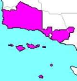
. It includes both rural and suburban areas, from the southern parts of the Central Coast to the suburbs of Los Angeles
.
The 19th includes portions of three counties, with the majority of the district's population in Ventura County
. The district includes the entire Simi Valley, including Thousand Oaks
, Camarillo
, and the city of Ventura itself.
Almost all of Santa Barbara County
is in the district, including the city of Santa Barbara
and the Santa Ynez Valley
.
The Los Angeles County
portion includes the sections of Santa Clarita
not in the 17th.
Los Angeles County
Ventura County
. The 2001 redistricting collapsed the two districts, putting the northern half of 18 into Senate District 15 and most of the Los Angeles County portion of 19 into Districts 17 and 20.
California
California is a state located on the West Coast of the United States. It is by far the most populous U.S. state, and the third-largest by land area...
's 19th State Senate
California State Senate
The California State Senate is the upper house of the California State Legislature. There are 40 state senators. The state legislature meets in the California State Capitol in Sacramento. The Lieutenant Governor is the ex officio President of the Senate and may break a tied vote...
District is one of 40 Senate Districts. It is currently represented by Republican
California Republican Party
The California Republican Party is the California affiliate of the United States Republican Party. The party chairman is Tom Del Beccaro and is based in Burbank, California, a suburb of Los Angeles. The RPC also has a headquarters in Sacramento....
Tony Strickland
Tony Strickland
Anthony A. "Tony" Strickland is a California State Senator, representing the 19th District. Strickland is a member of the Republican Party and a former Assemblyman, representing the 37th District from 1998 to 2004.-Early life:...
of Moorpark
Moorpark, California
Moorpark is a city in Southern California. It was founded in 1900 by Robert Poindexter, presumably named after the moorpark apricots that grew in the area. The city has experienced a great amount of growth since the late 1970s...
.
District profile
The 19th District includes most of Santa Barbara County and the Simi ValleySimi Valley
Simi Valley is a synclinal valley in Southern California in the United States. It is an enclosed or hidden valley surrounded by mountains and hills. It is connected to the San Fernando Valley to the east by the Santa Susana Pass & 118 freeway, and in the west the narrows of the Arroyo Simi and 118...
. It includes both rural and suburban areas, from the southern parts of the Central Coast to the suburbs of Los Angeles
Los Ángeles
Los Ángeles is the capital of the province of Biobío, in the commune of the same name, in Region VIII , in the center-south of Chile. It is located between the Laja and Biobío rivers. The population is 123,445 inhabitants...
.
The 19th includes portions of three counties, with the majority of the district's population in Ventura County
Ventura County, California
Ventura County is a county in the southern part of the U.S. state of California. It is located on California's Pacific coast. It is often referred to as the Gold Coast, and has a reputation of being one of the safest populated places and one of the most affluent places in the country...
. The district includes the entire Simi Valley, including Thousand Oaks
Thousand Oaks, California
Thousand Oaks is a city in southeastern Ventura County, California, in the United States. It was named after the many oak trees that grace the area, and the city seal is adorned with an oak....
, Camarillo
Camarillo, California
Camarillo is a city in Ventura County, California, United States. The population was 65,201 at the 2010 census, up from 57,084 at the 2000 census. The Ventura Freeway Camarillo is a city in Ventura County, California, United States. The population was 65,201 at the 2010 census, up from 57,084 at...
, and the city of Ventura itself.
Almost all of Santa Barbara County
Santa Barbara County, California
Santa Barbara County is a county located in the southern portion of the U.S. state of California, on the Pacific coast. As of 2010 the county had a population of 423,895. The county seat is Santa Barbara and the largest city is Santa Maria.-History:...
is in the district, including the city of Santa Barbara
Santa Barbara, California
Santa Barbara is the county seat of Santa Barbara County, California, United States. Situated on an east-west trending section of coastline, the longest such section on the West Coast of the United States, the city lies between the steeply-rising Santa Ynez Mountains and the Pacific Ocean...
and the Santa Ynez Valley
Santa Ynez Valley
The Santa Ynez Valley is located in Santa Barbara County, California, between the Santa Ynez Mountains to the south and the San Rafael Mountains to the north. The Santa Ynez River flows through the valley from east to west. The Santa Ynez Valley is separated from the Los Alamos Valley, to the...
.
The Los Angeles County
Los Angeles County, California
Los Angeles County is a county in the U.S. state of California. As of 2010 U.S. Census, the county had a population of 9,818,605, making it the most populous county in the United States. Los Angeles County alone is more populous than 42 individual U.S. states...
portion includes the sections of Santa Clarita
Santa Clarita, California
Santa Clarita is the fourth largest city in Los Angeles County, California, United States and the twenty-fourth largest city in the state of California. The 2010 US Census reported the city's population grew 16.7% from the year 2000 to 176,320 residents. It is located about northwest of downtown...
not in the 17th.
Communities
Santa Barbara County- BuelltonBuellton, CaliforniaBuellton is a small city in Santa Barbara County, California, United States. The city of Buellton is one of the communities that make up the Santa Ynez Valley...
- CarpinteriaCarpinteria, CaliforniaCarpinteria is a small oceanside city located in southeastern Santa Barbara County, California, east of Santa Barbara and northwest of Ventura. The population was 13,040 at the 2010 census, down from 14,194 at the 2000 census....
- LompocLompoc, CaliforniaLompoc is a city in Santa Barbara County, California, United States. The city was incorporated in 1888. The population was 42,434 at the 2010 census, up from 41,103 at the 2000 census....
- Santa BarbaraSanta Barbara, CaliforniaSanta Barbara is the county seat of Santa Barbara County, California, United States. Situated on an east-west trending section of coastline, the longest such section on the West Coast of the United States, the city lies between the steeply-rising Santa Ynez Mountains and the Pacific Ocean...
- SolvangSolvang, CaliforniaSolvang is a city in Santa Barbara County, California, United States. It is one of the communities that make up the Santa Ynez Valley. The population was 5,245 at the 2010 census, down from 5,332 at the 2000 census...
- GoletaGoleta, CaliforniaGoleta is a city in southern Santa Barbara County, California, USA. It was incorporated as a city in 2002, after a long period as the largest unincorporated, populated area in the county. As of the 2000 census, the Census-designated place had a total population of 55,204, however, a significant...
- Isla VistaIsla Vista, CaliforniaIsla Vista is an unincorporated community and census-designated place in Santa Barbara County, California in the United States. As of the 2010 census, it had a population of 23,096. The majority of residents are college students at nearby University of California, Santa Barbara or at Santa...
- Los AlamosLos Alamos, CaliforniaLos Alamos is a census-designated place in Santa Barbara County, California, United States. Although located in the Los Alamos Valley, the town of Los Alamos is usually considered to be a part of the Santa Ynez Valley community...
- Mission CanyonMission Canyon, CaliforniaMission Canyon is a census-designated place and an unincorporated suburb of Santa Barbara, California, in Santa Barbara County, United States. The population was 2,381 at the 2010 census, down from 2,610 at the 2000 census....
- Mission HillsMission Hills, CaliforniaMission Hills is a census-designated place in Santa Barbara County, California, a short distance north of Lompoc on Highway 1. The population was 3,576 at the 2010 census, up from 3,142 at the 2000 census.-Geography:...
- MontecitoMontecito, CaliforniaMontecito is an unincorporated community in Santa Barbara County, California. As a census-designated place, it had a population of 8,965 in 2010. This does not include areas such as Coast Village Road, that, while usually considered part of Montecito, are actually within the city limits of Santa...
- OrcuttOrcutt, CaliforniaOrcutt is an unincorporated township located in the Santa Maria Valley of California, and a census-designated place; it is in Santa Barbara County, California, United States. Orcutt is named for William W. Orcutt, the manager of the Geological, Land and Engineering Departments of the Union Oil...
(30.4% of residents) - Santa YnezSanta Ynez, CaliforniaSanta Ynez is a census-designated place in Santa Barbara County, California, United States. The town of Santa Ynez is one of the communities that make up the Santa Ynez Valley, and features the Santa Ynez Airport for general aviation with a paved 2804 x 75 foot runway. The population was 4,418...
- SummerlandSummerland, CaliforniaSummerland is a census-designated place in Santa Barbara County, California, United States. The population was 1,448 at the 2010 census, down from 1,545 at the 2000 census.The town includes a school and a Presbyterian Church...
- Toro CanyonToro Canyon, CaliforniaToro Canyon is a census-designated place in Santa Barbara County, California, United States. The population was 1,508 at the 2010 census, down from 1,697 at the 2000 census.-Geography:Toro Canyon is located at...
- Vandenberg Air Force BaseVandenberg Air Force BaseVandenberg Air Force Base is a United States Air Force Base, located approximately northwest of Lompoc, California. It is under the jurisdiction of the 30th Space Wing, Air Force Space Command ....
- Vandenberg VillageVandenberg Village, CaliforniaVandenberg Village is a census-designated place in the unincorporated area of Santa Barbara County, California, United States. The population was 6,497 at the 2010 census, up from 5,802 at the 2000 census.-Geography:...
Los Angeles County
- Santa ClaritaSanta Clarita, CaliforniaSanta Clarita is the fourth largest city in Los Angeles County, California, United States and the twenty-fourth largest city in the state of California. The 2010 US Census reported the city's population grew 16.7% from the year 2000 to 176,320 residents. It is located about northwest of downtown...
(27% of residents)
Ventura County
- Bell CanyonBell Canyon, CaliforniaBell Canyon is a census-designated place in Ventura County, California. Bell Canyon is a residential unincorporated community located near West Hills and the western San Fernando Valley in the Simi Hills. Although only minutes from the Los Angeles city limits, Bell Canyon is a Horse Community. ...
- CamarilloCamarillo, CaliforniaCamarillo is a city in Ventura County, California, United States. The population was 65,201 at the 2010 census, up from 57,084 at the 2000 census. The Ventura Freeway Camarillo is a city in Ventura County, California, United States. The population was 65,201 at the 2010 census, up from 57,084 at...
- MoorparkMoorpark, CaliforniaMoorpark is a city in Southern California. It was founded in 1900 by Robert Poindexter, presumably named after the moorpark apricots that grew in the area. The city has experienced a great amount of growth since the late 1970s...
- OjaiOjai, CaliforniaOjai is a city in Ventura County, California, USA. It is situated in the Ojai Valley , surrounded by hills and mountains. The population was 7,461 at the 2010 census, down from 7,862 at the 2000 census.-History:Chumash Indians were the early inhabitants of the valley...
- Simi ValleySimi Valley, California-2010:The 2010 United States Census reported that Simi Valley had a population of 124,237. The population density was 2,940.8 people per square mile...
- Thousand OaksThousand Oaks, CaliforniaThousand Oaks is a city in southeastern Ventura County, California, in the United States. It was named after the many oak trees that grace the area, and the city seal is adorned with an oak....
- VenturaVentura, CaliforniaVentura is the county seat of Ventura County, California, United States, incorporated in 1866. The population was 106,433 at the 2010 census, up from 100,916 at the 2000 census. Ventura is accessible via U.S...
- Casa ConejoCasa Conejo, CaliforniaCasa Conejo is a census-designated place in Ventura County, California, United States. It was the first planned community in Newbury Park, built between 1960 and 1965. The community is bordered by Old Conejo Road and the US 101 to the North, Borchard Road to the South, Jenny Dr. to the West, and...
- El RioEl Rio, CaliforniaEl Rio is a small unincorporated census-designated town in Ventura County, California, USA, on the northeast side of the 101 Freeway and Oxnard, and south of the Santa Clara River...
- Meiners OaksMeiners Oaks, CaliforniaMeiners Oaks is a census-designated place in Ventura County, California, United States. The population was 3,571 at the 2010 census, one person more than the 3,750 counted at the 2000 census.-Geography:...
- Mira MonteMira Monte, CaliforniaMira Monte is a census-designated place in Ventura County, California, United States. According to the 2010 census, the population of Mira Monte is 6,845, down from 7,177 at the 2000 census.-Geography:...
- Oak ParkOak Park, CaliforniaOak Park is a census-designated place located in the Simi Hills, in Ventura County, California. As of the 2010 census, Oak Park had a population of 14,266, up from 14,225 at the 2000 census...
- Oak ViewOak View, CaliforniaOak View is a census-designated place in Ventura County, California, United States located in the western portion of the Ojai Valley situated between the towns of Casitas Springs and Mira Monte . At the 2010 census, the population of Oak View was 4,066, down from 4,199 at the 2000 census, making...
2008
2004
2000
2001 redistricting
In the 1990s, the 18th and the 19th both included portions of the district. The 18th included all of Santa Barbara and the northern half of Ventura. The 19th included the Simi Valley and all of Santa Clarita, in addition to a large portion of the San Fernando ValleySan Fernando Valley
The San Fernando Valley is an urbanized valley located in the Los Angeles metropolitan area of southern California, United States, defined by the dramatic mountains of the Transverse Ranges circling it...
. The 2001 redistricting collapsed the two districts, putting the northern half of 18 into Senate District 15 and most of the Los Angeles County portion of 19 into Districts 17 and 20.