
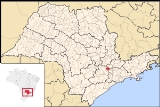
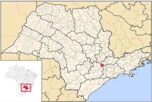
Cabreúva
Encyclopedia
| Coat of arms | |
|---|---|
 |
|
| Statistics | |
| State: | São Paulo São Paulo (state) São Paulo is a state in Brazil. It is the major industrial and economic powerhouse of the Brazilian economy. Named after Saint Paul, São Paulo has the largest population, industrial complex, and economic production in the country. It is the richest state in Brazil... |
| Meso-region: | Paulista Macro-Metropolitan Meso-Region |
| Microrregions: | Sorocaba Sorocaba (micro-region) The Microregion of Sorocaba is a microregion in the central part of São Paulo State, Brazil.- Municipalities:* Alumínio* Araçariguama* Araçoiaba da Serra* Cabreúva* Capela do Alto* Iperó* Itu* Mairinque* Porto Feliz* Salto* Salto de Pirapora... |
| Founded: | March 24 |
| Location Location (geography) The terms location and place in geography are used to identify a point or an area on the Earth's surface or elsewhere. The term 'location' generally implies a higher degree of can certainty than "place" which often has an ambiguous boundary relying more on human/social attributes of place identity... : |
23.915/23°18'27" S, 47.132/47°7'59" W |
| Area Area Area is a quantity that expresses the extent of a two-dimensional surface or shape in the plane. Area can be understood as the amount of material with a given thickness that would be necessary to fashion a model of the shape, or the amount of paint necessary to cover the surface with a single coat... : |
259.8 km² |
| Population Population A population is all the organisms that both belong to the same group or species and live in the same geographical area. The area that is used to define a sexual population is such that inter-breeding is possible between any pair within the area and more probable than cross-breeding with individuals... : |
36,106 (2004) Ranked 312nd |
| Population density Population density Population density is a measurement of population per unit area or unit volume. It is frequently applied to living organisms, and particularly to humans... : |
138.98/km² |
| Elevation Elevation The elevation of a geographic location is its height above a fixed reference point, most commonly a reference geoid, a mathematical model of the Earth's sea level as an equipotential gravitational surface .... : |
640 m |
| Postal code: | 13315-xxx |
| Area/distance code: | (00)55-15 |
| Website: | www.cabreuva.sp.gov.br |
| Population Statistics | |
| Urban: | 25,760 |
| Rural: | 7,340 |
| Other | |
| Literacy rate: | 90.05% |
Cabreúva is a municipality (município) in the state of São Paulo
São Paulo (state)
São Paulo is a state in Brazil. It is the major industrial and economic powerhouse of the Brazilian economy. Named after Saint Paul, São Paulo has the largest population, industrial complex, and economic production in the country. It is the richest state in Brazil...
in Brazil
Brazil
Brazil , officially the Federative Republic of Brazil , is the largest country in South America. It is the world's fifth largest country, both by geographical area and by population with over 192 million people...
. The population in 2003 is 36,106, the density is about 138/km² the area is 261 km² The elevation is 640 m. This place name comes from the Tupi words
Tupian languages
The Tupi or Tupian language family comprises some 70 languages spoken in South America, of which the best known are Tupi proper and Guarani.-History, members and classification:...
Kaburé-Iwa, the tree
Tree
A tree is a perennial woody plant. It is most often defined as a woody plant that has many secondary branches supported clear of the ground on a single main stem or trunk with clear apical dominance. A minimum height specification at maturity is cited by some authors, varying from 3 m to...
of the owl
Owl
Owls are a group of birds that belong to the order Strigiformes, constituting 200 bird of prey species. Most are solitary and nocturnal, with some exceptions . Owls hunt mostly small mammals, insects, and other birds, although a few species specialize in hunting fish...
and is known by the aboriginals.
History
The city was established in the beginning of 18th century by a member of the MartinsMartins
-People:* Anderson Martins, Brazilian footballer* André Renato Soares Martins, Portuguese footballer*Corentin Martins, French footballer* Dênio Martins, Brazilian footballer*Gaspar Martins, Angolan ambassador*João Carlos Martins, Brazilian pianist...
and Ramos
Ramos
This is a list of people named Ramos:* Alejandra Ramos, Chilean middle distance runner* Ariel Ramos, Cuban sport wrestler* Bartolomeo Ramos, Renaissance music theorist* Edwin Ramos, gang member* Eliana Ramos, Uruguayan model* Fidel V...
family, from the city of Itu
Itu
Itu is an old and historic municipality in the state of São Paulo in Brazil. The population in 2009 was 157,384 and the area is 641.68 km². The elevation is 583 m. This place name comes from the Tupi language, meaning big waterfall. Itu is linked with the highway numbered the SP-75 and are flowed...
, passed by the Tietê
Tietê
Tietê may refer to:* Tietê, São Paulo, a city in the state of São Paulo, Brazil;* Tietê River, a river in the same state....
river and searched a place located and founded a situated valley between the three mountain ranges (derived from the Tupi language) - they are Japi, Guaxatuba and Taguá. The area is cultivated with sugar canes which gave the origin to its local economy for some decades, which received its nickname of the city, Terra da Pinga
Pinga
In Inuit mythology, Pinga was a goddess of the hunt, fertility and medicine. She was also the psychopomp, bringing souls of the newly-dead to Adlivun, the underworld....
/Land of Pinga.
The name of this city originates from the Cabreúva tree of the medium-brown type (Myrocarpus frondosus
Myrocarpus frondosus
Myrocarpus frondosus, the Ibirá-Payé, Incienso, Quina Morada, or Qu, is a species of legume in the Fabaceae family.It is found in Argentina, Brazil, and Paraguay.It is threatened by habitat loss.-Source:...
, of the family Leguminosae-Papilionoideae).
Geography
Its landscape is dominated by two detached geographical formations: the mountain ranges of (Japi, Guaxatuba and Taguá) and the Tietê river. The altitudes vary between 640 m in the center of the city up to 1,200 m Serra do Japi. The city has 261 km², of which 96 km² are urban and 165 km² are rural.Population history
| Year | Population | Change | Density |
|---|---|---|---|
| 2001 | 33,100 | - | 127.41/km² |
| 2004 | 36,106 | - | 138.98/km² |
Demographics
According to the 2000 IBGEIBGE
The Brazilian Institute of Geography and Statistics or IBGE , is the agency responsible for statistical, geographic, cartographic, geodetic and environmental information in Brazil...
Census, the population was 33,100, of which 25,760 are urban and 7,340 are rural. Its life expectancy for the city was 71.14 years. The literacy rate was at 90.05%.
Events
- March 24: Day of the municipal anniversary
SITE VISITE CABREUVA Homepage of Cabreúva Cabreúva on citybrazil.com.br Cabreúva's Newspaper - Caleidoscópio Cabreúva's Newspaper - Mais Cabreúva Cabreúva's Telephone directory
| North: Indaiatuba Indaiatuba Indaiatuba is a municipality in the state of São Paulo in Brazil. The population in 2006 is 181,124 and has an area is 311.34 km². The elevation is 624 m. The city's name comes from the Tupi language. One of the most important city of the area.... and Itupeva Itupeva Itupeva is a municipality in the state of São Paulo in Brazil. The population in 2004 is 30,283 and the area is 201.68 km². The elevation is 675 m. This place name comes from the Tupi language. It's a rural city, you can find lot of kinds of crops growing there. It has also an urban/suburban... |
||
| West: Itu Itu Itu is an old and historic municipality in the state of São Paulo in Brazil. The population in 2009 was 157,384 and the area is 641.68 km². The elevation is 583 m. This place name comes from the Tupi language, meaning big waterfall. Itu is linked with the highway numbered the SP-75 and are flowed... |
Cabreúva | East: Jundiaí Jundiaí Jundiaí is a city and municipality in the state of São Paulo, Brazil. The population in 2009 was 349,929, and the area is 433.958 km². The elevation is 761 m. Distance is 60 km north of the city of São Paulo.- History and Geography :... |
| South: Pirapora do Bom Jesus Pirapora do Bom Jesus Pirapora do Bom Jesus is a municipality in the state of São Paulo in Brazil. The population in 2003 is 13,762, the density is 127.43/km² and the area is 108 km². Pirapora comes from the Tupi language.-See also:*Pirapora... and Araçariguama Araçariguama Araçariguama is a city in the state of São Paulo in Brazil. The population in 2003 is 13,324 and the area is 146.7 km². The origin of the name comes from the Tupi language The elevation is 695 m... |