
CARTOSAT-1
Encyclopedia
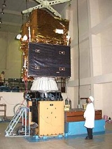
Cartosat-1 is a stereoscopic Earth observation satellite
in a sun-synchronous orbit
. The satellite was built, launched and maintained by the Indian Space Research Organisation
. Weighing around 1560 kg at launch, its applications will mainly be towards cartography
in India
. It was launched by the PSLV-C6 on 5 May 2005 from the newly built second launch pad at Sriharikota
. Images from the satellite will be available from GeoEye
for worldwide distribution.
Cartosat-1 carries two state-of-the-art panchromatic
(PAN) cameras that take black and white stereoscopic pictures of the earth in the visible region of the electromagnetic spectrum
. The swath covered by these high resolution PAN cameras is 30 km and their spatial resolution is 2.5 metres. The cameras are mounted on the satellite in such a way that near simultaneous imaging of the same area from two different angles is possible. This facilitates the generation of accurate three-dimensional maps. The cameras are steerable across the direction of the satellite's movement to facilitate the imaging of an area more frequently. The images taken by Cartosat-1 cameras are compressed, encrypted, formatted and transmitted to the ground stations. The images are reconstructed from the data received at the ground stations.
Cartosat-1 also carries a solid state recorder with a capacity of 120 Giga Bits to store the images taken by its cameras. The stored images can be transmitted when the satellite comes within the visibility zone of
a ground station.
Earth observation satellite
Earth observation satellites are satellites specifically designed to observe Earth from orbit, similar to reconnaissance satellites but intended for non-military uses such as environmental monitoring, meteorology, map making etc....
in a sun-synchronous orbit
Sun-synchronous orbit
A Sun-synchronous orbit is a geocentric orbit which combines altitude and inclination in such a way that an object on that orbit ascends or descends over any given point of the Earth's surface at the same local mean solar time. The surface illumination angle will be nearly the same every time...
. The satellite was built, launched and maintained by the Indian Space Research Organisation
Indian Space Research Organisation
The Indian Space Research Organisation is an independent Indian governmental agency established in 1969 for the research and development of vehicles and activities for the exploration of space within and outside of Earth’s atmosphere. Headquartered in Bangalore...
. Weighing around 1560 kg at launch, its applications will mainly be towards cartography
Cartography
Cartography is the study and practice of making maps. Combining science, aesthetics, and technique, cartography builds on the premise that reality can be modeled in ways that communicate spatial information effectively.The fundamental problems of traditional cartography are to:*Set the map's...
in India
India
India , officially the Republic of India , is a country in South Asia. It is the seventh-largest country by geographical area, the second-most populous country with over 1.2 billion people, and the most populous democracy in the world...
. It was launched by the PSLV-C6 on 5 May 2005 from the newly built second launch pad at Sriharikota
Sriharikota
Sriharikota is a barrier island off the coast of the southern state of Andhra Pradesh in India. It houses India's only satellite launch centre in the Satish Dhawan Space Centre and is used by the Indian Space Research Organisation to launch satellites using multi-stage rockets such as the Polar...
. Images from the satellite will be available from GeoEye
GeoEye
GeoEye Inc. is a commercial satellite imagery company based in Herndon, Virginia that is the world's largest space imaging corporation....
for worldwide distribution.
Cartosat-1 carries two state-of-the-art panchromatic
Panchromatic
Panchromatic film is a type of black-and-white photographic film that is sensitive to all wavelengths of visible light. A panchromatic film therefore produces a realistic reproduction of a scene as it appears to the human eye. Almost all modern photographic film is panchromatic, but some types are...
(PAN) cameras that take black and white stereoscopic pictures of the earth in the visible region of the electromagnetic spectrum
Electromagnetic spectrum
The electromagnetic spectrum is the range of all possible frequencies of electromagnetic radiation. The "electromagnetic spectrum" of an object is the characteristic distribution of electromagnetic radiation emitted or absorbed by that particular object....
. The swath covered by these high resolution PAN cameras is 30 km and their spatial resolution is 2.5 metres. The cameras are mounted on the satellite in such a way that near simultaneous imaging of the same area from two different angles is possible. This facilitates the generation of accurate three-dimensional maps. The cameras are steerable across the direction of the satellite's movement to facilitate the imaging of an area more frequently. The images taken by Cartosat-1 cameras are compressed, encrypted, formatted and transmitted to the ground stations. The images are reconstructed from the data received at the ground stations.
Cartosat-1 also carries a solid state recorder with a capacity of 120 Giga Bits to store the images taken by its cameras. The stored images can be transmitted when the satellite comes within the visibility zone of
a ground station.
See also
- Cartosat-2CARTOSAT-2Cartosat-2 is an Earth observation satellite in a sun-synchronous orbit. The satellite was built, launched and maintained by the Indian Space Research Organisation. Weighing around 680 kg at launch, its applications will mainly be towards cartography in India...
- Cartosat-2ACartosat-2ACartosat-2A is an Earth observation satellite in a sun-synchronous orbit. The satellite is the thirteenth satellite in the Indian Remote Sensing satellite series to be built, launched and maintained by the Indian Space Research Organisation...
- Cartosat-2BCartosat-2BCARTOSAT 2B is an Earth observation satellite in a sun-synchronous orbit. The satellite is the seventeenth satellite in the Indian Remote Sensing satellite series to be built by the Indian Space Research Organisation...
- Cartosat-3CARTOSAT-3Cartosat-3 is the latest satellite of the Cartosat series of satellites from ISRO, the current generation of Indian remote sensing satellites, which are intended to replace the IRS series. Cartosat-1 has a resolution of 2.5 m with stereo imaging capability...
- List of Indian satellites