

Bus routes in Sydney
Encyclopedia
Bus routes in Sydney
, Australia
are generally numbered with three digits, the first digit referring to the region in which the bus route primarily operates.
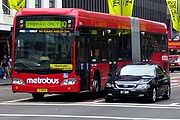 In October 2008, State Transit began a trial of a timetable-less high frequency bus route between Leichhardt
in the inner west and Kingsford
in the south-eastern suburbs via the CBD
. A combination of fixed body and bendy-buses in a red livery were provided for the service. On 14 October 2008, the Sydney Morning Herald revealed plans for several more metrobus routes across the inner city, numbered in the 10-100 series.
The Metrobus network include:
M10 - Leichhardt Bus Depot to Kingsford later extended to Maroubra Junction via, University of New South Wales, Anzac Pde, City, Broadway, University of Sydney, Parramatta Rd and Leichhardt.
M20 - Gore Hill to Mascot Shops later extended to Botany Shops via, North Sydney, City, Central Station and Rosebery.
M30 - Spit Junction to Sydenham Station via, Military Rd, City, Railway Square, Newtown and Enmore.
M40 - Bondi Junction Interchange to Chatswood Interchange via, Oxford St, Paddington, Taylor Square, City, Freeway and Willoughby.
M41 - Macquarie Park to Hurstville via Top Ryde, Burwood and Bexley North.
M50 - Coogee to Drummoyne via, The Spot, The Royal Womans Hospital, Randwick, University of New South Wales, Central Station, City, Victoria Rd and Rozelle.
M52 - City-Circular Quay to Parramatta via, Victoria Rd, Top Ryde and West Ryde. The M52 replaces the old L20.
M54 - Parramatta to Macquarie Park via, Epping, Macquarie University and Centre.
M60 - Hornsby Interchange to Parramatta via Castle Hill. The M60 follows and replaces the 600 between Castle Hill and Parramatta.
M61 - Railway Square to Castle Hill Interchange via, City, Lane Cove Tunnel and M2 motorway. The M61 follows the 610X between City and Castle Hill.
M90 - Burwood to Liverpool via, Strathfield and Bankstown. The M90 replaces the old 900.
M91 - Parramatta to Hurstville via Bankstown.
M92 - Parramatta to Sutherland via Bankstown.
NOTE: The M10 to M54 are operated by Sydney Buses. The M60 and M61 are operated by Hillsbus. The M90 to M92 are operated by Veolia Transport.
. A complex array of all stops, express and limited-stops services are provided. Much of the network is modelled on Sydney's former tram network
, closed in 1961 in favour of a commuter bus system. 100 series services are operated by Sydney Buses
and Forest Coach Lines
. A number of 100 series buses serve interchanges at Warringah Mall and Manly Ferry Wharf.
Sydney Buses depots are located at Brookvale (V runs), Mona Vale (F runs) and Willoughby (M runs). Forest Coaches operates from Terrey Hills. Bus-only lanes are in operation at Burnt Bridge Creek Deviation, Balgowlah and Manly Road, Balgowlah.
Route 144 has the distinction of being the first government-operated bus route in Sydney. Services commenced between Manly Wharf and Cremorne Junction on 25 December 1932, connecting with tram services
at Cremorne Junction. Buses were initially hired from White Transit Company at Naremburn
. The service was an instant success with over 2000 passengers carried on the first day alone. In October 1931, government legislation prevented the operation of private bus services in competition with government owned tram services. As private operators could not survive as feeders only to the trams
and trains
, they ceased operation. This allowed the government to lease excess stock from the private operators when services began from 1932. By the 1960s, the 144 had been extended to St Leonards, and later to Chatswood.
On the 2nd of August 2009, State transit implemented changes on this network including direct services Between Cromer Heights/War Verterns Home, and the City, new services to Elanora Heights, an extension to Warringah Mall for Route 135, and the withdrawal of some services like routes 146, 152, 172, E72, E73, & 193 plus more changes to various routes within the region.
regions with the central business district
are numbered in the 200 series. There are 62 routes, numbered 200 through 297. Express and limited-stops services are also provided. Much of the network is modelled on Sydney's former tram network
, closed in 1961 in favour of a commuter bus system. 200 series services are operated by Sydney Buses
and Forest Coach Lines
.
The major bus interchanges in this region are located at Chatswood Interchange, part of Chatswood railway station, Lane Cove, and stands in Blue Street, Miller Street and the Pacific Highway in North Sydney
.
In general, citybound 200 series buses terminate at the Queen Victoria Building
(near Town Hall railway station) and operate via the bus/rail interchange above Wynyard station
. In general, 200 series buses operate from Sydney Buses depots at Willoughby (M runs), North Sydney (N runs) and Ryde (Y runs); and the Forest Coach Lines depot at Terrey Hills. Route 200 operates from Waverley depot (W runs) near the line's southern terminus in the Eastern Suburbs. Bus-only lanes have been installed on the Warringah Freeway, Epping Road, North Sydney and Military Road, Neutral Bay
as well as on a southbound lane of the Sydney Harbour Bridge
.
. Express and limited-stops services are also provided numbered in the X and L series. Much of the network is modelled on Sydney's former tram network
which closed in 1961 in favour of a commuter bus system. Given their high density, Sydney
's eastern suburbs have a significant public transport infrastructure in place. A bus-only roadway uses the old tramway alignment to speed buses through Moore Park
and Centennial Park. A bus-only tunnel at Edgecliff
gives buses priority access from New South Head Road to the terminal above the railway station. Bus-only lanes are in place on Anzac Parade
and Oxford Street
, two of the region's main roads.
State Transit maintains two major bus interchanges, located above Edgecliff railway station and Bondi Junction railway station. Another interchange is located within the Westfield Eastgardens
shopping centre complex in Pagewood. Other significant nodes include Randwick
Junction, Kingsford
Nine Ways, Bondi Beach and the University of New South Wales
. Bus depots serving the area are located at Port Botany (P runs), Randwick
(R runs) and Waverley
(W runs).
State Transit previously operated the Airport Express bus (numbered 300) in bright green and gold livery between the city and Sydney Airport. The service was withdrawn after the opening of the Airport rail link
to encourage passengers to use the new rail line, given that the NSW government was obliged to pay compensation to the Airport Link Company if patronage targets were not met.
Services through the troubled inner-city neighbourhood of Redfern
have been diverted on occasion due to people throwing rocks and other projectiles at buses.
The 370 service, linking Coogee Beach and Leichhardt via Newtown, Glebe and the universities of New South Wales and Sydney.
In 2008, State Transit released a proposal to reorganise some bus routes around the Green Square area, involving routes 301, 302, 303, 311, 343, X43, 357, & 359, ., and the results were that there were to be some changes to some of those services but the biggest change is that Route 348 has now been altered to operate a Weekday Daytime service and at the same time, extended to Wolli Creek via Rosebery.
Route 380 operates from North Bondi to Circular Quay through some of Sydney's most densley populated neighbourhoods. It replaced the famous Bondi Tram
which closed in 1960. Additional services operate to and from Dover Heights
and Watsons Bay
. In 2002, a diversion along Denham and Dudley Streets in Bondi was eliminated under the Better Buses programme. The 380 now operates directly along Bondi Road.
Route 381 is a supplement to the 380, consisting of short workings of the 380 between Bondi and Bondi Junction. It was introduced in 2001, and maintains a diversion along Denham and Dudley Streets in Bondi, which was removed from the 380 in 2002.
Route 382 is a variant of the 381, consisting of Friday night workings between Bondi Beach and Bondi Junction along Bondi Road, in lieu of the Denham and Dudley Streets diversion, This service also provides extra services during the Spring and Summer times especially during special events at Bondi Beach.
Route 333 is State Transits first 'Prepay Only' limited stops service which parallels the 380. It was introduced in 2006 and is operated by articulated buses based in Waverley bus depot.
Passengers are required to purchase tickets before boarding the bus in order to reduce loading times and speed up the service. Buses serving route 333 are outfitted with special removable "prepay only" signage. The 333 replaced many of the timetable's 380 services. Passengers paying cash extend loading times significantly, and 380 passengers, many of them tourists, are twice as likely to use cash. Former Roads and Traffic Authority of New South Wales chief Ken Dobinson told the Sydney Morning Herald that the cashless bus route was a "half measure" and suggested that cashless routes would be used to improve bus performance while the city waited for the overdue Tcard
system to be implemented.
Route X84 is an express bus route operating between North Bondi and Bondi Junction, travelling along Curlewis Street and Old South Head Road in lieu of Bondi Road. Several trips towards Bondi Junction operate on weekday mornings, and several trips operate the reverse journey in the evenings. This route was previously numbered 384 from its inception in 1979 until 1990 when it was renumbered X84. On September 2008 This is now Pre-Pay only so no tickets are sold on this service.
 Services in the Inner West district and part of the St George area of Sydney are numbered in the 400 series, and connect these suburbs and the central business district
. There are 70 routes are numbered 400 through 499. Express and limited-stops services are also provided. Much of the network in the Inner West is modelled on Sydney's former tram network
, closed in 1961 in favour of a commuter bus system. 400 series services are operated by Sydney Buses
, Punchbowl Bus Company
, and Veolia. Bus-rail interchanges are provided at Hurstville station, Rockdale station and Strathfield station. Bus-only lanes are in operation on Parramatta Road from Leichhardt to Broadway.
regions, and the central business district
are numbered in the 500 series. Fifty-nine routes are numbered 500 through 597. Express and limited-stops services are also provided.
Much of the network is modelled on Sydney's former tram network
, closed in 1961 in favour of a commuter bus system. 500 series services are operated by Sydney Buses
from a depot at Ryde, and Shorelink
from a depot at Mount Ku-ring-gai. Acquisitions in the 1990s saw Sydney Buses expand its presence in this region significantly.
Bus interchanges are located at Hornsby and West Ryde railway stations, Blaxland Road, Top Ryde
, and at Parramatta. Victoria Road, the key link between Ryde and the city, has Transit Lanes in both directions. A proposal to change these to bus-only lanes is under consideration.
are numbered in the 600 series. A small number of 600 series bus routes (routes 688 to 698) are operated in the Blue Mountains and the Penrith area by the Blue Mountains Bus Company. Approximately 82 routes are numbered 600 through 698.
600 series services are operated by Hillsbus, Westbus, Hawkesbury Valley Buses and the Blue Mountains Bus Company.
Hillsbus also operates high frequency Metrobus services within the area, connecting Castle Hill and Baulkham Hills with Hornsby and Parramatta (route M60), and Sydney CBD (route M61).
Many suburbs in this area are served by the North-West T-way
, a bus rapid transit
service operated by Busways and Hillsbus. Bus-only lanes have recently been added to Epping Road as part of the Lane Cove Tunnel
roadworks.
City "X" services operate via the Lane Cove Tunnel. They do not stop along Epping Road and mainly run during peak hours.
and the Hills District with Blacktown
, Castle Hill
, Mount Druitt
, Parramatta
, St Marys
and Penrith
are numbered in the 700 series. Seventy routes are numbered in the 700 series. 700 series services are operated by Busways, Hillsbus and Westbus.
The Western Sydney bus network operates from interchanges at Blacktown
, Mount Druitt
, Parramatta
and Penrith
. For information regarding services north and east of Blacktown that connect with Rouse Hill and Castle Hill please refer to the North-West T-way
article.
, Busways, Interline
, Metro-Link
and Westbus.
Bus transport in the area began in 1934 with a single bus service linking Liverpool
and Green Valley
. Today's 41 routes serve a denser, more urban region. Significant change for the region's bus network came with the Unsworth
bus reforms. Initiated in 2004, these changes have put pressure on private bus operators to consolidate or co-operate in order to service amalgamated operating regions.
Busabout and Interline have announced their plans to bid jointly to provide services in the area. For its part, Westbus parent ComfortDelGro Cabcharge, has lately acquired a number of smaller operators, including routes 810 through 815 from Baxter's Bus Lines.
Campbelltown City Council facilitates a community public transport forum, which allows community leaders and council to liaise directly with bus operators, CityRail
and the Roads & Traffic Authority. The council and community groups have distributed 90,000 Macarthur
Transport Info Cards, providing information on local public transport options.
The south-western bus network operates from interchanges at Liverpool
, Campbelltown interchange and Macarthur Square
shopping centre. Many suburbs in this area are served by the Liverpool-Parramatta T-way
, a bus rapid transit
service operated by Western Sydney Buses
. The region is not presently served by significant bus-only lane infrastructure.
900 series services are operated by BusLink
, Maianbar and Bundeena Bus Service, Punchbowl Bus Company
and Veolia.
Sydney
Sydney is the most populous city in Australia and the state capital of New South Wales. Sydney is located on Australia's south-east coast of the Tasman Sea. As of June 2010, the greater metropolitan area had an approximate population of 4.6 million people...
, Australia
Australia
Australia , officially the Commonwealth of Australia, is a country in the Southern Hemisphere comprising the mainland of the Australian continent, the island of Tasmania, and numerous smaller islands in the Indian and Pacific Oceans. It is the world's sixth-largest country by total area...
are generally numbered with three digits, the first digit referring to the region in which the bus route primarily operates.
Metrobus
Leichhardt, New South Wales
Leichhardt is a suburb in the inner-west of Sydney in New South Wales, Australia. Leichhardt is located 5 kilometres west of the Sydney central business district and is the administrative centre for the local government area of the Municipality of Leichhardt...
in the inner west and Kingsford
Kingsford, New South Wales
Kingsford is a suburb in south-eastern Sydney, in the state of New South Wales, Australia. Kingsford is located 7 kilometres south-east of the Sydney central business district, in the local government area of the City of Randwick...
in the south-eastern suburbs via the CBD
Sydney
Sydney is the most populous city in Australia and the state capital of New South Wales. Sydney is located on Australia's south-east coast of the Tasman Sea. As of June 2010, the greater metropolitan area had an approximate population of 4.6 million people...
. A combination of fixed body and bendy-buses in a red livery were provided for the service. On 14 October 2008, the Sydney Morning Herald revealed plans for several more metrobus routes across the inner city, numbered in the 10-100 series.
The Metrobus network include:
M10 - Leichhardt Bus Depot to Kingsford later extended to Maroubra Junction via, University of New South Wales, Anzac Pde, City, Broadway, University of Sydney, Parramatta Rd and Leichhardt.
M20 - Gore Hill to Mascot Shops later extended to Botany Shops via, North Sydney, City, Central Station and Rosebery.
M30 - Spit Junction to Sydenham Station via, Military Rd, City, Railway Square, Newtown and Enmore.
M40 - Bondi Junction Interchange to Chatswood Interchange via, Oxford St, Paddington, Taylor Square, City, Freeway and Willoughby.
M41 - Macquarie Park to Hurstville via Top Ryde, Burwood and Bexley North.
M50 - Coogee to Drummoyne via, The Spot, The Royal Womans Hospital, Randwick, University of New South Wales, Central Station, City, Victoria Rd and Rozelle.
M52 - City-Circular Quay to Parramatta via, Victoria Rd, Top Ryde and West Ryde. The M52 replaces the old L20.
M54 - Parramatta to Macquarie Park via, Epping, Macquarie University and Centre.
M60 - Hornsby Interchange to Parramatta via Castle Hill. The M60 follows and replaces the 600 between Castle Hill and Parramatta.
M61 - Railway Square to Castle Hill Interchange via, City, Lane Cove Tunnel and M2 motorway. The M61 follows the 610X between City and Castle Hill.
M90 - Burwood to Liverpool via, Strathfield and Bankstown. The M90 replaces the old 900.
M91 - Parramatta to Hurstville via Bankstown.
M92 - Parramatta to Sutherland via Bankstown.
NOTE: The M10 to M54 are operated by Sydney Buses. The M60 and M61 are operated by Hillsbus. The M90 to M92 are operated by Veolia Transport.
Northern Beaches services (100 series)
69 bus routes numbered in the 100 series provide services between the Northern Beaches region of Sydney and the central business districtCity of Sydney
The City of Sydney is the Local Government Area covering the Sydney central business district and surrounding inner city suburbs of the greater metropolitan area of Sydney, Australia...
. A complex array of all stops, express and limited-stops services are provided. Much of the network is modelled on Sydney's former tram network
Trams in Sydney
The Sydney tramway network once served Sydney, the capital city of New South Wales, Australia. In its heyday, it was the largest in Australia, the second largest in the Commonwealth , and one of the largest in the world. It was extremely intensively worked, with about 1,600 cars in service at any...
, closed in 1961 in favour of a commuter bus system. 100 series services are operated by Sydney Buses
State Transit Authority of New South Wales
The State Transit Authority of New South Wales is an agency of the Government of New South Wales based in Sydney, Australia operating bus and ferry services. The STA is part of transport minister Gladys Berejiklian's portfolio...
and Forest Coach Lines
Forest coach lines
Forest Coach Lines is a company that operates bus services in the northern suburbs of Sydney, New South Wales, Australia.-Network:Metropolitan Bus Service Contract Region 14*194: St Ives – City...
. A number of 100 series buses serve interchanges at Warringah Mall and Manly Ferry Wharf.
Sydney Buses depots are located at Brookvale (V runs), Mona Vale (F runs) and Willoughby (M runs). Forest Coaches operates from Terrey Hills. Bus-only lanes are in operation at Burnt Bridge Creek Deviation, Balgowlah and Manly Road, Balgowlah.
Route 144 has the distinction of being the first government-operated bus route in Sydney. Services commenced between Manly Wharf and Cremorne Junction on 25 December 1932, connecting with tram services
Trams in Sydney
The Sydney tramway network once served Sydney, the capital city of New South Wales, Australia. In its heyday, it was the largest in Australia, the second largest in the Commonwealth , and one of the largest in the world. It was extremely intensively worked, with about 1,600 cars in service at any...
at Cremorne Junction. Buses were initially hired from White Transit Company at Naremburn
Naremburn, New South Wales
Naremburn is a suburb on the lower North Shore of Sydney, New South Wales, Australia. Naremburn is located 6 kilometres north of the Sydney central business district, in the local government area of the City of Willoughby.-History:...
. The service was an instant success with over 2000 passengers carried on the first day alone. In October 1931, government legislation prevented the operation of private bus services in competition with government owned tram services. As private operators could not survive as feeders only to the trams
Trams in Sydney
The Sydney tramway network once served Sydney, the capital city of New South Wales, Australia. In its heyday, it was the largest in Australia, the second largest in the Commonwealth , and one of the largest in the world. It was extremely intensively worked, with about 1,600 cars in service at any...
and trains
Railways in Sydney
Sydney, the largest city in Australia, has an extensive network of passenger and freight railways. The passenger network is a hybrid metro-suburban railway with a central underground core running at metro style frequencies, which branches out into a suburban commuter type network...
, they ceased operation. This allowed the government to lease excess stock from the private operators when services began from 1932. By the 1960s, the 144 had been extended to St Leonards, and later to Chatswood.
On the 2nd of August 2009, State transit implemented changes on this network including direct services Between Cromer Heights/War Verterns Home, and the City, new services to Elanora Heights, an extension to Warringah Mall for Route 135, and the withdrawal of some services like routes 146, 152, 172, E72, E73, & 193 plus more changes to various routes within the region.
North Shore services (200 series)
Services connecting Sydney's Northern Suburbs and North ShoreNorth Shore (Sydney)
The North Shore is an informal term used to describe the primarily residential area of northern metropolitan Sydney, in the state of New South Wales, Australia. The term usually refers to the suburbs located on the north shore of Sydney Harbour between Middle Harbour and the Lane Cove River, up to...
regions with the central business district
City of Sydney
The City of Sydney is the Local Government Area covering the Sydney central business district and surrounding inner city suburbs of the greater metropolitan area of Sydney, Australia...
are numbered in the 200 series. There are 62 routes, numbered 200 through 297. Express and limited-stops services are also provided. Much of the network is modelled on Sydney's former tram network
Trams in Sydney
The Sydney tramway network once served Sydney, the capital city of New South Wales, Australia. In its heyday, it was the largest in Australia, the second largest in the Commonwealth , and one of the largest in the world. It was extremely intensively worked, with about 1,600 cars in service at any...
, closed in 1961 in favour of a commuter bus system. 200 series services are operated by Sydney Buses
State Transit Authority of New South Wales
The State Transit Authority of New South Wales is an agency of the Government of New South Wales based in Sydney, Australia operating bus and ferry services. The STA is part of transport minister Gladys Berejiklian's portfolio...
and Forest Coach Lines
Forest coach lines
Forest Coach Lines is a company that operates bus services in the northern suburbs of Sydney, New South Wales, Australia.-Network:Metropolitan Bus Service Contract Region 14*194: St Ives – City...
.
The major bus interchanges in this region are located at Chatswood Interchange, part of Chatswood railway station, Lane Cove, and stands in Blue Street, Miller Street and the Pacific Highway in North Sydney
North Sydney, New South Wales
North Sydney is a suburb and commercial district on the Lower North Shore of Sydney, in the state of New South Wales, Australia. North Sydney is located 3 kilometres north of the Sydney central business district and is the administrative centre for the local government area of North Sydney...
.
In general, citybound 200 series buses terminate at the Queen Victoria Building
Queen Victoria Building
The Queen Victoria Building, or QVB, is a late nineteenth century building by the architect George McRae in the central business district of Sydney, Australia. The Romanesque Revival building is 30 metres wide by 190 metres long, and fills a city block, bounded by George, Market, York and Druitt...
(near Town Hall railway station) and operate via the bus/rail interchange above Wynyard station
Wynyard railway station, Sydney
Wynyard is a major underground CityRail station in the central business district of Sydney, Australia, 2.05 km from Central. Wynyard averages 108000 passenger movements per day Monday to Friday.-History:The station opened on 28 February 1932...
. In general, 200 series buses operate from Sydney Buses depots at Willoughby (M runs), North Sydney (N runs) and Ryde (Y runs); and the Forest Coach Lines depot at Terrey Hills. Route 200 operates from Waverley depot (W runs) near the line's southern terminus in the Eastern Suburbs. Bus-only lanes have been installed on the Warringah Freeway, Epping Road, North Sydney and Military Road, Neutral Bay
Neutral Bay, New South Wales
Neutral Bay is a harbourside suburb on the lower North Shore of Sydney, New South Wales, Australia. Neutral Bay is located 5 kilometres north of the Sydney central business district, in the local government area of North Sydney Council....
as well as on a southbound lane of the Sydney Harbour Bridge
Sydney Harbour Bridge
The Sydney Harbour Bridge is a steel through arch bridge across Sydney Harbour that carries rail, vehicular, bicycle and pedestrian traffic between the Sydney central business district and the North Shore. The dramatic view of the bridge, the harbour, and the nearby Sydney Opera House is an iconic...
.
Eastern Suburbs services (300 series)
Bus routes in Sydney's eastern suburbs are numbered in the 300 series. Seventy-one routes are numbered 301 through 399, all of which are operated by Sydney BusesState Transit Authority of New South Wales
The State Transit Authority of New South Wales is an agency of the Government of New South Wales based in Sydney, Australia operating bus and ferry services. The STA is part of transport minister Gladys Berejiklian's portfolio...
. Express and limited-stops services are also provided numbered in the X and L series. Much of the network is modelled on Sydney's former tram network
Trams in Sydney
The Sydney tramway network once served Sydney, the capital city of New South Wales, Australia. In its heyday, it was the largest in Australia, the second largest in the Commonwealth , and one of the largest in the world. It was extremely intensively worked, with about 1,600 cars in service at any...
which closed in 1961 in favour of a commuter bus system. Given their high density, Sydney
Sydney
Sydney is the most populous city in Australia and the state capital of New South Wales. Sydney is located on Australia's south-east coast of the Tasman Sea. As of June 2010, the greater metropolitan area had an approximate population of 4.6 million people...
's eastern suburbs have a significant public transport infrastructure in place. A bus-only roadway uses the old tramway alignment to speed buses through Moore Park
Moore Park, New South Wales
Moore Park is a large area of parkland in the Eastern Suburbs of Sydney, in the state of New South Wales, Australia. It is part of Centennial Parklands, a collective of three parks being Moore Park, Centennial Park and Queens Park. Centennial Parklands is administered by the Centennial Park &...
and Centennial Park. A bus-only tunnel at Edgecliff
Edgecliff
Edgecliff may refer to:* Edgecliff , historic building* Edgecliff College* Edgecliff Village, Texas* Edgecliff, New South Wales...
gives buses priority access from New South Head Road to the terminal above the railway station. Bus-only lanes are in place on Anzac Parade
Anzac Parade, Sydney
Anzac Parade is a major road in the south-eastern suburbs of Sydney, New South Wales, Australia. It included part of the marathon during the 2000 Summer Olympics, and the blue line denoting the marathon's path still exists today.-Description:...
and Oxford Street
Oxford Street, Sydney
Oxford Street is a major thoroughfare in Sydney, Australia running from Whitlam Square on the south-east corner of Hyde Park in the central business district of Sydney to Bondi Junction in the Eastern Suburbs. Close to the CBD in particular, the street is lined with numerous shops, bars and...
, two of the region's main roads.
State Transit maintains two major bus interchanges, located above Edgecliff railway station and Bondi Junction railway station. Another interchange is located within the Westfield Eastgardens
Westfield Eastgardens
Westfield Eastgardens is a shopping centre that is located in the suburb of Eastgardens in Sydney, New South Wales, Australia. The centre was the largest shopping centre in Australia when it opened in September 1987. The centre is owned by the Terrace Tower Group but operated and managed on a long...
shopping centre complex in Pagewood. Other significant nodes include Randwick
Randwick, New South Wales
Randwick is a suburb in south-eastern Sydney, in the state of New South Wales, Australia. Randwick is located 6 kilometres south-east of the Sydney central business district and is the administrative centre for the local government area of the City of Randwick...
Junction, Kingsford
Kingsford, New South Wales
Kingsford is a suburb in south-eastern Sydney, in the state of New South Wales, Australia. Kingsford is located 7 kilometres south-east of the Sydney central business district, in the local government area of the City of Randwick...
Nine Ways, Bondi Beach and the University of New South Wales
University of New South Wales
The University of New South Wales , is a research-focused university based in Kensington, a suburb in Sydney, New South Wales, Australia...
. Bus depots serving the area are located at Port Botany (P runs), Randwick
Randwick, New South Wales
Randwick is a suburb in south-eastern Sydney, in the state of New South Wales, Australia. Randwick is located 6 kilometres south-east of the Sydney central business district and is the administrative centre for the local government area of the City of Randwick...
(R runs) and Waverley
Waverley, New South Wales
Waverley is an eastern suburb of Sydney, in the state of New South Wales, Australia. Waverley is located 7 kilometres east of the Sydney central business district, in the local government area of Waverley Council....
(W runs).
State Transit previously operated the Airport Express bus (numbered 300) in bright green and gold livery between the city and Sydney Airport. The service was withdrawn after the opening of the Airport rail link
Airport Link Company
The Airport Link Company Pty Ltd operates the Green Square, Mascot, Airport Domestic and Airport International Train Stations. These stations are located in the nine kilometre Airport Line tunnel, which is 23 metres below the earth’s surface...
to encourage passengers to use the new rail line, given that the NSW government was obliged to pay compensation to the Airport Link Company if patronage targets were not met.
Services through the troubled inner-city neighbourhood of Redfern
Redfern, New South Wales
Redfern is an inner-city suburb of Sydney. Redfern is 3 kilometres south of the Sydney central business district and is part of the local government area of the City of Sydney...
have been diverted on occasion due to people throwing rocks and other projectiles at buses.
The 370 service, linking Coogee Beach and Leichhardt via Newtown, Glebe and the universities of New South Wales and Sydney.
In 2008, State Transit released a proposal to reorganise some bus routes around the Green Square area, involving routes 301, 302, 303, 311, 343, X43, 357, & 359, ., and the results were that there were to be some changes to some of those services but the biggest change is that Route 348 has now been altered to operate a Weekday Daytime service and at the same time, extended to Wolli Creek via Rosebery.
Bondi Beach services
Route 360 replaced the former Route 329. The 360 runs between North Clovelly and Bondi Junction InterchangeRoute 380 operates from North Bondi to Circular Quay through some of Sydney's most densley populated neighbourhoods. It replaced the famous Bondi Tram
Trams in Sydney
The Sydney tramway network once served Sydney, the capital city of New South Wales, Australia. In its heyday, it was the largest in Australia, the second largest in the Commonwealth , and one of the largest in the world. It was extremely intensively worked, with about 1,600 cars in service at any...
which closed in 1960. Additional services operate to and from Dover Heights
Dover Heights, New South Wales
Dover Heights is a coastal, eastern suburb of Sydney, in the state of New South Wales, Australia. Dover Heights is located 9 kilometres east of the Sydney central business district, in the local government area of Waverley Council...
and Watsons Bay
Watsons Bay, New South Wales
Watsons Bay is a harbourside, eastern suburb of Sydney, in the state of New South Wales, Australia. Watsons Bay is located 11 km north-east of the Sydney central business district, in the local government area of the Municipality of Woollahra....
. In 2002, a diversion along Denham and Dudley Streets in Bondi was eliminated under the Better Buses programme. The 380 now operates directly along Bondi Road.
Route 381 is a supplement to the 380, consisting of short workings of the 380 between Bondi and Bondi Junction. It was introduced in 2001, and maintains a diversion along Denham and Dudley Streets in Bondi, which was removed from the 380 in 2002.
Route 382 is a variant of the 381, consisting of Friday night workings between Bondi Beach and Bondi Junction along Bondi Road, in lieu of the Denham and Dudley Streets diversion, This service also provides extra services during the Spring and Summer times especially during special events at Bondi Beach.
Route 333 is State Transits first 'Prepay Only' limited stops service which parallels the 380. It was introduced in 2006 and is operated by articulated buses based in Waverley bus depot.
Passengers are required to purchase tickets before boarding the bus in order to reduce loading times and speed up the service. Buses serving route 333 are outfitted with special removable "prepay only" signage. The 333 replaced many of the timetable's 380 services. Passengers paying cash extend loading times significantly, and 380 passengers, many of them tourists, are twice as likely to use cash. Former Roads and Traffic Authority of New South Wales chief Ken Dobinson told the Sydney Morning Herald that the cashless bus route was a "half measure" and suggested that cashless routes would be used to improve bus performance while the city waited for the overdue Tcard
Tcard
Tcard was an integrated inter-modal stored-value ticketing project, similar to Hong Kong's Octopus Card system, originally intended to be in place before the 2000 Sydney Olympics. The project experienced many delays even before the contract was signed, due to a lawsuit brought by the losing bidder...
system to be implemented.
Route X84 is an express bus route operating between North Bondi and Bondi Junction, travelling along Curlewis Street and Old South Head Road in lieu of Bondi Road. Several trips towards Bondi Junction operate on weekday mornings, and several trips operate the reverse journey in the evenings. This route was previously numbered 384 from its inception in 1979 until 1990 when it was renumbered X84. On September 2008 This is now Pre-Pay only so no tickets are sold on this service.
Inner West and Inner South West services (400 series)
City of Sydney
The City of Sydney is the Local Government Area covering the Sydney central business district and surrounding inner city suburbs of the greater metropolitan area of Sydney, Australia...
. There are 70 routes are numbered 400 through 499. Express and limited-stops services are also provided. Much of the network in the Inner West is modelled on Sydney's former tram network
Trams in Sydney
The Sydney tramway network once served Sydney, the capital city of New South Wales, Australia. In its heyday, it was the largest in Australia, the second largest in the Commonwealth , and one of the largest in the world. It was extremely intensively worked, with about 1,600 cars in service at any...
, closed in 1961 in favour of a commuter bus system. 400 series services are operated by Sydney Buses
State Transit Authority of New South Wales
The State Transit Authority of New South Wales is an agency of the Government of New South Wales based in Sydney, Australia operating bus and ferry services. The STA is part of transport minister Gladys Berejiklian's portfolio...
, Punchbowl Bus Company
Punchbowl Bus Company
The Punchbowl Bus and Coach Company operates public buses in the south and inner south western suburbs of Sydney. It currently operates routes 446, 450, 939, 940, 941, 942, 943, 944, 945, 946, 953, 954, 955 and various school specials...
, and Veolia. Bus-rail interchanges are provided at Hurstville station, Rockdale station and Strathfield station. Bus-only lanes are in operation on Parramatta Road from Leichhardt to Broadway.
North-Western Suburbs services (500 series)
Services connecting Sydney's Northern Suburbs, upper North ShoreNorth Shore (Sydney)
The North Shore is an informal term used to describe the primarily residential area of northern metropolitan Sydney, in the state of New South Wales, Australia. The term usually refers to the suburbs located on the north shore of Sydney Harbour between Middle Harbour and the Lane Cove River, up to...
regions, and the central business district
City of Sydney
The City of Sydney is the Local Government Area covering the Sydney central business district and surrounding inner city suburbs of the greater metropolitan area of Sydney, Australia...
are numbered in the 500 series. Fifty-nine routes are numbered 500 through 597. Express and limited-stops services are also provided.
Much of the network is modelled on Sydney's former tram network
Trams in Sydney
The Sydney tramway network once served Sydney, the capital city of New South Wales, Australia. In its heyday, it was the largest in Australia, the second largest in the Commonwealth , and one of the largest in the world. It was extremely intensively worked, with about 1,600 cars in service at any...
, closed in 1961 in favour of a commuter bus system. 500 series services are operated by Sydney Buses
State Transit Authority of New South Wales
The State Transit Authority of New South Wales is an agency of the Government of New South Wales based in Sydney, Australia operating bus and ferry services. The STA is part of transport minister Gladys Berejiklian's portfolio...
from a depot at Ryde, and Shorelink
Shorelink
Shorelink is a commuter bus company serving suburbs on the upper North Shore of Sydney, Australia. On 3 September 2001, the company was acquired by French public transport giant Transdev from the John A Gilbert group, forming a partnership with Transfield Services Limited in 2009...
from a depot at Mount Ku-ring-gai. Acquisitions in the 1990s saw Sydney Buses expand its presence in this region significantly.
Bus interchanges are located at Hornsby and West Ryde railway stations, Blaxland Road, Top Ryde
Ryde, New South Wales
Ryde is a suburb of Sydney, New South Wales, Australia. Ryde is located 13 km north-west of the Sydney central business district and 8 km east of Parramatta. Ryde is the administrative centre of the local government area of the City of Ryde and part of the Northern Suburbs area...
, and at Parramatta. Victoria Road, the key link between Ryde and the city, has Transit Lanes in both directions. A proposal to change these to bus-only lanes is under consideration.
Hills District services (600 series)
Services connecting Sydney's Hills District with Parramatta and the cityCity of Sydney
The City of Sydney is the Local Government Area covering the Sydney central business district and surrounding inner city suburbs of the greater metropolitan area of Sydney, Australia...
are numbered in the 600 series. A small number of 600 series bus routes (routes 688 to 698) are operated in the Blue Mountains and the Penrith area by the Blue Mountains Bus Company. Approximately 82 routes are numbered 600 through 698.
600 series services are operated by Hillsbus, Westbus, Hawkesbury Valley Buses and the Blue Mountains Bus Company.
Hillsbus also operates high frequency Metrobus services within the area, connecting Castle Hill and Baulkham Hills with Hornsby and Parramatta (route M60), and Sydney CBD (route M61).
Many suburbs in this area are served by the North-West T-way
North-West T-way
The North-West T-way is a bus rapid transit line in the north-western suburbs of Sydney, Australia. T-way is short for rapid bus transitway.The T-way consists of two sections, one linking Parramatta railway station and Rouse Hill, the other linking Blacktown and Parklea. The lines intersect at...
, a bus rapid transit
Bus rapid transit
Bus rapid transit is a term applied to a variety of public transportation systems using buses to provide faster, more efficient service than an ordinary bus line. Often this is achieved by making improvements to existing infrastructure, vehicles and scheduling...
service operated by Busways and Hillsbus. Bus-only lanes have recently been added to Epping Road as part of the Lane Cove Tunnel
Lane Cove Tunnel
The Lane Cove Tunnel is a A$1.1 billion, 3.6 km twin tunnel tollway in Sydney, Australia, connecting the M2 Motorway at North Ryde with the Gore Hill Freeway at Artarmon. It forms part of Sydney Metroad 2 and the 110 km Sydney Orbital Network...
roadworks.
City "X" services operate via the Lane Cove Tunnel. They do not stop along Epping Road and mainly run during peak hours.
Outer Western services (700 series)
Services connecting Sydney's western suburbsWestern Sydney
Western Sydney is a major region of Sydney, Australia. It has a number of different definitions but one consistently used is the region composed of the 11 councils which until recently were all members of the Western Sydney Regional Organisation of Councils:* Auburn Council* Bankstown City Council*...
and the Hills District with Blacktown
Blacktown, New South Wales
Blacktown is a suburb in the City of Blacktown, in Western Sydney, in the state of New South Wales, Australia. Blacktown is located 34 kilometres west of the Sydney central business district and is the administrative centre of the local government area of City of Blacktown.Blacktown is the largest...
, Castle Hill
Castle Hill, New South Wales
Castle Hill is a suburb in the north-west of Sydney, in the state of New South Wales, Australia. Castle Hill is located 31 kilometres north-west of the Sydney central business district, in the Hills District of the Greater Western Sydney region...
, Mount Druitt
Mount Druitt, New South Wales
Mount Druitt is a suburb of Sydney, in the state of New South Wales, Australia. Mount Druitt is located 43 kilometres west of the Sydney central business district, in the local government area of the City of Blacktown, and is part of the Greater Western Sydney region.There are numerous...
, Parramatta
Parramatta, New South Wales
Parramatta is a suburb of Sydney, in the state of New South Wales, Australia. It is located in Greater Western Sydney west of the Sydney central business district on the banks of the Parramatta River. Parramatta is the administrative seat of the Local Government Area of the City of Parramatta...
, St Marys
St Marys, New South Wales
St Marys is a suburb in western Sydney, in the state of New South Wales Australia. St Marys is located 45 kilometres west of the Sydney central business district, in the local government area of the City of Penrith....
and Penrith
Penrith, New South Wales
Penrith is a suburb in western Sydney, in the state of New South Wales, Australia. Penrith is located west of the Sydney central business district and is the administrative centre for the local government area of the City of Penrith...
are numbered in the 700 series. Seventy routes are numbered in the 700 series. 700 series services are operated by Busways, Hillsbus and Westbus.
The Western Sydney bus network operates from interchanges at Blacktown
Blacktown, New South Wales
Blacktown is a suburb in the City of Blacktown, in Western Sydney, in the state of New South Wales, Australia. Blacktown is located 34 kilometres west of the Sydney central business district and is the administrative centre of the local government area of City of Blacktown.Blacktown is the largest...
, Mount Druitt
Mount Druitt, New South Wales
Mount Druitt is a suburb of Sydney, in the state of New South Wales, Australia. Mount Druitt is located 43 kilometres west of the Sydney central business district, in the local government area of the City of Blacktown, and is part of the Greater Western Sydney region.There are numerous...
, Parramatta
Parramatta, New South Wales
Parramatta is a suburb of Sydney, in the state of New South Wales, Australia. It is located in Greater Western Sydney west of the Sydney central business district on the banks of the Parramatta River. Parramatta is the administrative seat of the Local Government Area of the City of Parramatta...
and Penrith
Penrith, New South Wales
Penrith is a suburb in western Sydney, in the state of New South Wales, Australia. Penrith is located west of the Sydney central business district and is the administrative centre for the local government area of the City of Penrith...
. For information regarding services north and east of Blacktown that connect with Rouse Hill and Castle Hill please refer to the North-West T-way
North-West T-way
The North-West T-way is a bus rapid transit line in the north-western suburbs of Sydney, Australia. T-way is short for rapid bus transitway.The T-way consists of two sections, one linking Parramatta railway station and Rouse Hill, the other linking Blacktown and Parklea. The lines intersect at...
article.
South Western Suburbs services (800 series)
Services connecting Sydney's south-west are numbered in the 800 series. Forty-one south western routes are provided. 800 series services are operated by BusaboutBusabout
Busabout is a company that operates bus services in the western suburbs of Sydney, New South Wales, Australia. It has a depot at Hoxton Park and provides services in the Liverpool area. The company was previously known as Neville's Bus Service which commenced operations in 1947...
, Busways, Interline
Interline Bus Services
-Interline Bus Service:Interline Bus Services is a local family company with 50 years experience in the provision of bus services in Campbelltown and Liverpool...
, Metro-Link
Metro-link Bus Lines
Oliveri's Metro-link Bus Lines is a family run bus company that operates bus services in the south-western suburbs of Sydney, New South Wales. It has a depot at Green Valley and provides services in the Green Valley to Liverpool area. The company was established in 1954 by the Oliveri family,...
and Westbus.
Bus transport in the area began in 1934 with a single bus service linking Liverpool
Liverpool, New South Wales
Liverpool is a suburb in south-western Sydney, in the state of New South Wales, Australia. Liverpool is located 32 km south-west of the Sydney central business district, and is the administrative centre of the local government area of the City of Liverpool...
and Green Valley
Green Valley, New South Wales
Green Valley is a suburb of Sydney, in the state of New South Wales, Australia. Green Valley is located 39 kilometres west of the Sydney central business district, in the local government area of the City of Liverpool and is part of the Greater Western Sydney region.-History:Green Valley was...
. Today's 41 routes serve a denser, more urban region. Significant change for the region's bus network came with the Unsworth
Barrie Unsworth
Barrie John Unsworth was an Australian politician, representing the Australian Labor Party in the Parliament of New South Wales from 1978 to 1991. He served as the 36th Premier from July 1986 to March 1988.-Early years:...
bus reforms. Initiated in 2004, these changes have put pressure on private bus operators to consolidate or co-operate in order to service amalgamated operating regions.
Busabout and Interline have announced their plans to bid jointly to provide services in the area. For its part, Westbus parent ComfortDelGro Cabcharge, has lately acquired a number of smaller operators, including routes 810 through 815 from Baxter's Bus Lines.
Campbelltown City Council facilitates a community public transport forum, which allows community leaders and council to liaise directly with bus operators, CityRail
CityRail
CityRail is an operating brand of RailCorp, a corporation owned by the state government of New South Wales, Australia. It is responsible for providing commuter rail services, and some coach services, in and around Sydney, Newcastle and Wollongong, the three largest cities of New South Wales. It is...
and the Roads & Traffic Authority. The council and community groups have distributed 90,000 Macarthur
Transport Info Cards, providing information on local public transport options.
The south-western bus network operates from interchanges at Liverpool
Liverpool, New South Wales
Liverpool is a suburb in south-western Sydney, in the state of New South Wales, Australia. Liverpool is located 32 km south-west of the Sydney central business district, and is the administrative centre of the local government area of the City of Liverpool...
, Campbelltown interchange and Macarthur Square
Macarthur Square
Macarthur Square is a large shopping centre on the southern side of Campbelltown, New South Wales, Australia. The shopping centre is owned by the Lend Lease Corporation and GPT...
shopping centre. Many suburbs in this area are served by the Liverpool-Parramatta T-way
Liverpool-Parramatta T-way
The Liverpool-Parramatta T-way is a bus rapid transit line in the western suburbs of Sydney, Australia. "T-way" is short for rapid bus transitway.- Route and services :...
, a bus rapid transit
Bus rapid transit
Bus rapid transit is a term applied to a variety of public transportation systems using buses to provide faster, more efficient service than an ordinary bus line. Often this is achieved by making improvements to existing infrastructure, vehicles and scheduling...
service operated by Western Sydney Buses
State Transit Authority of New South Wales
The State Transit Authority of New South Wales is an agency of the Government of New South Wales based in Sydney, Australia operating bus and ferry services. The STA is part of transport minister Gladys Berejiklian's portfolio...
. The region is not presently served by significant bus-only lane infrastructure.
Southern Suburbs services (900 series)
Services connecting Sydney's southern suburbs (Part of the St George area, the Sutherland Shire and parts of the Bankstown and Liverpool areas) are numbered in the 900 series. Around 60 routes are numbered 900 through 996. Express and limited-stops services are also provided.900 series services are operated by BusLink
BusLink
Crowthers is a family-owned bus company that operates charter coach services, and until the end of 2008, operated local bus services in the southern suburbs of Sydney, New South Wales, Australia.-History of service:...
, Maianbar and Bundeena Bus Service, Punchbowl Bus Company
Punchbowl Bus Company
The Punchbowl Bus and Coach Company operates public buses in the south and inner south western suburbs of Sydney. It currently operates routes 446, 450, 939, 940, 941, 942, 943, 944, 945, 946, 953, 954, 955 and various school specials...
and Veolia.
External links
- Transport InfoLine - Timetable and fare information