
Buckhorn Wilderness
Encyclopedia
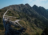
The Buckhorn Wilderness is a 44258 acres (179.1 km²) mountain
ous wilderness area on the northeastern Olympic Peninsula
in Washington, USA
. Named after Buckhorn Mountain (6988 ft (2,129.9 m)), the wilderness abuts the eastern boundary of Olympic National Park
which includes nearby Mount Constance
(7756 ft (2,364 m)), Inner Constance (7667 ft (2,336.9 m)), Warrior Peak (7320 ft (2,231.1 m)), and Mount Deception
(7788 ft (2,373.8 m)).
 The Buckhorn Wilderness, established in 1984, is the largest of the five wilderness areas surrounding the Olympic Wilderness
within Olympic National Park. The others are:
The Buckhorn Wilderness is administered by the Hood Canal Ranger District of the Olympic National Forest
.
s of the Buckhorn Wilderness are found in the lower parts of the three principal drainage
s: 2470 feet (752.9 m) at the Big Quilcene River
, 2700 feet (823 m) at the Dungeness River
, and 3300 feet (1,005.8 m) at Townsend Creek. The highest point in the wilderness is 7139 feet (2,176 m) at the summit of Mount Fricaba, which lies on the western boundary of the wilderness area, shared by Olympic National Park. The tallest peak entirely within the wilderness is Buckhorn Mountain at 6988 feet (2,129.9 m). A notable historical site in the Buckhorn Wilderness is the Tubal Cain mine
.
of the Olympic Range, resulting in a relatively drier climate
. Despite this, the lowland forests (below about 4,000 feet) are still dominated by stands of old-growth western red cedar, western hemlock
, and Douglas-fir
, in addition to numerous understory organisms such as devil's club
, salal
, thimbleberry
, fungi
, and moss
es. Above about 6000 feet (1,828.8 m), alpine vegetation
prevails where conditions are not too dry. Some slopes, such as the south side of Buckhorn Mountain, are rather arid
above tree line due to fast-draining soil
s, sunny exposure, and low precipitation in the summer months.
Mountain
Image:Himalaya_annotated.jpg|thumb|right|The Himalayan mountain range with Mount Everestrect 58 14 160 49 Chomo Lonzorect 200 28 335 52 Makalurect 378 24 566 45 Mount Everestrect 188 581 920 656 Tibetan Plateaurect 250 406 340 427 Rong River...
ous wilderness area on the northeastern Olympic Peninsula
Olympic Peninsula
The Olympic Peninsula is the large arm of land in western Washington state of the USA, that lies across Puget Sound from Seattle. It is bounded on the west by the Pacific Ocean, the north by the Strait of Juan de Fuca, and the east by Puget Sound. Cape Alava, the westernmost point in the contiguous...
in Washington, USA
United States
The United States of America is a federal constitutional republic comprising fifty states and a federal district...
. Named after Buckhorn Mountain (6988 ft (2,129.9 m)), the wilderness abuts the eastern boundary of Olympic National Park
Olympic National Park
Olympic National Park is located in the U.S. state of Washington, in the Olympic Peninsula. The park can be divided into four basic regions: the Pacific coastline, alpine areas, the west side temperate rainforest and the forests of the drier east side. U.S...
which includes nearby Mount Constance
Mount Constance
Mount Constance is a peak in the Olympic Mountains of Washington and the third highest in the range. It is the most visually prominent peak on Seattle's western skyline. Despite being almost as tall as the ice-clad Mount Olympus to the west, Mount Constance has little in the way of glaciers and...
(7756 ft (2,364 m)), Inner Constance (7667 ft (2,336.9 m)), Warrior Peak (7320 ft (2,231.1 m)), and Mount Deception
Mount Deception
Mount Deception is a peak in the Olympic Mountains in the U.S. state of Washington. It is in Olympic National Park on the Olympic Peninsula.- Description :...
(7788 ft (2,373.8 m)).
Administration
Olympic Wilderness
Olympic Wilderness is a protected area comprising over 95% of Olympic National Park in Washington State. It includes of Pacific Ocean coastline. It is the largest wilderness area in Washington.- External links :* * *...
within Olympic National Park. The others are:
- The Brothers WildernessThe Brothers WildernessThe Brothers Wilderness area is located in the Olympic National Forest on the eastern side of the Olympic Peninsula south of Buckhorn Wilderness and north of Mt. Skokomish Wilderness. The area was created in 1984 and now includes . The Brothers wilderness is named after The Brothers peaks which...
- Colonel Bob WildernessColonel Bob WildernessColonel Bob Wilderness is a 48 km2 protected area located in the southwest corner of Olympic National Forest in Washington State. It is named after 19th century orator Robert Green Ingersoll. Lake Quinault lies about 15 miles to the west. Elevations in the wilderness vary from 300 to 4,509...
- Mount Skokomish WildernessMount Skokomish WildernessMount Skokomish Wilderness is a designated wilderness area in the Olympic National Forest on the Olympic Peninsula of Washington in the United States. The wilderness area was established in 1984 and comprises . It is administered by the US Forest Service....
- Wonder Mountain WildernessWonder Mountain WildernessWonder Mountain Wilderness is a designated wilderness area encompassing Wonder Mountain in the Olympic National Forest on the Olympic Peninsula of Washington in the United States. The wilderness was established in 1984 and comprises . It borders Olympic National Park and is administered by the US...
The Buckhorn Wilderness is administered by the Hood Canal Ranger District of the Olympic National Forest
Olympic National Forest
Olympic National Forest is a U.S. National Forest located in Washington, USA. With an area of 633,677 acres , it nearly surrounds Olympic National Park and the Olympic Mountain range. Olympic National Forest contains parts of Clallam, Grays Harbor, Jefferson, and Mason counties...
.
Geography
The lowest elevationElevation
The elevation of a geographic location is its height above a fixed reference point, most commonly a reference geoid, a mathematical model of the Earth's sea level as an equipotential gravitational surface ....
s of the Buckhorn Wilderness are found in the lower parts of the three principal drainage
Drainage basin
A drainage basin is an extent or an area of land where surface water from rain and melting snow or ice converges to a single point, usually the exit of the basin, where the waters join another waterbody, such as a river, lake, reservoir, estuary, wetland, sea, or ocean...
s: 2470 feet (752.9 m) at the Big Quilcene River
Big Quilcene River
The Big Quilcene River is a river on the Olympic Peninsula in the U.S. state of Washington. It rises in the Buckhorn Wilderness near Marmot Pass, south of Buckhorn Mountain, and near Mount Constance. It flows generally east through the Olympic Mountains and the Olympic National Forest. After...
, 2700 feet (823 m) at the Dungeness River
Dungeness River
The Dungeness River is a long river located in the Olympic Peninsula in the U.S. state of Washington. It rises near Mount Constance in the Olympic Mountains within the Olympic National Park, flows through the Buckhorn Wilderness, passes by the town of Sequim, and empties into the Strait of Juan de...
, and 3300 feet (1,005.8 m) at Townsend Creek. The highest point in the wilderness is 7139 feet (2,176 m) at the summit of Mount Fricaba, which lies on the western boundary of the wilderness area, shared by Olympic National Park. The tallest peak entirely within the wilderness is Buckhorn Mountain at 6988 feet (2,129.9 m). A notable historical site in the Buckhorn Wilderness is the Tubal Cain mine
Tubal Cain mine
Tubal Cain Mine is an abandoned copper mine in the Buckhorn Wilderness, east of Olympic National Park in the US state of Washington. The main adit penetrates 450 meters into Buckhorn Mountain....
.
Ecology
The wilderness lies within the rain shadowRain shadow
A rain shadow is a dry area on the lee side of a mountainous area. The mountains block the passage of rain-producing weather systems, casting a "shadow" of dryness behind them. As shown by the diagram to the right, the warm moist air is "pulled" by the prevailing winds over a mountain...
of the Olympic Range, resulting in a relatively drier climate
Climate
Climate encompasses the statistics of temperature, humidity, atmospheric pressure, wind, rainfall, atmospheric particle count and other meteorological elemental measurements in a given region over long periods...
. Despite this, the lowland forests (below about 4,000 feet) are still dominated by stands of old-growth western red cedar, western hemlock
Western Hemlock
Tsuga heterophylla. the Western Hemlock, is a species of hemlock native to the west coast of North America, with its northwestern limit on the Kenai Peninsula, Alaska, and its southeastern limit in northern Sonoma County, California.-Habitat:...
, and Douglas-fir
Douglas-fir
Douglas-fir is one of the English common names for evergreen coniferous trees of the genus Pseudotsuga in the family Pinaceae. Other common names include Douglas tree, and Oregon pine. There are five species, two in western North America, one in Mexico, and two in eastern Asia...
, in addition to numerous understory organisms such as devil's club
Devil's Club
Devil's Club is a large shrub primarily native to the cool moist forests of western North America, but also disjunct on islands in Lake Superior. It is noted for its large palmate leaves and erect, woody stems covered in brittle spines...
, salal
Salal
Gaultheria shallon is a leathery-leaved shrub in the heather family , native to western North America. In English it is known as salal, shallon, or in Britain simply Gaultheria.-Ecology:...
, thimbleberry
Thimbleberry
Rubus parviflorus, commonly called thimbleberry or salmonberry, is a species of Rubus, native to western and northern North America, from Alaska east to Ontario and Michigan, and south to northern Mexico...
, fungi
Fungus
A fungus is a member of a large group of eukaryotic organisms that includes microorganisms such as yeasts and molds , as well as the more familiar mushrooms. These organisms are classified as a kingdom, Fungi, which is separate from plants, animals, and bacteria...
, and moss
Moss
Mosses are small, soft plants that are typically 1–10 cm tall, though some species are much larger. They commonly grow close together in clumps or mats in damp or shady locations. They do not have flowers or seeds, and their simple leaves cover the thin wiry stems...
es. Above about 6000 feet (1,828.8 m), alpine vegetation
Tundra
In physical geography, tundra is a biome where the tree growth is hindered by low temperatures and short growing seasons. The term tundra comes through Russian тундра from the Kildin Sami word tūndâr "uplands," "treeless mountain tract." There are three types of tundra: Arctic tundra, alpine...
prevails where conditions are not too dry. Some slopes, such as the south side of Buckhorn Mountain, are rather arid
Semi-arid
A semi-arid climate or steppe climate describes climatic regions that receive precipitation below potential evapotranspiration, but not extremely...
above tree line due to fast-draining soil
Soil
Soil is a natural body consisting of layers of mineral constituents of variable thicknesses, which differ from the parent materials in their morphological, physical, chemical, and mineralogical characteristics...
s, sunny exposure, and low precipitation in the summer months.
External links
- Buckhorn Wilderness - Olympic National Forest
- Buckhorn Wilderness recreation opportunity guide - Olympic National Forest
- Buckhorn Wilderness - Wilderness.net
- Buckhorn Wilderness - GORP