

Broughton, Wrexham
Encyclopedia
Community (Wales)
A community is a division of land in Wales that forms the lowest-tier of local government in Wales. Welsh communities are analogous to civil parishes in England....
, the lowest tier of local government, part of Wrexham County Borough in Wales
Wales
Wales is a country that is part of the United Kingdom and the island of Great Britain, bordered by England to its east and the Atlantic Ocean and Irish Sea to its west. It has a population of three million, and a total area of 20,779 km²...
. It has an area of 469 hectares and had a population of 6,498 in the 2001 census
United Kingdom Census 2001
A nationwide census, known as Census 2001, was conducted in the United Kingdom on Sunday, 29 April 2001. This was the 20th UK Census and recorded a resident population of 58,789,194....
.
History
Broughton was recorded in the reign of Henry VIIHenry VII of England
Henry VII was King of England and Lord of Ireland from his seizing the crown on 22 August 1485 until his death on 21 April 1509, as the first monarch of the House of Tudor....
as one of the townships
Township (England)
In England, a township is a local division or district of a large parish containing a village or small town usually having its own church...
of the manor of Eglwysegle (a name preserved in the area known as Eglwyseg
Eglwyseg
The Eglwyseg valley is an area to the north east of Llangollen in Denbighshire, Wales; it is within the boundaries of Llantysilio Community. The name also refers to a widely-scattered hamlet in the valley....
near Llangollen
Llangollen
Llangollen is a small town and community in Denbighshire, north-east Wales, situated on the River Dee and on the edge of the Berwyn mountains. It has a population of 3,412.-History:...
), part of the lordship of Bromfield. The Wrexham
Wrexham
Wrexham is a town in Wales. It is the administrative centre of the wider Wrexham County Borough, and the largest town in North Wales, located in the east of the region. It is situated between the Welsh mountains and the lower Dee Valley close to the border with Cheshire, England...
historian Alfred Neobard Palmer
Alfred Neobard Palmer
Alfred Neobard Palmer was a chemist and local historian. He published several books concerning the local history of Wrexham and north Wales.-Biography:...
noted:
Three villages [called Broughton] are situated in that part of Wales which was settled by Englishmen. They appear in DomesdayDomesday BookDomesday Book , now held at The National Archives, Kew, Richmond upon Thames in South West London, is the record of the great survey of much of England and parts of Wales completed in 1086...
as "Brochetune" or "Broctune," which can hardly mean anything else than "Brook-town". The brook which may have given the Bromfield Broughton its name is now almost always dry, but "Rhyd Broughton" (or Broughton ford) preserves the memory of it.
Under the ecclesiastical administration the township of Broughton was part of the parish
Parish
A parish is a territorial unit historically under the pastoral care and clerical jurisdiction of one parish priest, who might be assisted in his pastoral duties by a curate or curates - also priests but not the parish priest - from a more or less central parish church with its associated organization...
of Wrexham, and later of Brymbo
Brymbo
Brymbo is a local government community, the lowest tier of local government, part of Wrexham County Borough in Wales. It is a village situated in the hilly country to the west of Wrexham town, largely surrounded by farmland....
. Population changes led to it being made a parish in its own right in 1909.
The corresponding civil parish
Civil parish
In England, a civil parish is a territorial designation and, where they are found, the lowest tier of local government below districts and counties...
of Broughton, which was ultimately based on the boundaries of the ancient township, became the community of Broughton under the terms of the Local Government Act 1972
Local Government Act 1972
The Local Government Act 1972 is an Act of Parliament in the United Kingdom that reformed local government in England and Wales on 1 April 1974....
. It today contains the villages of Moss, Pentre Broughton
Pentre Broughton
Pentre Broughton is a small, formerly industrial village in the community of Broughton in Wrexham county borough, Wales. It is contiguous with the neighbouring villages of Moss and Brynteg....
, Brynteg, New Broughton, Southsea and Caego
Caego
Caego is a small village in Wrexham county borough, Wales, immediately to the west of the town of Wrexham in the community of Broughton. It is contiguous with the neighbouring larger village of New Broughton; the main road passing through the centre of the village is the B5101...
. The majority of the villages date from the 19th century, when the area became heavily industrialised through coal mining
Coal mining
The goal of coal mining is to obtain coal from the ground. Coal is valued for its energy content, and since the 1880s has been widely used to generate electricity. Steel and cement industries use coal as a fuel for extraction of iron from iron ore and for cement production. In the United States,...
and its proximity to the Brymbo Steelworks; most of the mines were located in the area known as Moss Valley
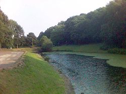
Moss Valley, Wrexham
The Moss Valley is an area and country park in Britain. It is in the county borough of Wrexham, in north Wales. The area is also informally known as "The Moss" and The Aggey amongst locals. It is most well known for its extensive coal mining history...
, along with a number in Pentre Broughton near Brymbo
Brymbo
Brymbo is a local government community, the lowest tier of local government, part of Wrexham County Borough in Wales. It is a village situated in the hilly country to the west of Wrexham town, largely surrounded by farmland....
such as the Brynmally and Pwll Cadi collieries.
Most of the area's coal mines had closed by the 1930s and the Moss Valley has now been reclaimed as a park. Continuing development has urbanised much of the rest of the community's area, with some agricultural land remaining in the south and east.