

Breña Baja
Encyclopedia
Breña Baja is a municipality on the eastern side of the island of La Palma
, in the province of Santa Cruz de Tenerife
, in the Canary Islands
. The ayuntamiento
(municipal office) is in the town of San José with an elevation of 300 m. Villa de Mazo lies on the main highway encircling the island, south of the capital Santa Cruz de la Palma
. Until the 17th century the area was known as Breña, but was then divided into Breña Alta
and Breña Baja.
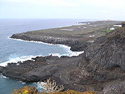
The coastline and the valley areas are made up of farmland, while the mountainous areas are forested or grassland in the central and northern parts but much of the area is deforested. Mountains dominate the coastline, giving panoramic views of La Gomera
to the southeast. The main industries were agriculture, especially wine
production, and fishing, but tourism has become the most important industry, with La Palma's second largest resort, Los Cancajos
, on the coast.
La Palma Airport
(formerly Mazo Airport) is located on the coast, in the south-east corner of Breña Baja, with a runway on partially reclaimed, land running parallel with the sea.
Other than a drop in 1920, the population has steadily increased.
The 1991 and 2001 figures, taken from the census, are lower than the surrounding figures, taken from municipal records.
s.
La Palma
La Palma is the most north-westerly of the Canary Islands. La Palma has an area of 706 km2 making it the fifth largest of the seven main Canary Islands...
, in the province of Santa Cruz de Tenerife
Santa Cruz de Tenerife
Santa Cruz de Tenerife is the capital , second-most populous city of the Autonomous Community of the Canary Islands and the 21st largest city in Spain, with a population of 222,417 in 2009...
, in the Canary Islands
Canary Islands
The Canary Islands , also known as the Canaries , is a Spanish archipelago located just off the northwest coast of mainland Africa, 100 km west of the border between Morocco and the Western Sahara. The Canaries are a Spanish autonomous community and an outermost region of the European Union...
. The ayuntamiento
Ayuntamiento
Ayuntamiento In other languages of Spain:*Catalan/Valencian .*Galician .*Basque . is the general term for the council of a municipality, or sometimes the municipality itself, in Spain and Latin America. Historically Ayuntamiento was often preceded by the word excelentísimo , when referring to...
(municipal office) is in the town of San José with an elevation of 300 m. Villa de Mazo lies on the main highway encircling the island, south of the capital Santa Cruz de la Palma
Santa Cruz de La Palma
Santa Cruz de la Palma is located on the eastern part of the island of La Palma in the province of Santa Cruz de Tenerife of the Canary Islands. Santa Cruz de la Palma is the second largest city and is the capital of the island...
. Until the 17th century the area was known as Breña, but was then divided into Breña Alta
Breña Alta
Breña Alta is a municipality on the eastern side of the island of La Palma, in the province of Santa Cruz de Tenerife, in the Canary Islands. The ayuntamiento is in the town of San Pedro, at 350 m above sea-level, and only 9 km south of the island's capital Santa Cruz de la Palma...
and Breña Baja.
The coastline and the valley areas are made up of farmland, while the mountainous areas are forested or grassland in the central and northern parts but much of the area is deforested. Mountains dominate the coastline, giving panoramic views of La Gomera
La Gomera
La Gomera is one of Spain's Canary Islands, located in the Atlantic Ocean off the coast of Africa. In area, it is the second-smallest of the seven main islands of this group.- Political organization :...
to the southeast. The main industries were agriculture, especially wine
Wine
Wine is an alcoholic beverage, made of fermented fruit juice, usually from grapes. The natural chemical balance of grapes lets them ferment without the addition of sugars, acids, enzymes, or other nutrients. Grape wine is produced by fermenting crushed grapes using various types of yeast. Yeast...
production, and fishing, but tourism has become the most important industry, with La Palma's second largest resort, Los Cancajos
Los Cancajos
Los Cancajos, also known as Playa de Los Cancajos, is a tourist resort in the Canarian island of La Palma. It is the second largest resort on the island, after Puerto Naos.-Location:...
, on the coast.
La Palma Airport
La Palma Airport
La Palma Airport is an airport located in Breña Baja and Villa de Mazo, south of the city of Santa Cruz de La Palma on La Palma in the Canary Islands. It is operated by Aeropuertos Españoles y Navegación Aérea, who operate the vast majority of civil airports in Spain...
(formerly Mazo Airport) is located on the coast, in the south-east corner of Breña Baja, with a runway on partially reclaimed, land running parallel with the sea.
Subdivisions
The municipality has 8 subdivisions, or "parishes" (population figures from 2005):- San Antonio (1,128 persons)
- San José (1,042 persons)
- La Polvacera (672 persons)
- Los CancajosLos CancajosLos Cancajos, also known as Playa de Los Cancajos, is a tourist resort in the Canarian island of La Palma. It is the second largest resort on the island, after Puerto Naos.-Location:...
(467 persons) - Las Ledas (321 persons)
- El Socorro (309 persons)
- La Montaña (257 persons)
- El Fuerte (159 persons)
Historical population
| Year | Population | Change | Density |
|---|---|---|---|
| 1900 | 1,816 | - | - |
| 1910 | 2,001 | +185 | - |
| 1920 | 1,859 | -142 | - |
| 1930 | 2,042 | +183 | - |
| 1940 | 2,364 | +322 | - |
| 1950 | 2,405 | +41 | - |
| 1960 | 2,505 | +100 | - |
| 1970 | 2,632 | +127 | - |
| 1980 | 3,363 | +731 | - |
| 1990 | 3,418 | +55 | - |
| 1991 | 3,354 | -64 | - |
| 1996 | 3,746 | +392 | - |
| 2001 | 3,621 | -125 | 258.64/km² |
| 2002 | 4,113 | +492 | 289.65/km² |
| 2003 | 4,187 | +74 | 294.85/km² |
| 2004 | 4,186 | -1 | 294.79/km² |
| 2005 | 4,355 | +169 | 306.69/km² |
| 2006 | 4,470 | +115 | 314.79/km² |
| 2007 | 4,708 | +238 | 331.55/km² |
Other than a drop in 1920, the population has steadily increased.
The 1991 and 2001 figures, taken from the census, are lower than the surrounding figures, taken from municipal records.
Other
Breña Baja has schools, a few lyceums, a gymnasium, churches, a small beach, a small port, a post office and a few squares plazaPlaza
Plaza is a Spanish word related to "field" which describes an open urban public space, such as a city square. All through Spanish America, the plaza mayor of each center of administration held three closely related institutions: the cathedral, the cabildo or administrative center, which might be...
s.
External links
- Map and aerial photos
- Street map: Street map from Mapquest, MapPoint or Google or Yahoo! Maps
- Satellite images: Google or Microsoft Virtual Earth - image now available