
Braunston Cleves or Fawcliff
Encyclopedia
The lost village of Braunston Cleves or Fawcliff once stood north of the village of Braunston
in the English
county
of Northamptonshire
. The village stood on the southwest slope of Cleve’s hill within the parish of Braunston. The history of this settlement is virtually unknown. It is thought that the settlement was part of the 11th-century manor which belonged to William Trusbott. The settlement passed to his daughter, Agatha Meinfelin, who in turn left the village to Delapré Abbey
in Northampton. A charter of Edward III confirming the possessions of Delapré Abbey mentions a place called Fawcliff near Braunston. Nothing is known of why the village was deserted but it had certainly been destroyed by the 18th century.
where there is a spring. The village stood on the west bank of the water course. There is a series of depressions and platforms which were probably the sites of dwellings. Below the stream at the southern end of the site there are several ditched enclosures along which the stream flows today.
, Braunstonbury
and Wolfhampcote
of which the last two are both deserted villages.
Braunston
Braunston is a village and civil parish in the county of Northamptonshire, England. It has a population of 1,675 . Braunston is situated just off the A45 main road and lies between the towns of Rugby and Daventry....
in the English
England
England is a country that is part of the United Kingdom. It shares land borders with Scotland to the north and Wales to the west; the Irish Sea is to the north west, the Celtic Sea to the south west, with the North Sea to the east and the English Channel to the south separating it from continental...
county
County
A county is a jurisdiction of local government in certain modern nations. Historically in mainland Europe, the original French term, comté, and its equivalents in other languages denoted a jurisdiction under the sovereignty of a count A county is a jurisdiction of local government in certain...
of Northamptonshire
Northamptonshire
Northamptonshire is a landlocked county in the English East Midlands, with a population of 629,676 as at the 2001 census. It has boundaries with the ceremonial counties of Warwickshire to the west, Leicestershire and Rutland to the north, Cambridgeshire to the east, Bedfordshire to the south-east,...
. The village stood on the southwest slope of Cleve’s hill within the parish of Braunston. The history of this settlement is virtually unknown. It is thought that the settlement was part of the 11th-century manor which belonged to William Trusbott. The settlement passed to his daughter, Agatha Meinfelin, who in turn left the village to Delapré Abbey
Delapré Abbey
Delapré Abbey , or more properly, the Convent of St Mary De La Pré, was founded as a Cluniac nunnery about the year 1145, situated in the meadows of the River Nene to the south of Northampton ....
in Northampton. A charter of Edward III confirming the possessions of Delapré Abbey mentions a place called Fawcliff near Braunston. Nothing is known of why the village was deserted but it had certainly been destroyed by the 18th century.
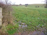
Remains today
The remains of the village can be found at the head of a small valleyValley
In geology, a valley or dale is a depression with predominant extent in one direction. A very deep river valley may be called a canyon or gorge.The terms U-shaped and V-shaped are descriptive terms of geography to characterize the form of valleys...
where there is a spring. The village stood on the west bank of the water course. There is a series of depressions and platforms which were probably the sites of dwellings. Below the stream at the southern end of the site there are several ditched enclosures along which the stream flows today.
Surrounding settlements
In close vicinity to the lost village there are three other villages and one small hamlet called Little Braunston. The villages are called BraunstonBraunston
Braunston is a village and civil parish in the county of Northamptonshire, England. It has a population of 1,675 . Braunston is situated just off the A45 main road and lies between the towns of Rugby and Daventry....
, Braunstonbury
Braunstonbury
The lost village of Braunstonbury lies in low ground south-west of the village of Braunston in the English county of Northamptonshire. Its site is on the eastern bank of the River Leam, which also marks the border between Northamptonshire and Warwickshire....
and Wolfhampcote
Wolfhampcote
Wolfhampcote is an abandoned village and civil parish in the English counties of Warwickshire and Northamptonshire, which it straddles.The old village of Wolfhampcote is located west of the A45 road near Braunston in Northamptonshire, and can be reached by a track from the main A45 road, or by a...
of which the last two are both deserted villages.