

Borden Island
Encyclopedia
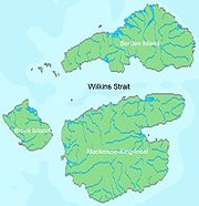
Borden Island is an uninhabited, low-lying island
in the Queen Elizabeth Islands
of northern Canada
. With an area of 2795 km² (1,079.2 sq mi) in size, it is the 172nd largest island in the world, and Canada's 30th largest island. It lies north of Mackenzie King Island
and is similarly split between Northwest Territories
(larger portion) and Nunavut
, with the border running along the 110th meridian west
.
It is named for former Prime Minister Robert Borden
.
The first known sighting of the island was by Vilhjalmur Stefansson
in 1916, it was originally described as a single landmass. However, in 1947, during an aerial survey by the Royal Canadian Air Force
the island was found to be two islands divided by Wilkins Strait
.
Island
An island or isle is any piece of sub-continental land that is surrounded by water. Very small islands such as emergent land features on atolls can be called islets, cays or keys. An island in a river or lake may be called an eyot , or holm...
in the Queen Elizabeth Islands
Queen Elizabeth Islands
The Queen Elizabeth Islands are the northernmost cluster of islands in the Canadian Arctic Archipelago, split between Nunavut and Northwest Territories in Northern Canada.-Geography:...
of northern Canada
Canada
Canada is a North American country consisting of ten provinces and three territories. Located in the northern part of the continent, it extends from the Atlantic Ocean in the east to the Pacific Ocean in the west, and northward into the Arctic Ocean...
. With an area of 2795 km² (1,079.2 sq mi) in size, it is the 172nd largest island in the world, and Canada's 30th largest island. It lies north of Mackenzie King Island
Mackenzie King Island
Mackenzie King Island is one of the Queen Elizabeth Islands in northern Canada. It lies north of Melville Island and south of Borden Island, and like them is divided. Most of the island is in Northwest Territories, while its easternmost portion lies in Nunavut...
and is similarly split between Northwest Territories
Northwest Territories
The Northwest Territories is a federal territory of Canada.Located in northern Canada, the territory borders Canada's two other territories, Yukon to the west and Nunavut to the east, and three provinces: British Columbia to the southwest, and Alberta and Saskatchewan to the south...
(larger portion) and Nunavut
Nunavut
Nunavut is the largest and newest federal territory of Canada; it was separated officially from the Northwest Territories on April 1, 1999, via the Nunavut Act and the Nunavut Land Claims Agreement Act, though the actual boundaries had been established in 1993...
, with the border running along the 110th meridian west
110th meridian west
The meridian 110° west of Greenwich is a line of longitude that extends from the North Pole across the Arctic Ocean, North America, the Pacific Ocean, the Southern Ocean, and Antarctica to the South Pole....
.
It is named for former Prime Minister Robert Borden
Robert Borden
Sir Robert Laird Borden, PC, GCMG, KC was a Canadian lawyer and politician. He served as the eighth Prime Minister of Canada from October 10, 1911 to July 10, 1920, and was the third Nova Scotian to hold this office...
.
The first known sighting of the island was by Vilhjalmur Stefansson
Vilhjalmur Stefansson
Vilhjalmur Stefansson was a Canadian Arctic explorer and ethnologist.-Early life:Stefansson, born William Stephenson, was born at Gimli, Manitoba, Canada, in 1879. His parents had emigrated from Iceland to Manitoba two years earlier...
in 1916, it was originally described as a single landmass. However, in 1947, during an aerial survey by the Royal Canadian Air Force
Royal Canadian Air Force
The history of the Royal Canadian Air Force begins in 1920, when the air force was created as the Canadian Air Force . In 1924 the CAF was renamed the Royal Canadian Air Force and granted royal sanction by King George V. The RCAF existed as an independent service until 1968...
the island was found to be two islands divided by Wilkins Strait
Wilkins Strait (Canada)
Wilkins Strait is a natural waterway through the central Canadian Arctic Archipelago. It is mostly in the Northwest Territories, although its eastern extremity is in Nunavut. It separates Borden Island from Brock Island and Mackenzie King Island ....
.
Further reading