
Bonython, Australian Capital Territory
Encyclopedia
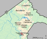
Bonython is a suburb of Tuggeranong, a township in southern Canberra
, capital city of Australia
.
, the owner of The Advertiser (Adelaide) who promoted Federation
, and was a member of the first Australian parliament. Original concept plans for Tuggeranong indicate that the suburb was initially to be known as "Stranger". The name "Bonython" was declared when it was gazetted as a suburb of Canberra on 17 October 1986. Streets are named after South Australians, especially journalists.
Prior to 1986, the land upon which Bonython now sits was grazing land, mainly grassland with scattered eucalypt trees. By 1989 construction of houses and the Stranger Pond
water quality control pond began and Canberra’s newest suburb was born.
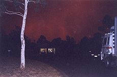
On 18 January 2003 the disastrous Canberra bushfire reached Bonython late in the afternoon. By that time, the winds had eased and the fire intensity was such that, where the fire reached housing on the western and southern fringes, residents were able to keep the fire at bay at their fencelines.
Bonython adjoins the suburbs of Greenway to the north, Isabella Plains to the east and Gordon to the south. On the western side of Bonython is a nature reserve bordering the Murrumbidgee River
.

, Medicare Australia
and the Department of Families, Community Services and Indigenous Affairs (Australia)
as well as numerous retail outlets in and around the Tuggeranong Hyperdome
shopping mall. Many Bonython residents can walk to work – a rare luxury in a city designed in the 20th century primarily for car transportation.
in 1992. Located in Hurtle Avenue and adjoining the Bonython shops, it is a public school operated by the ACT Government (Department of Education and Training) and includes Bonython Pre-school. The school’s catchment area is primarily the suburb of Bonython itself – 68%.of students live within the school’s catchment area, while 32% of students are ‘out-of-area’. According to the Department’s publication Towards 2020 Renewing Our Schools For the Future, Bonython Primary School had 365 children enrolled in 2006 (capacity 400), sufficient numbers to ensure the school’s survival to 2010 and beyond. Bonython Pre-school had 65 children enrolled in 2006. The school was designed for conversion into unit-style residential accommodation when, eventually, school enrolments are insufficient to sustain its continued operation.
On Barr-Smith Avenue, close to the Bonython Primary School, is the Stepping Stones Child Care Centre. This Centre provides childcare to working parents.
Between Bonython Primary School and Drakeford Drive is the Bonython Neighbourhood oval. This is a community oval, used by school students on school days and by various Tuggeranong sporting clubs on weekends. The oval has suffered during the drought and is currently not being maintained due to water restrictions. Consequently, the oval is unsuitable for community use and will require restoration if water restrictions are eased in future.
An additional 800 residences were constructed between 2007 and 2010, comprising a mixture of apartments, units, courtyard homes and standalone residences.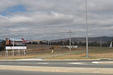 Stranger Pond has been lengthened so that the eastern end now continues almost to Barr Smith Avenue.
Bonython is now a well established inner suburb of Tuggeranong, with mature trees. Improvements continue with bus shelters being erected on various main roads, and improved traffic safety features. However, the western side of Barr Smith Avenue continues to suffer from inadequate footpath connections to bus stops and bus shelters.
The opening of the Caroline Chisholm Centre http://www.fraserscommercialtrust.com/carolinechisholmcentre in March 2008 at Greenway has heightened the suburb's appeal as a residential location.
 ACTION
Bus Services for Bonython are:
form the base of Bonython and Mount Stranger.
Canberra
Canberra is the capital city of Australia. With a population of over 345,000, it is Australia's largest inland city and the eighth-largest city overall. The city is located at the northern end of the Australian Capital Territory , south-west of Sydney, and north-east of Melbourne...
, capital city of Australia
Australia
Australia , officially the Commonwealth of Australia, is a country in the Southern Hemisphere comprising the mainland of the Australian continent, the island of Tasmania, and numerous smaller islands in the Indian and Pacific Oceans. It is the world's sixth-largest country by total area...
.
History
The suburb is named after Sir John Langdon BonythonJohn Langdon Bonython
-Early life:Bonython was born in London in 1848, the second son of George Langdon Bonython and Annie MacBain. The family migrated to South Australia in July 1854. There, Bonython was educated at the Brougham School in North Adelaide...
, the owner of The Advertiser (Adelaide) who promoted Federation
Federation
A federation , also known as a federal state, is a type of sovereign state characterized by a union of partially self-governing states or regions united by a central government...
, and was a member of the first Australian parliament. Original concept plans for Tuggeranong indicate that the suburb was initially to be known as "Stranger". The name "Bonython" was declared when it was gazetted as a suburb of Canberra on 17 October 1986. Streets are named after South Australians, especially journalists.
Prior to 1986, the land upon which Bonython now sits was grazing land, mainly grassland with scattered eucalypt trees. By 1989 construction of houses and the Stranger Pond
Stranger Pond
Stranger Pond is a water quality control pond in northwest Bonython, a suburb of Tuggeranong, the southern district of Canberra. Stranger Pond was formed by a man-made dam across a natural drainage channel.-Geography:...
water quality control pond began and Canberra’s newest suburb was born.
On 18 January 2003 the disastrous Canberra bushfire reached Bonython late in the afternoon. By that time, the winds had eased and the fire intensity was such that, where the fire reached housing on the western and southern fringes, residents were able to keep the fire at bay at their fencelines.
Geography
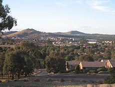
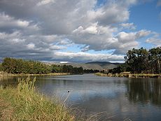
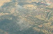
Bonython is an elongate suburb, straddling the eastern and northern sides of Mount Stranger, a low hillside (altitude 660 metres asl) that rises about 100 metres above the Tuggeranong valley floor. Stranger Pond sits at the northern end of the suburb, formed by a manmade dam across a natural drainage channel. The Pond surroundings were landscaped early during the suburb’s construction and have now become a focus for a variety of native wildlife, including black swans, pelicans and kangaroos. The Pond surroundings provide popular walking trails through bushland for local residents, and some trails connect with the Canberra equestrian trail and the Kambah Pool to Pine Island Walking Track.Bonython adjoins the suburbs of Greenway to the north, Isabella Plains to the east and Gordon to the south. On the western side of Bonython is a nature reserve bordering the Murrumbidgee River
Murrumbidgee River
The Murrumbidgee River is a major river in the state of New South Wales, Australia, and the Australian Capital Territory . A major tributary of the Murray River, the Murrumbidgee flows in a west-northwesterly direction from the foot of Peppercorn Hill in the Fiery Range of the Snowy Mountains,...
.
Demographics
Like many Canberra suburbs, Bonython accommodates a dormitory community, with the working population commuting to places of employment in nearby Tuggeranong or elsewhere within Canberra or Queanbeyan (a nearby city in New South Wales). The suburb is conveniently close to a number of major employers in the nearby Tuggeranong Town Centre (distance 1-2 kilometres). Employment in the Town Centre is provided by a number of Commonwealth government agencies, such as CentrelinkCentrelink
Centrelink is the trading name of the Commonwealth Service Delivery Agency , a statutory authority responsible for delivering human services on behalf of agencies of the Commonwealth Government of Australia. The majority of Centrelink's services are the disbursement of social security payments...
, Medicare Australia
Medicare Australia
Medicare Australia is an agency of the Australian Government that administers health-related programs including Medicare, the Pharmaceutical Benefits Scheme , and others. It is a prescribed agency under the Financial Management and Accountability Act 1997 and a statutory agency within the...
and the Department of Families, Community Services and Indigenous Affairs (Australia)
Department of Families, Community Services and Indigenous Affairs (Australia)
The Department of Families, Housing, Community Services and Indigenous Affairs is an Australian Government department. Its main office is located in Southern Canberra in the suburb of Greenway. Its role is to develop social policies and support affected Australian society and the living standards...
as well as numerous retail outlets in and around the Tuggeranong Hyperdome
Tuggeranong Hyperdome
The Tuggeranong Hyperdome is a two-storey regional shopping centre located in Greenway, Australian Capital Territory, servicing the district of Tuggeranong.-Ownership:...
shopping mall. Many Bonython residents can walk to work – a rare luxury in a city designed in the 20th century primarily for car transportation.
Amenities
Being so close to the Tuggeranong Town Centre, Bonython contains very few shops of its own – a general store and a couple of niche shops. In the centre of the suburb is the Bonython Primary School, opened by Queen Elizabeth IIElizabeth II of the United Kingdom
Elizabeth II is the constitutional monarch of 16 sovereign states known as the Commonwealth realms: the United Kingdom, Canada, Australia, New Zealand, Jamaica, Barbados, the Bahamas, Grenada, Papua New Guinea, the Solomon Islands, Tuvalu, Saint Lucia, Saint Vincent and the Grenadines, Belize,...
in 1992. Located in Hurtle Avenue and adjoining the Bonython shops, it is a public school operated by the ACT Government (Department of Education and Training) and includes Bonython Pre-school. The school’s catchment area is primarily the suburb of Bonython itself – 68%.of students live within the school’s catchment area, while 32% of students are ‘out-of-area’. According to the Department’s publication Towards 2020 Renewing Our Schools For the Future, Bonython Primary School had 365 children enrolled in 2006 (capacity 400), sufficient numbers to ensure the school’s survival to 2010 and beyond. Bonython Pre-school had 65 children enrolled in 2006. The school was designed for conversion into unit-style residential accommodation when, eventually, school enrolments are insufficient to sustain its continued operation.
On Barr-Smith Avenue, close to the Bonython Primary School, is the Stepping Stones Child Care Centre. This Centre provides childcare to working parents.
Between Bonython Primary School and Drakeford Drive is the Bonython Neighbourhood oval. This is a community oval, used by school students on school days and by various Tuggeranong sporting clubs on weekends. The oval has suffered during the drought and is currently not being maintained due to water restrictions. Consequently, the oval is unsuitable for community use and will require restoration if water restrictions are eased in future.
Changes
In 2007, the final release of residential land in Bonython began with the development of West Bonython, between the northern shore of Stranger Pond and Athllon Drive. The development was undertaken by the ACT Land Development Agency - this estate was initially promoted as 'Brindabellas', but that label was quietly dropped and the area is now simply part of Bonython. By June 2010, only one block of land had yet to be built on - this was one of the first blocks sold. Construction started on the "Montana" townhouse complex in December 2010.An additional 800 residences were constructed between 2007 and 2010, comprising a mixture of apartments, units, courtyard homes and standalone residences.
Bonython is now a well established inner suburb of Tuggeranong, with mature trees. Improvements continue with bus shelters being erected on various main roads, and improved traffic safety features. However, the western side of Barr Smith Avenue continues to suffer from inadequate footpath connections to bus stops and bus shelters.
The opening of the Caroline Chisholm Centre http://www.fraserscommercialtrust.com/carolinechisholmcentre in March 2008 at Greenway has heightened the suburb's appeal as a residential location.
Weather
Current weather conditions in Bonython are closely reflected by the Isabella Plains automatic weather station, which is only several hundred metres away from the eastern boundary of the suburb.Bus services
ACTION
ACTION is a public bus service operating in Canberra, ACT, Australia. It is operated by the ACT Department of Territory and Municipal Services...
Bus Services for Bonython are:
- 19: South to Conder/Banks, North to Tuggeranong Interchange (Monday-Friday only)
- 66: South to Tuggeranong Interchange, North to Woden Interchange via Richardson, Chisholm and Gowrie
- 319: South to Conder/Banks, North to Belconnen via Intertown (Monday-Friday only)
- 913: Weekend and Nighttime loop service to Tuggeranong Interchange
- 914: Weekend and Nighttime loop service to Tuggeranong Interchange (opposite direction to 913)
Geology
Deakin Volcanics green grey, purple and cream rhyoliteRhyolite
This page is about a volcanic rock. For the ghost town see Rhyolite, Nevada, and for the satellite system, see Rhyolite/Aquacade.Rhyolite is an igneous, volcanic rock, of felsic composition . It may have any texture from glassy to aphanitic to porphyritic...
form the base of Bonython and Mount Stranger.