

Bonito de Minas
Encyclopedia
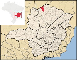
Minas Gerais
Minas Gerais is one of the 26 states of Brazil, of which it is the second most populous, the third richest, and the fourth largest in area. Minas Gerais is the Brazilian state with the largest number of Presidents of Brazil, the current one, Dilma Rousseff, being one of them. The capital is the...
. As of 2007 the population was 8,787 in a total area of 3,901 km². The elevation is 629 meters. It became a municipality in 1997. The postal code (CEP) is 39490-000.
Bonito de Minas is part of the statistical microregion of Januária
Januária
Januária, known as "The Queen of the Beautiful Waters" is a city and municipality in northern Minas Gerais state, Brazil. It is located on the left bank of the São Francisco River...
. It is surrounded by the following municipalities: Januária
Januária
Januária, known as "The Queen of the Beautiful Waters" is a city and municipality in northern Minas Gerais state, Brazil. It is located on the left bank of the São Francisco River...
, Montalvânia
Montalvânia
Montalvânia is a municipality in the northernmost point of the state of Minas Gerais in Brazil. As of 2008 the population was 16,265 in an area of 1,484.388 km². The elevation of the municipal seat is 510 meters, the postal code is 39495-000 and it is located in the microregion of Januária-...
, Cônego Marinho
Cônego Marinho
Cônego Marinho is a municipality in the north of the state of Minas Gerais in Brazil. As of 2007 the population was 6,279 in an area of 1,618 km².*The elevation of the municipal seat is 637 meters.*It became a municipality in 1997....
, and the state of Bahia
Bahia
Bahia is one of the 26 states of Brazil, and is located in the northeastern part of the country on the Atlantic coast. It is the fourth most populous Brazilian state after São Paulo, Minas Gerais and Rio de Janeiro, and the fifth-largest in size...
. It is connected by poor roads to the regional center of Januária to the south. The distance is 48 kilometers. The Serra dos Tropeiros and the boundary with the state of Bahia are to the north.
This is one of the poorest municipalities in the state and in the country. The main economic activities are cattle raising and farming with modest production of rice, beans, corn, and lemons. In 2006 there were 695 rural producers with a total area of 63,936 hectares. Cropland made up 4,800 hectares. There were only 36 tractors. In the urban area there were no financial institutions as of 2006. There were 13 automobiles, giving a ratio of about one automobile for every 676 inhabitants, one of the worst in the country. Health care was provided by 1 public health clinic. There were no hospitals.
Municipal Human Development Index
Human Development Index
The Human Development Index is a composite statistic used to rank countries by level of "human development" and separate "very high human development", "high human development", "medium human development", and "low human development" countries...
- MHDI: .580 (2000)
- State ranking: 849 out of 853 municipalities as of 2000
- National ranking: 4,979 out of 5,138 municipalities as of 2000
- Life expectancy: 64
- Literacy rate: 62
- Combined primary, secondary and tertiary gross enrolment ratio: .744
- Per capita income (monthly): R$49.12 (For the complete list see Frigoletto)