
Bobbin Head, New South Wales
Encyclopedia
Sydney
Sydney is the most populous city in Australia and the state capital of New South Wales. Sydney is located on Australia's south-east coast of the Tasman Sea. As of June 2010, the greater metropolitan area had an approximate population of 4.6 million people...
, in the state of New South Wales
New South Wales
New South Wales is a state of :Australia, located in the east of the country. It is bordered by Queensland, Victoria and South Australia to the north, south and west respectively. To the east, the state is bordered by the Tasman Sea, which forms part of the Pacific Ocean. New South Wales...
, Australia
Australia
Australia , officially the Commonwealth of Australia, is a country in the Southern Hemisphere comprising the mainland of the Australian continent, the island of Tasmania, and numerous smaller islands in the Indian and Pacific Oceans. It is the world's sixth-largest country by total area...
.
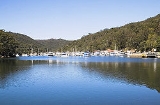
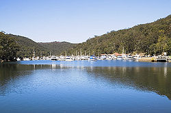
Bobbin Head is a scenic area that is a "near-urban" part of Ku-ring-gai Chase National Park
Ku-ring-gai Chase National Park
Ku-ring-gai Chase is a national park in New South Wales, Australia, 25 km north of Sydney located largely within the Ku-ring-gai, Hornsby, Warringah and Pittwater municipal areas. Ku-ring-gai Chase is also officially classed as a suburb by the Geographical Names Board of New South Wales...
. Bobbin Head is easily reached by taking Bobbin Head Road through North Turramurra, New South Wales
North Turramurra, New South Wales
-Transport:The nearest train station is Turramurra railway station. Buses to North Turramurra are serviced by Shorelink at Turramurra train station. Shorelink bus route 577 runs through North Turramurra...
or Kuringai Chase Road, Mount Colah near Hornsby, New South Wales
Hornsby, New South Wales
* Highest Maximum Temperature: 42 °C* Lowest Maximum Temperature: 4.9 °C* Warmest Month: January* Coolest Month: July* Highest Precipitation: February* Lowest Precipitation: July-Notable residents:...
.
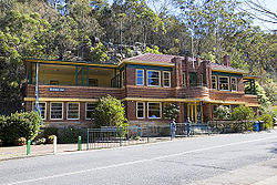
Facilities at Bobbin Head include an award winning marina, picnic areas with gas barbecues (coin-operated), a licensed restaurant and kiosk at the marina, small boat hire at the marina, and a lunch-time restaurant in what used to be the Bobbin Head Inn, which also contains a National Parks information centre. The area also contains many fire trails and a mangrove boardwalk. Aboriginal engravings can be observed along some of the bushwalk trails. There is also a discovery trail along the waterfront inside the marina that chronicles the history of the area.
See also
- Dangar IslandDangar IslandDangar Island is a small forested island in the Hawkesbury River, just north of Sydney, New South Wales, Australia. It has a permanent population of about 250, which swells dramatically during holiday seasons. The island is serviced regularly by the Dangar Island Ferry service that departs from...
- Hawkesbury River Railway BridgeHawkesbury River Railway BridgeThe Hawkesbury River Railway Bridge spans the Hawkesbury River just north of the town of Brooklyn on the northern outskirts of Sydney, Australia...
- Hawkesbury RiverHawkesbury RiverThe Hawkesbury River, also known as Deerubbun, is one of the major rivers of the coastal region of New South Wales, Australia. The Hawkesbury River and its tributaries virtually encircle the metropolitan region of Sydney.-Geography:-Course:...
- Scotland Island
- Church Point FerryChurch Point FerryChurch Point Ferry provides ferry services from Church Point, situated on Pittwater in the northern suburbs of Sydney, New South Wales, Australia. The ferry provides an hourly service to Scotland Island and Ku-ring-gai Chase, where it stops at Halls Wharf, Lovett Bay and Elvina Bay.-External links:*...
- Pittwater CouncilPittwater CouncilPittwater Council is a Local Government Area on the Northern Beaches of Sydney, in the state of New South Wales, Australia. The suburbs which comprise the Pittwater LGA were detached from the Warringah local government area in 1993...