

Blockley Township, Pennsylvania
Encyclopedia
Township (Pennsylvania)
A township in the Commonwealth of Pennsylvania, a state of the United States of America, is one of four types of municipalities in the state . Townships were established based on convenient geographical boundaries and vary in size from six to forty square miles...
that was located in Philadelphia County, Pennsylvania
Philadelphia County, Pennsylvania
-History:Tribes of Lenape were the first known occupants in the area which became Philadelphia County. The first European settlers were Swedes and Finns who arrived in 1638. The Netherlands seized the area in 1655, but permanently lost control to England in 1674...
. The township ceased to exist and was incorporated into the City of Philadelphia
Philadelphia, Pennsylvania
Philadelphia is the largest city in the Commonwealth of Pennsylvania and the county seat of Philadelphia County, with which it is coterminous. The city is located in the Northeastern United States along the Delaware and Schuylkill rivers. It is the fifth-most-populous city in the United States,...
following the passage of the Act of Consolidation, 1854
Act of Consolidation, 1854
The Act of Consolidation, more formally known as the act of February 2, 1854 , was enacted by General Assembly of the Commonwealth of Pennsylvania and approved February 2, 1854 by Governor William Bigler...
.
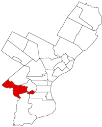
History
Blockley Township was located on the west side of the Schuylkill RiverSchuylkill River
The Schuylkill River is a river in Pennsylvania. It is a designated Pennsylvania Scenic River.The river is about long. Its watershed of about lies entirely within the state of Pennsylvania. The source of its eastern branch is in the Appalachian Mountains at Tuscarora Springs, near Tamaqua in...
, north of Kingsessing Township
Kingsessing, Philadelphia, Pennsylvania
Kingsessing is a neighborhood in the Southwest section of Philadelphia, Pennsylvania, United States, located adjacent to the neighborhoods of Cedar Park, Southwest Schuykill, and Mount Moriah, as well as Yeadon in Delaware County...
; bounded on the east by the Schuylkill; extending south from the county line, opposite to, but a little below, the mouth of the Wissahickon
Wissahickon Creek
Wissahickon Creek is a stream in southeastern Pennsylvania. Rising in Montgomery County, Pennsylvania, it runs about 23 miles passing through and dividing Northwest Philadelphia before emptying into the Schuylkill River at Philadelphia...
, down to the Nanganesy or Mill Creek, below the Woodlands; then by the same creek up to Chadd’s Ford Turnpike, known in later years as the Baltimore Pike
Baltimore Pike
thumb|[[SEPTA]]'s [[SEPTA Route 34|Route 34]] streetcar line runs through the 4500 block of Baltimore Avenue in [[West Philadelphia]]The Baltimore Pike was an auto trail in the United States, connecting Baltimore, Maryland with Philadelphia, Pennsylvania....
; along the same to Cobb’s Creek
Cobbs Creek
Cobbs Creek is an tributary of Darby Creek in Delaware County, Pennsylvania in the United States. It forms an approximate border between Montgomery County and Delaware County. After Cobbs Creek passes underneath Township Line Road , it forms the border between Philadelphia County and Delaware County...
; then by the courses of the same to the county line adjoining Lower Merion Township
Lower Merion Township, Pennsylvania
Lower Merion Township is a township in Montgomery County, Pennsylvania and part of the Pennsylvania Main Line. As of the 2010 census, the township had a total population of 57,825...
, Montgomery County
Montgomery County, Pennsylvania
Montgomery County is a county located in the U.S. state of Pennsylvania, in the United States. As of 2010, the population was 799,874, making it the third most populous county in Pennsylvania . The county seat is Norristown.The county was created on September 10, 1784, out of land originally part...
, and along the same to the Delaware River
Delaware River
The Delaware River is a major river on the Atlantic coast of the United States.A Dutch expedition led by Henry Hudson in 1609 first mapped the river. The river was christened the South River in the New Netherland colony that followed, in contrast to the North River, as the Hudson River was then...
.
It was traversed by the Darby Road [Woodland Avenue], Chadd’s Ford, or Baltimore Pike, the road to West Chester
West Chester, Pennsylvania
The Borough of West Chester is the county seat of Chester County, Pennsylvania, United States. The population was 18,461 at the 2010 census.Valley Forge, the Brandywine Battlefield, Longwood Gardens, Marsh Creek State Park, and other historical attractions are near West Chester...
, to Haverford
Haverford, Pennsylvania
Haverford is an unincorporated community located partially in Haverford Township in Delaware County, Pennsylvania, USA, but primarily in Lower Merion Township in Montgomery County, about west of Philadelphia. It is on the Main Line, which is known historically for its wealth. As of August 2009,...
and to Lancaster
Lancaster, Pennsylvania
Lancaster is a city in the south-central part of the Commonwealth of Pennsylvania. It is the county seat of Lancaster County and one of the older inland cities in the United States, . With a population of 59,322, it ranks eighth in population among Pennsylvania's cities...
. Within its boundaries were the villages of Hamilton, Mantua
Mantua, Philadelphia, Pennsylvania
Mantua is a neighborhood in the West Philadelphia section of Philadelphia, Pennsylvania. It is located north of Spring Garden Street, east of 40th Street, south of Mantua Avenue, and west of 31st Street...
, West Philadelphia, Hestonville and Haddington
Haddington, Philadelphia, Pennsylvania
Haddington is a neighborhood in the West Philadelphia section of Philadelphia, Pennsylvania. It is arguably located between 52nd Street and 63rd Street, bounded by Chestnut Street and Girard Avenue....
. The greatest length, 4 miles (6 km); the greatest breadth, 5 miles (8 km); area, 7,580 acres (31 km²).
The boundaries and area would change on February 17, 1844 when the area encompassing Mantua and Hamilton were incorporated into the Borough of West Philadelphia
West Philadelphia Borough, Pennsylvania
West Philadelphia Borough, also known as West Philadelphia District, is a defunct borough that was located west of the Schuylkill River in Blockley Township, Philadelphia County, Pennsylvania...
, almost creating two unconnected sections of the township.
The name is supposed to have been derived from Blockley
Blockley
Blockley is a village and civil parish in the Cotswold district of Gloucestershire, England, about northwest of Moreton-in-Marsh. Until 1931 Blockley was an exclave of Worcestershire....
, a parish in England
England
England is a country that is part of the United Kingdom. It shares land borders with Scotland to the north and Wales to the west; the Irish Sea is to the north west, the Celtic Sea to the south west, with the North Sea to the east and the English Channel to the south separating it from continental...
in Worcestershire
Worcestershire
Worcestershire is a non-metropolitan county, established in antiquity, located in the West Midlands region of England. For Eurostat purposes it is a NUTS 3 region and is one of three counties that comprise the "Herefordshire, Worcestershire and Warwickshire" NUTS 2 region...
. In Philadelphia, "Blockley" was synonymous with the Blockley Almshouse
Blockley Almshouse
The Blockley Almshouse, later known as Philadelphia General Hospital, was a charity hospital and poorhouse located in West Philadelphia. It originally opened in 1732/33 in a different part of the city as the Philadelphia Almshouse...
that opened here in 1832. The township also contained The Woodlands; the former estate of Andrew Hamilton
Andrew Hamilton (lawyer)
Andrew Hamilton was a Scottish lawyer in Colonial America, best known for his legal victory on behalf of printer and newspaper publisher John Peter Zenger. This 1735 decision helped to establish that truth is a defense to an accusation of libel...
converted in 1840 to the Woodlands Cemetery
The Woodlands Cemetery
The Woodlands is a National Historic Landmark District on the western banks of the Schuylkill River in Philadelphia, Pennsylvania. It includes a magnificent federal style mansion, a matching carriage house and stable, and a garden landscape that in 1840 was transformed into a Victorian rural...
.
Resources
- Chronology of the Political Subdivisions of the County of Philadelphia, 1683-1854
- Information courtesy of ushistory.org
- Incorporated District, Boroughs, and Townships in the County of Philadelphia, 1854 By Rudolph J. Walther - excerpted from the book at the ushistory.org website