
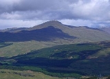
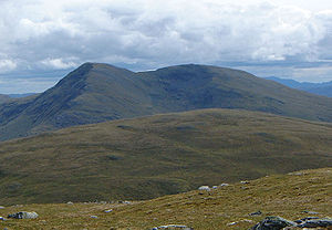
Beinn Challuim
Encyclopedia
Scotland
Scotland is a country that is part of the United Kingdom. Occupying the northern third of the island of Great Britain, it shares a border with England to the south and is bounded by the North Sea to the east, the Atlantic Ocean to the north and west, and the North Channel and Irish Sea to the...
mountain located in the very northern part of the Loch Lomond and the Trossachs National Park
Loch Lomond and the Trossachs National Park
Loch Lomond and The Trossachs National Park is a national park in Scotland centred on Loch Lomond, and includes several ranges of hills, the Trossachs being the most famous...
six kilometres east northeast of the village of Tyndrum
Tyndrum
Tyndrum is a small village in Scotland. Its Gaelic name translates as "the house on the ridge". It lies in Strathfillan, at the southern edge of Rannoch Moor.The village is notable mainly for being at an important crossroads of transport routes...
in the Stirling Council area. The mountain stands in the Forest of Mamlorn, an ancient deer
Deer
Deer are the ruminant mammals forming the family Cervidae. Species in the Cervidae family include white-tailed deer, elk, moose, red deer, reindeer, fallow deer, roe deer and chital. Male deer of all species and female reindeer grow and shed new antlers each year...
forest in Breadalbane.
Overview
With a height of 1025 metres (3363 feet) Ben Challuim qualifies as a MunroMunro
A Munro is a mountain in Scotland with a height over . They are named after Sir Hugh Munro, 4th Baronet , who produced the first list of such hills, known as Munros Tables, in 1891. A Munro top is a summit over 3,000 ft which is not regarded as a separate mountain...
and a Marilyn
Marilyn (hill)
A Marilyn is a mountain or hill in the United Kingdom, Republic of Ireland or Isle of Man with a relative height of at least 150 metres , regardless of absolute height or other merit...
. It stands at the head of Glen Lochay
Glen Lochay
Glen Lochay is in Perthshire, Scotland through which the River Lochay runs eastward towards Loch Tay, joining the River Dochart at Killin. Glen Lochay is about 20 miles long, running from a point north of Crianlarich to Loch Tay....
and is a prominent peak when seen from the head of that glen, its western slopes dominate the north eastern side of Strath Fillan. When seen from the south the summit of the mountain cannot be seen, being hidden behind the south top. The mountain name was originally written as Beinn Challuim before Ben Challum became the norm. However in recent years the Ordnance Survey
Ordnance Survey
Ordnance Survey , an executive agency and non-ministerial government department of the Government of the United Kingdom, is the national mapping agency for Great Britain, producing maps of Great Britain , and one of the world's largest producers of maps.The name reflects its creation together with...
have reverted to using the original name on their maps.
The name translates as “Malcolm’s mountain” but it is believed that the older spelling could possibly refer to Saint Columba
Columba
Saint Columba —also known as Colum Cille , Colm Cille , Calum Cille and Kolban or Kolbjørn —was a Gaelic Irish missionary monk who propagated Christianity among the Picts during the Early Medieval Period...
who is known in Scottish Gaelic as "Calum Cille". With St. Fillan
Fillan
Saint Fillan, Filan, Phillan, Fáelán or Faolan is the name of two Scottish saints, of Irish origin. The career of a historic individual lies behind at least one of these saints Saint Fillan, Filan, Phillan, Fáelán (Old Irish) or Faolan (modern Gaelic) is the name of (probably) two Scottish...
's priory lying on the south west foothills of the mountain (St Fillan brought Christianity from the monastery of St Columba on Iona into Breadalbane), the Columba connection is feasible. Some guide books give the translation as “Calum’s Peak".
Geography
Beinn Challuim is often regarded as a smooth grassy hill mainly because these are the characteristics of the southern and western slopes which are seen by many people from the A82 roadA82 road
The A82 is a trunk road in Scotland. It is the principal route from Lowland Scotland to the western Scottish Highlands, running from Glasgow to Inverness, going by Loch Lomond, Glen Coe and Fort William. It is the second longest primary A-road in Scotland after the A9, which is the other...
around Strath Fillan. However from the north it shows a more exciting form with a steep and rocky face overlooking the head of Glen Lochay. Beinn Challuim is made up of three ridges, the broad grassy south west ridge descends to Strath Fillan and is used in ascents from there. The north west ridge is steep and rocky and descends to the Bealach
Mountain pass
A mountain pass is a route through a mountain range or over a ridge. If following the lowest possible route, a pass is locally the highest point on that route...
Ghlas-Leathaid (575 metres) and then connects to the Corbett of Cam Chreag. Another ridge goes easterly, descending into Glen Lochay.
The mountain has a subsidiary summit which is listed in the Munro Tables as a “Top”, The South Top reaches a height of 998 metres and lies 600 south of the highest point. The two summit are connected by a ridge and this area can be confusing in poor visibility with the logical temptation to go north to the main summit possibly resulting in encountering steep crags. The proper route from the south top is to go initially west for a short distance across a hollow and onto the ridge which leads north to the main summit. The summit ridge has two corries
Cirque
Cirque may refer to:* Cirque, a geological formation* Makhtesh, an erosional landform found in the Negev desert of Israel and Sinai of Egypt*Cirque , an album by Biosphere* Cirque Corporation, a company that makes touchpads...
on either side, to the west is the Coire nan Each (Corrie of the Horse) and to the east is Coire Challuim (Malcolm's Corrie). Drainage from the mountain reaches both coasts of Scotland at the Firth of Tay
Firth of Tay
The Firth of Tay is a firth in Scotland between the council areas of Fife, Perth and Kinross, the City of Dundee and Angus, into which Scotland's largest river in terms of flow, the River Tay, empties....
on the east coast and the Firth of Clyde
Firth of Clyde
The Firth of Clyde forms a large area of coastal water, sheltered from the Atlantic Ocean by the Kintyre peninsula which encloses the outer firth in Argyll and Ayrshire, Scotland. The Kilbrannan Sound is a large arm of the Firth of Clyde, separating the Kintyre Peninsula from the Isle of Arran.At...
on the west coast.
Ascents and summit
The most popular route of ascent starts at Kirkton Farm in Strath Fillan (grid reference ), this gives the opportunity to visit the ruins of St. Fillans Priory at the beginning or end of the walk. The route continues north east up grassy slopes to reach the summit ridge. A more interesting ascent starts at the road end in Glen Lochay, this gives the chance to view the more noteworthy northern side of the mountain but involves a nine kilometre walk up the glen to the foot of the eastern ridge. Hamish BrownHamish Brown
Hamish Brown M.B.E. is a professional writer, lecturer and photographer specialising in mountain and outdoor topics. He is best known for his walking exploits in the Scottish Highlands, having completed multiple rounds of the Munros and being the first person to walk all the Munros in a single trip...
recommends a northern approach starting at Auch (grid reference ) “if you want to be different” but this requires good navigation and some mild scrambling up the north west ridge.
The actual summit of the mountain is named as Stob Glas (greenish-grey peak) on maps and has a large cairn
Cairn
Cairn is a term used mainly in the English-speaking world for a man-made pile of stones. It comes from the or . Cairns are found all over the world in uplands, on moorland, on mountaintops, near waterways and on sea cliffs, and also in barren desert and tundra areas...
which overlooks the sheer northern face. The view from the top gives fine views of the many peaks around the Tyndrum and Crianlarich
Crianlarich
Crianlarich is a village in the Stirling district and registration county of Perthshire, Scotland, about six miles north-east of the head of Loch Lomond...
area.