

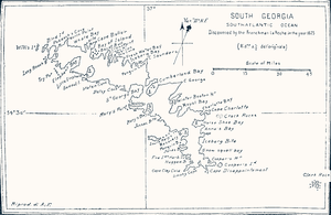
Bay of Isles
Encyclopedia
Bay
A bay is an area of water mostly surrounded by land. Bays generally have calmer waters than the surrounding sea, due to the surrounding land blocking some waves and often reducing winds. Bays also exist as an inlet in a lake or pond. A large bay may be called a gulf, a sea, a sound, or a bight...
9 miles (14.5 km) wide and receding 3 miles (5 km), lying between Cape Buller
Cape Buller
Cape Buller is a rugged headland forming the west side of the entrance to the Bay of Isles on the north coast of South Georgia. It was discovered and named in 1775 by a British expedition under James Cook....
and Cape Wilson along the north coast of South Georgia. It was discovered in 1775 by a British expedition under James Cook
James Cook
Captain James Cook, FRS, RN was a British explorer, navigator and cartographer who ultimately rose to the rank of captain in the Royal Navy...
and so named by him because numerous islands (at least twelve) lie in the bay, many of which are named after local birds. These include:
- Albatross IslandAlbatross Island (South Georgia)Albatross Island is an island southeast of Cape Buller, lying in the Bay of Isles, South Georgia. Charted in 1912–13 by Robert Cushman Murphy, American naturalist aboard the brig Daisy, who gave this name because he observed albatrosses there....
(albatrossAlbatrossAlbatrosses, of the biological family Diomedeidae, are large seabirds allied to the procellariids, storm-petrels and diving-petrels in the order Procellariiformes . They range widely in the Southern Ocean and the North Pacific...
) - Crescent IslandCrescent IslandCrescent Island is a small, roughly crescent-shaped island lying close south of Mollyhawk Island in the Bay of Isles, South Georgia. Roughly charted in 1912–13 by Robert Cushman Murphy. Surveyed and named in 1929–30 by DI personnel.- See also :...
- Invisible IslandInvisible IslandInvisible Island is a small, tussock-covered island lying close southeast of Crescent Island and Mollyhawk Island in the Bay of Isles, South Georgia. Charted in 1912-13 by Robert Cushman Murphy, American naturalist aboard the brig Daisy. Probably named by DI personnel who surveyed the Bay of Isles...
- Mollymawk IslandMollymawk IslandMollymawk Island is a small, tussock-covered island lying between Seaward Rock and Crescent Island in the north part of the Bay of Isles, South Georgia. It was charted in 1912-13 by Robert Cushman Murphy, American naturalist aboard the brig Daisy...
(mollymawkMollymawkThe mollymawks are a group of medium sized albatrosses that form the genus Thalassarche. The name has sometimes been used for the genus Phoebetria as well, but these are correctly called sooty albatrosses. They are restricted to the Southern Hemisphere, where they are the most common of the...
) - Skua IslandSkua IslandSkua Island is an island immediately northeast of Prion Island in the entrance to the Bay of Isles, South Georgia. Charted in 1912-13 by Robert Cushman Murphy, American naturalist aboard the brig Daisy. Surveyed in 1929-30 by DI personnel and named in association with Albatross Island, Prion...
(skuaSkuaThe skuas are a group of seabirds with about seven species forming the family Stercorariidae and the genus Stercorarius. The three smaller skuas are called jaegers in North America....
) - Petrel IslandPetrel Island (South Georgia)Petrel Island is an island 0.75 miles southwest of Prion Island, lying in the Bay of Isles, South Georgia. First charted in 1912-13 by Robert Cushman Murphy, American naturalist aboard the brig Daisy. Recharted in 1929-30 by DI personnel, who so named it because of its association with Prion...
(petrelPetrelPetrels are tube-nosed seabirds in the bird order Procellariiformes. The common name does not indicate relationship beyond that point, as "petrels" occur in three of the four families within that group...
) - Prion IslandPrion IslandPrion Island is an island 1.5 miles north-northeast of Luck Point, lying in the Bay of Isles, South Georgia. Charted in 1912-13 by Robert Cushman Murphy, American naturalist aboard the brig Daisy, and so named because he observed petrels of the genus Prion on the island.The area including the Bay...
(prionPrion (bird)The Prions are small petrels in the genera Pachyptila and Halobaena. They form one of the four groups within the Procellariidae , along with the gadfly petrels, shearwaters and fulmarine petrels....
) - Tern IslandTern Island, South GeorgiaTern Island is a small, tussock-covered island lying 1 mile south of Albatross Island and 0. 6 miles east of Dot Island in the south part of the Bay of Isles, South Georgia. First charted in 1912-13 by Robert Cushman Murphy, American naturalist aboard the brig Daisy...
(ternTernTerns are seabirds in the family Sternidae, previously considered a subfamily of the gull family Laridae . They form a lineage with the gulls and skimmers which in turn is related to skuas and auks...
)
The area, along with Grytviken
Grytviken
Grytviken is the principal settlement in the British territory of South Georgia in the South Atlantic. It was so named in 1902 by the Swedish surveyor Johan Gunnar Andersson who found old English try pots used to render seal oil at the site. It is the best harbour on the island, consisting of a...
is one of two ASTIs on the island. Of South Georgia's 31 breeding bird species, 17 are found here.
Rosita Harbour
Rosita Harbour
Rosita Harbor is a small bay lying north of Camp Bay in the west side of the Bay of Isles, South Georgia. The names Rosita Harbour and Allardyce Harbour were given for this bay in the period 1905-12, and both have since appeared on maps for this feature...
is on the west coast of the bay.