
Bay Trail
Encyclopedia
This article is about the trail in Melbourne. For the trail in San Francisco, see San Francisco Bay Trail
.
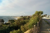
The Bay Trail is a shared use path for cyclists
and pedestrian
s which follows the coastline of Port Phillip Bay through the south-eastern suburbs of Melbourne
, Victoria
, Australia
.
The trail begins at Austin Road, Seaford
near the Edithvale-Seaford Wetlands
viewing platform and travels north. The trail ends just north of the West Gate Bridge
in Port Melbourne
. On weekends, a punt
ferries pedestrians and bicycles across the Yarra River
to Spotswood
in the city's west.
North of Elwood
the path occasionally splits in two; providing separate facilities for pedestrians and cyclists. These areas are also popular with inline skaters
.
is via the Sandridge Trail
. In the south, at Patterson River, the trail meets the Dandenong Creek Trail
, which in turn connects to the EastLink Trail
. The most southerly point is in Seaford
at the southern end of the Seaford Swamp near Austin Rd.
A path runs along Elwood Canal / Elster Creek, ending near Gardenvale Station
North end at 37.829302°S 144.900715°E.
South end at 38.105002°S 145.135552°E.
San Francisco Bay Trail
The San Francisco Bay Trail is a bicycle and pedestrian trail that will eventually allow continuous travel around the shoreline of San Francisco Bay. As of 2011, approximately 310 miles of trail have been completed...
.
The Bay Trail is a shared use path for cyclists
Cycling
Cycling, also called bicycling or biking, is the use of bicycles for transport, recreation, or for sport. Persons engaged in cycling are cyclists or bicyclists...
and pedestrian
Pedestrian
A pedestrian is a person traveling on foot, whether walking or running. In some communities, those traveling using roller skates or skateboards are also considered to be pedestrians. In modern times, the term mostly refers to someone walking on a road or footpath, but this was not the case...
s which follows the coastline of Port Phillip Bay through the south-eastern suburbs of Melbourne
Melbourne
Melbourne is the capital and most populous city in the state of Victoria, and the second most populous city in Australia. The Melbourne City Centre is the hub of the greater metropolitan area and the Census statistical division—of which "Melbourne" is the common name. As of June 2009, the greater...
, Victoria
Victoria (Australia)
Victoria is the second most populous state in Australia. Geographically the smallest mainland state, Victoria is bordered by New South Wales, South Australia, and Tasmania on Boundary Islet to the north, west and south respectively....
, Australia
Australia
Australia , officially the Commonwealth of Australia, is a country in the Southern Hemisphere comprising the mainland of the Australian continent, the island of Tasmania, and numerous smaller islands in the Indian and Pacific Oceans. It is the world's sixth-largest country by total area...
.
The trail begins at Austin Road, Seaford
Seaford, Victoria
Seaford is a suburb in Melbourne, Victoria, Australia, 36 km south-east from Melbourne's central business district. Its Local Government Area is the City of Frankston...
near the Edithvale-Seaford Wetlands
Edithvale-Seaford Wetlands
The Edithvale-Seaford Wetlands are a group of two principally freshwater swamps, totalling , lying in the suburbs of Aspendale, Edithvale, and Seaford in south-eastern Melbourne, Victoria, Australia. Together they form the Edithvale-Seaford Wetlands Ramsar Site...
viewing platform and travels north. The trail ends just north of the West Gate Bridge
West Gate Bridge
The West Gate Bridge is a steel box girder cable-stayed bridge in Melbourne, Victoria, Australia. It spans the Yarra River, just north of its mouth into Port Phillip, and is a vital link between the inner city and Melbourne's western suburbs with the industrial suburbs in the west and with the city...
in Port Melbourne
Port Melbourne, Victoria
Port Melbourne is a suburb of Melbourne, Victoria, Australia, 5 km southwest of Melbourne's central business district. Its Local Government areas are the cities of Port Phillip and Melbourne. At the 2006 Census, Port Melbourne had a population of 13,293....
. On weekends, a punt
Cable ferry
A cable ferry is guided and in many cases propelled across a river or other larger body of water by cables connected to both shores. They are also called chain ferries, floating bridges, or punts....
ferries pedestrians and bicycles across the Yarra River
Yarra River
The Yarra River, originally Birrarung, is a river in east-central Victoria, Australia. The lower stretches of the river is where the city of Melbourne was established in 1835 and today Greater Melbourne dominates and influences the landscape of its lower reaches...
to Spotswood
Spotswood, Victoria
Spotswood is a suburb in Melbourne, Victoria, Australia, 7 km south-west from Melbourne's central business district. Its Local Government Area is the City of Hobsons Bay...
in the city's west.
North of Elwood
Elwood, Victoria
Elwood is a suburb in Melbourne, Victoria, Australia, 8 km south from Melbourne's central business district. Its Local Government Area is the City of Port Phillip...
the path occasionally splits in two; providing separate facilities for pedestrians and cyclists. These areas are also popular with inline skaters
Inline skating
Inline skating is a recreational sport practiced widely internationally. Inline skates typically have 2 to 5 polyurethane wheels, arranged in a single line. The in-line design allows for greater speed than roller skates and better maneuverability...
.
Following the path
- In the south, the trail begins a short distance from Seaford railway stationSeaford railway station, MelbourneSeaford is a railway station in Melbourne, Victoria, Australia, located in the suburb of Seaford, on the Frankston railway line. Seaford is unmanned and is in Metcard Zone 2.-Facilities:...
.
- The trail appears to end at Armstrongs Road, Seaford, however it continues at the end of Wilson Grove.
- North of the Eel Race Drain footbridge, the trail splits into two. Take the trail on the left to ride north-east through Roy Dore Reserve in CarrumCarrum, VictoriaCarrum is a suburb in Melbourne, Victoria, Australia, south-east from Melbourne's central business district. Its Local Government Area is the City of Kingston...
. The trail on the right heads east towards Patterson LakesPatterson Lakes, VictoriaPatterson Lakes is a suburb in outer south-east Melbourne, Victoria, Australia, and is located 32 km south-east of Melbourne's central business district. Its Local Government Area is the City of Kingston. In the 2006 Census Patterson Lakes had a population of 7,235 people.Patterson Lakes consists...
shopping centre, and eventually connects with the Dandenong Creek TrailDandenong Creek TrailThe Dandenong Creek Trail is a shared use path for cyclists and pedestrians, which follows Dandenong Creek through the outer eastern and south-eastern suburbs of Melbourne, Victoria, Australia.-Following the Path:...
.
- A set of pedestrian lights have been installed on busy McLeod Road, Carrum, opposite McDougall Reserve. On the northern side of the crossing is Launching Way, where the trail continues towards the Patterson RiverPatterson RiverThe Patterson River is a partly man-made waterway located approximately 35km south-east of Melbourne, Australia in Patterson Lakes, Carrum and Bonbeach....
boat launching ramps, where the trail then heads south-west for a short distance (0.5 km) towards the bay.
- A caged cycling/pedestrian bridge crosses Patterson River parallel to the railway bridge and Nepean HighwayNepean HighwayNepean Highway runs south from the centre of Melbourne in Victoria, Australia to Portsea, along the eastern shore of Port Phillip. It is the primary road route to central Melbourne from Melbourne's southern suburbs.- History :...
. Once on the north bank, the trail heads north-east, inland, for approximately 2 km, then down an embankment, now heading north-west.
- The trail continues to head north-east, going under the railway bridge at MordiallocMordialloc, VictoriaMordialloc is a suburb in Melbourne, Victoria, Australia, 24 km south-east from Melbourne's central business district. Its Local Government Area is the City of Kingston...
, with an underpass at Nepean Highway shortly after crossing over the Mordialloc Creek bridge.
- From Mordialloc onward, the trail now runs along the coast between the sand and Beach Road. A short gravel section of the trail between Mordialloc and Parkdale is narrow and runs between the sand dunes. It connects with a concrete section that runs beneath the cliffs, ending at McBean Ramp in BeaumarisBeaumaris, VictoriaBeaumaris is a suburb in Melbourne, Victoria, Australia, 20 km south-east from Melbourne's central business district. Its Local Government Area is the City of Bayside. At the 2006 Census, Beaumaris had a population of 12,441....
.
- From McBean Ramp, the trail heads south-west. A 750 metre section of the trail is missing between McBean Ramp and the Beaumaris Motor Yacht Squadron, near Cromer Road. Cyclists in either direction should probably use Beach Road. Pedestrians may use the path that follows the cliff's edge, parallel to Beach Road.
- From Cromer Road onward, the trail is concrete, with a dashed line in the centre, heading south-west for 1 km, reaching Table Rock Point in Beaumaris.
- From Table Rock Point onward, navigation is fairly self-explanatory. The trail heads north-west towards Port Melbourne, passing through the suburbs of Black RockBlack Rock, VictoriaBlack Rock is a suburb in Melbourne, Victoria, Australia, 18 km south-east from Melbourne's central business district. Its Local Government Area is the City of Bayside. At the 2006 Census, Black Rock had a population of 5796.-History:...
, SandringhamSandringham, VictoriaSandringham is a suburb in Melbourne, Victoria, Australia, 16 km south-east from Melbourne's central business district. Its Local Government Area is the City of Bayside. At the 2006 Census, Sandringham had a population of 8693.-History:...
, HamptonHampton, VictoriaHampton is a suburb in Melbourne, Victoria, Australia, 14 km south east from Melbourne's central business district. Its Local Government Area is the City of Bayside. At the 2006 Census, Hampton had a population of 11,825.Hampton is located in a wealthy bayside area of Melbourne, wedged between the...
, BrightonBrighton, VictoriaBrighton is a suburb of Melbourne, Victoria, Australia, 11 km south-east from Melbourne's central business district. Its Local Government Area is the City of Bayside. At the 2006 Census, Brighton had a population of 20,651...
, ElwoodElwood, VictoriaElwood is a suburb in Melbourne, Victoria, Australia, 8 km south from Melbourne's central business district. Its Local Government Area is the City of Port Phillip...
, St KildaSt Kilda, VictoriaSt Kilda is an inner city suburb of Melbourne, Victoria, Australia, 6 km south from Melbourne's central business district. Its Local Government Area is the City of Port Phillip...
, Middle ParkMiddle Park, VictoriaMiddle Park is a suburb in Melbourne, Victoria, Australia, 5 km south from Melbourne's central business district. Its Local Government Area is the City of Port Phillip. At the 2006 Census, Middle Park had a population of 4012...
, and Albert ParkAlbert Park, VictoriaAlbert Park is an inner city suburb of Melbourne, Victoria, Australia, 3 km south from Melbourne's central business district. Its Local Government Area is the City of Port Phillip. At the 2006 Census, Albert Park had a population of 5827....
.
Landmarks
- Port Phillip Bay
- Patterson RiverPatterson RiverThe Patterson River is a partly man-made waterway located approximately 35km south-east of Melbourne, Australia in Patterson Lakes, Carrum and Bonbeach....
- Edithvale-Seaford Wetlands
- Mordialloc Creek
- Ricketts Point Tea House
- Half Moon BayHalf Moon Bay, VictoriaHalf Moon Bay is a bay and neighbourhood on Port Phillip, south east of Melbourne. Located in the suburb of Black Rock, it is home to the Black Rock Yacht Club. This bay also gets a mention in the Cat Empire song, "The Wine Song". Half Moon Bay is also home to HMVS Cerberus, the last surviving...
- Wreck of HMAS Cerberus
- Sandringham Harbour
- Elwood Canal & Elster Creek
- St Kilda Marina
- Station Pier
- Westgate Park
- West Gate BridgeWest Gate BridgeThe West Gate Bridge is a steel box girder cable-stayed bridge in Melbourne, Victoria, Australia. It spans the Yarra River, just north of its mouth into Port Phillip, and is a vital link between the inner city and Melbourne's western suburbs with the industrial suburbs in the west and with the city...
Connections
Cyclists from the western suburbs can access the northern end of the trail using the West Gate Punt when it is in service. Access from the Melbourne city centreMelbourne city centre
Melbourne City Centre is an area of Melbourne in Victoria, Australia. It is not to be confused with the larger local government area of the City of Melbourne...
is via the Sandridge Trail
Sandridge Trail
The Sandridge Trail is a shared-use path for cyclists and pedestrians located in the inner southern suburb of Port Melbourne in Melbourne, Victoria, Australia..It follows the former Port Melbourne railway line, now the 109 tram route...
. In the south, at Patterson River, the trail meets the Dandenong Creek Trail
Dandenong Creek Trail
The Dandenong Creek Trail is a shared use path for cyclists and pedestrians, which follows Dandenong Creek through the outer eastern and south-eastern suburbs of Melbourne, Victoria, Australia.-Following the Path:...
, which in turn connects to the EastLink Trail
EastLink Trail
The EastLink Trail is a shared use path for cyclists and pedestrians, which follows the EastLink tollway for most of its length from Ringwood to Dandenong, in the outer eastern suburbs of Melbourne, Victoria, Australia.-Following the path:...
. The most southerly point is in Seaford
Seaford, Victoria
Seaford is a suburb in Melbourne, Victoria, Australia, 36 km south-east from Melbourne's central business district. Its Local Government Area is the City of Frankston...
at the southern end of the Seaford Swamp near Austin Rd.
A path runs along Elwood Canal / Elster Creek, ending near Gardenvale Station
North end at 37.829302°S 144.900715°E.
South end at 38.105002°S 145.135552°E.