

Bartenshagen-Parkentin
Encyclopedia
Bartenshagen-Parkentin is a municipality
in the Rostock
district, in Mecklenburg-Vorpommern, Germany
.
Bartenshagen-Parkentin lies between Bad Doberan
and the Hanseatic city of Rostock
. The municipality has two parts: Bartenshagen lies on the slightly raised area of basal moraine of Haegerort approximately 7 km from the Baltic See. Parkentin lies approximately 3 km south from the centre of Bartenshagen. The municipality is characterised by farmland, predominantly used for arable farming
. South of Parkentin near Neuhof and north of Bollbruecke there are some areas of meadowland. The southwest of the municipality is dominated by the Huetter Wohld, containing many artificial fish-ponds, of which approx. 180 Hectares lie within the municipality. The highest point of the municipality (80m above mean sea level) lies in Huetter Wohld, on the boundary to Ivendorf. The terrain falls northeast from this point over Huetten (35m) to the mouth of the Waidbach at 22m. The largest tarn in the municipality, resulting from peat
extraction is to be found here. The terrain then rises to Parkentin (26m) and then falls in a northerly direction. The lowest point (6m) is to be found on the northeast municipality boundary to Bargeshagen
on the B105. The Rotbach also traverses the municipality at this point. At the western edge, on the boundary to Bad Doberan there is a 78 Hectare part of the Walkmueller Holz. The Stege, which is formed by the Waidbach south of Parkentin, flows in a northerly direction through the 3.3 km-long linear village of Bartenhagen.
In the south of the municipality lies the former landfill site belonging to the city of Rostock, which was closed in 2000 and presents a noticeable hill covering around 26 Hectares.
. The church was built in multiple stages, beginning in the 13th Century. The oldest part is the Choir. Frescos from the 15th Century were discovered in 1899 and have been restored. A late addition is the tower with four gables. The pulpit is from 1615.
 Around 1300 Rabenhorst (Rethwisch) also belonged for a time to the parish. In 1333 Duke Albrecht the 2nd gave the control over Parkentin to the cloister. After the secularisation and the disbandment of the monastery control over the parish returned to the dukedom. The first evangelical pastor appointed by the duke and not the monastery was Brand Meseke in 1557.
The hamlet of Huetten was first recorded in 1268. In Huetter Wohld, an extensive beech
wood, the monks from Bad Doberan found ideal conditions for fish ponds and created a string of many reservoirs, which are still in use today. Due to the local availability of quartz
sand and the forest for fuel, a glassworks (Glashuette in German, leading to the name Huetten) was operated by the monks from 1268.
The hamlet of Neuhof was first recorded in 1383 and added to the parish of Parkentin in 1927.
/Rostock to Wismar
. Bus routes link the municipality to Bad Doberan and Rostock.
Municipalities of Germany
Municipalities are the lowest level of territorial division in Germany. This may be the fourth level of territorial division in Germany, apart from those states which include Regierungsbezirke , where municipalities then become the fifth level.-Overview:With more than 3,400,000 inhabitants, the...
in the Rostock
Rostock (district)
Rostock is a district in the north of Mecklenburg-Vorpommern, Germany. It is bounded by the district Nordwestmecklenburg, the Baltic Sea, the district-free city Rostock and the districts Vorpommern-Rügen, Mecklenburgische Seenplatte and Ludwigslust-Parchim...
district, in Mecklenburg-Vorpommern, Germany
Germany
Germany , officially the Federal Republic of Germany , is a federal parliamentary republic in Europe. The country consists of 16 states while the capital and largest city is Berlin. Germany covers an area of 357,021 km2 and has a largely temperate seasonal climate...
.
Geography
The municipality comprises the villages of Bartenshagen, Parkentin, Huetten, Neuhof and Bollbruecke.Bartenshagen-Parkentin lies between Bad Doberan
Bad Doberan
Bad Doberan is a town in the district of Rostock, Mecklenburg-Vorpommern, Germany. It was the capital of the former district of Bad Doberan. As of 2010 its population was 11,325.-Geography:...
and the Hanseatic city of Rostock
Rostock
Rostock -Early history:In the 11th century Polabian Slavs founded a settlement at the Warnow river called Roztoc ; the name Rostock is derived from that designation. The Danish king Valdemar I set the town aflame in 1161.Afterwards the place was settled by German traders...
. The municipality has two parts: Bartenshagen lies on the slightly raised area of basal moraine of Haegerort approximately 7 km from the Baltic See. Parkentin lies approximately 3 km south from the centre of Bartenshagen. The municipality is characterised by farmland, predominantly used for arable farming
Agronomy
Agronomy is the science and technology of producing and using plants for food, fuel, feed, fiber, and reclamation. Agronomy encompasses work in the areas of plant genetics, plant physiology, meteorology, and soil science. Agronomy is the application of a combination of sciences like biology,...
. South of Parkentin near Neuhof and north of Bollbruecke there are some areas of meadowland. The southwest of the municipality is dominated by the Huetter Wohld, containing many artificial fish-ponds, of which approx. 180 Hectares lie within the municipality. The highest point of the municipality (80m above mean sea level) lies in Huetter Wohld, on the boundary to Ivendorf. The terrain falls northeast from this point over Huetten (35m) to the mouth of the Waidbach at 22m. The largest tarn in the municipality, resulting from peat
Peat
Peat is an accumulation of partially decayed vegetation matter or histosol. Peat forms in wetland bogs, moors, muskegs, pocosins, mires, and peat swamp forests. Peat is harvested as an important source of fuel in certain parts of the world...
extraction is to be found here. The terrain then rises to Parkentin (26m) and then falls in a northerly direction. The lowest point (6m) is to be found on the northeast municipality boundary to Bargeshagen
Admannshagen-Bargeshagen
Admannshagen-Bargeshagen is a municipality in the Rostock district, in Mecklenburg-Vorpommern, Germany.-External links:...
on the B105. The Rotbach also traverses the municipality at this point. At the western edge, on the boundary to Bad Doberan there is a 78 Hectare part of the Walkmueller Holz. The Stege, which is formed by the Waidbach south of Parkentin, flows in a northerly direction through the 3.3 km-long linear village of Bartenhagen.
In the south of the municipality lies the former landfill site belonging to the city of Rostock, which was closed in 2000 and presents a noticeable hill covering around 26 Hectares.
History
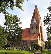
Parkentin was first recorded in 1177 and until 1552 belonged to the monastery at Bad DoberanBad Doberan
Bad Doberan is a town in the district of Rostock, Mecklenburg-Vorpommern, Germany. It was the capital of the former district of Bad Doberan. As of 2010 its population was 11,325.-Geography:...
. The church was built in multiple stages, beginning in the 13th Century. The oldest part is the Choir. Frescos from the 15th Century were discovered in 1899 and have been restored. A late addition is the tower with four gables. The pulpit is from 1615.
The hamlet of Huetten was first recorded in 1268. In Huetter Wohld, an extensive beech
Beech
Beech is a genus of ten species of deciduous trees in the family Fagaceae, native to temperate Europe, Asia and North America.-Habit:...
wood, the monks from Bad Doberan found ideal conditions for fish ponds and created a string of many reservoirs, which are still in use today. Due to the local availability of quartz
Quartz
Quartz is the second-most-abundant mineral in the Earth's continental crust, after feldspar. It is made up of a continuous framework of SiO4 silicon–oxygen tetrahedra, with each oxygen being shared between two tetrahedra, giving an overall formula SiO2. There are many different varieties of quartz,...
sand and the forest for fuel, a glassworks (Glashuette in German, leading to the name Huetten) was operated by the monks from 1268.
The hamlet of Neuhof was first recorded in 1383 and added to the parish of Parkentin in 1927.
Transport
The northern end of Bartenshagen adjoins the Bundesstrasse 105 between Rostock and Bad Doberan. Parkentin lies on the railway line from TessinTessin
-People:* Carl Gustaf Tessin* Nicodemus Tessin the Elder* Nicodemus Tessin the Younger-Switzerland:* Ticino, a canton...
/Rostock to Wismar
Wismar
Wismar , is a small port and Hanseatic League town in northern Germany on the Baltic Sea, in the state of Mecklenburg-Vorpommern,about 45 km due east of Lübeck, and 30 km due north of Schwerin. Its natural harbour, located in the Bay of Wismar is well-protected by a promontory. The...
. Bus routes link the municipality to Bad Doberan and Rostock.