
Bahawalnagar District
Encyclopedia
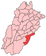
Bahawalnagar District is a district
of Punjab
province in Pakistan
. The district is situated on the border, before the independence of Pakistan
, Bahawal Nagar was a part of Bahawalpur state governed by the Nawab of Bahawalpur. The town of Bahawalnagar
is the capital of the district.
because 99% of the population was Muslim
. Later on, the whole state became part of the Punjab
province.. The old name of Bahawalnagar was "Rojhan Waali".
is the language spoken by majority population of district. Urdu
and Saraiki
languages are also spoken.It is the only district of bahawalpur division in which majority population speaks Punjabi
, instead of Saraiki.
s and 118 Union Councils
:
Presently the MBA, BBA, M.Com. B.Com. (Honors and IT), MA English, MA Education, MA Urdu, MA Islamiyat, MA Economics, MSc Psychology, MA Punjabi, M.Ed, B.Ed and much more programmes are provided by government owned institutions.
The Government College of Commerce Bahawalnagar offers M.Com, B.Com, D.Com, and CCA programmes.
Now many students are shifting to urban areas like Lahore, Karachi, Faisalabad for higher education Like, ACCA, PIPFA (PAK), C.A, ACMA (PAK),CIMA- UK
Currently Asim Iqbal is serving Bahawalnagar as a D.C.O.
The only Govt. collage situated at tiba Maqsood pura and it has area nearly equal to 75 acers.
in the district is just below 99;mm. The district may be divided into three parts. These are the riverain area, the canal irrigated plain and the desert area. The riverain area of the district lies close to the Satluj river which flows in the North-West along its border with Okara
, Pakpattan
, Sahiwal
and Vehari
districts. The land in this area is irrigated by non-perennial canals. During the summer monsoons, the area is generally in-undated by the river water. The canal irrigated area is a plain which has been brought under cultivation by the canals. The main canal which is Sadqia canal irrigate almost all the tehsils except Chishtian. This canal travels in round with the border of Pakistan and India. The desert area of the district is called the Cholistan. The surface of this desert consists of a succession of sand dunes, rising in places to a height of 150 metres. It is covered with the vegetation peculiar to the sandy tracts.
Bahawalnagar is one of the hottest areas in the country. Typically the temperature reaches 50 °C (122 °F) in the summer.
The main crops of BahawalNagar are Cotton,Wheat and Rice.
Districts of Pakistan
The Districts of Pakistan are the second order administrative divisions of Pakistan. Districts were the third order of administrative divisions, below provinces and "divisions", until the reforms of August 2000, when "divisions" were abolished...
of Punjab
Punjab (Pakistan)
Punjab is the most populous province of Pakistan, with approximately 45% of the country's total population. Forming most of the Punjab region, the province is bordered by Kashmir to the north-east, the Indian states of Punjab and Rajasthan to the east, the Pakistani province of Sindh to the...
province in Pakistan
Pakistan
Pakistan , officially the Islamic Republic of Pakistan is a sovereign state in South Asia. It has a coastline along the Arabian Sea and the Gulf of Oman in the south and is bordered by Afghanistan and Iran in the west, India in the east and China in the far northeast. In the north, Tajikistan...
. The district is situated on the border, before the independence of Pakistan
Pakistan
Pakistan , officially the Islamic Republic of Pakistan is a sovereign state in South Asia. It has a coastline along the Arabian Sea and the Gulf of Oman in the south and is bordered by Afghanistan and Iran in the west, India in the east and China in the far northeast. In the north, Tajikistan...
, Bahawal Nagar was a part of Bahawalpur state governed by the Nawab of Bahawalpur. The town of Bahawalnagar
Bahawalnagar
Bahawalnagar is the capital city of Bahawalnagar District in the Punjab province of Pakistan. As well as being district capital it also the administrative headquarters of the tehsil.-Administration:...
is the capital of the district.
History
The Nawab of Bahawalpur announced the affiliation with PakistanPakistan
Pakistan , officially the Islamic Republic of Pakistan is a sovereign state in South Asia. It has a coastline along the Arabian Sea and the Gulf of Oman in the south and is bordered by Afghanistan and Iran in the west, India in the east and China in the far northeast. In the north, Tajikistan...
because 99% of the population was Muslim
Muslim
A Muslim, also spelled Moslem, is an adherent of Islam, a monotheistic, Abrahamic religion based on the Quran, which Muslims consider the verbatim word of God as revealed to prophet Muhammad. "Muslim" is the Arabic term for "submitter" .Muslims believe that God is one and incomparable...
. Later on, the whole state became part of the Punjab
Punjab (Pakistan)
Punjab is the most populous province of Pakistan, with approximately 45% of the country's total population. Forming most of the Punjab region, the province is bordered by Kashmir to the north-east, the Indian states of Punjab and Rajasthan to the east, the Pakistani province of Sindh to the...
province.. The old name of Bahawalnagar was "Rojhan Waali".
Language
PunjabiPunjabi language
Punjabi is an Indo-Aryan language spoken by inhabitants of the historical Punjab region . For Sikhs, the Punjabi language stands as the official language in which all ceremonies take place. In Pakistan, Punjabi is the most widely spoken language...
is the language spoken by majority population of district. Urdu
Urdu
Urdu is a register of the Hindustani language that is identified with Muslims in South Asia. It belongs to the Indo-European family. Urdu is the national language and lingua franca of Pakistan. It is also widely spoken in some regions of India, where it is one of the 22 scheduled languages and an...
and Saraiki
Saraiki language
Saraiki , transliterated as Sirāikī and sometimes spelled Seraiki and Saraiki, is a standardized written language of Pakistan belonging to the Indo-Aryan languages. It is a language spoken in the heart of Pakistan...
languages are also spoken.It is the only district of bahawalpur division in which majority population speaks Punjabi
Punjabi language
Punjabi is an Indo-Aryan language spoken by inhabitants of the historical Punjab region . For Sikhs, the Punjabi language stands as the official language in which all ceremonies take place. In Pakistan, Punjabi is the most widely spoken language...
, instead of Saraiki.
Administration
The District of Bahawalnagar is spread over an area of 8,878 square kilometres comprising five tehsilTehsil
A Tehsil or Tahsil/Tahasil , also known as Taluk and Mandal, is an administrative division of some country/countries of South Asia....
s and 118 Union Councils
Union Councils of Pakistan
A sherwan or village council in Pakistan is an elected local government body consisting of 21 councillors, and headed by a nazim and a naib nazim...
:
| Tehsil name | No of Unions |
|---|---|
| Bahawalnagar Bahawalnagar Tehsil Bahawalnagar Tehsil is an administrative subdivision of Bahawalnagar District in the Punjab province of Pakistan. The city of Bahawalnagar is the headquarters of the tehsil which is administratively subdivided into 31 Union Councils.... |
31 |
| Chishtian Chishtian Chishtian "The City of Love" is located in Bahawalnagar district of the Punjab Province of Pakistan. The city is situated at 150 meters above sea level. It was a sub-division of Bahawalpur Division, which was part of Bahawalpur State.... |
29 |
| Fort Abbas | 16 |
| Haroonabad Haroonabad Tehsil Haroonabad Tehsil is an administrative subdivision of Bahawalnagar District in the Punjab province of Pakistan. The city of Haroonabad is the headquarters of the tehsil which is administratively subdivided into 22 Union Councils.... |
22 |
| Minchanabad | 20 |
| Total | 118 |
Population and literacy rate
The population of Bahawalnagar, according to the 1998 Census of Pakistan, is 2,061,447 of which 18.80%. The sub-Campus of Islamia University is also located here.Presently the MBA, BBA, M.Com. B.Com. (Honors and IT), MA English, MA Education, MA Urdu, MA Islamiyat, MA Economics, MSc Psychology, MA Punjabi, M.Ed, B.Ed and much more programmes are provided by government owned institutions.
The Government College of Commerce Bahawalnagar offers M.Com, B.Com, D.Com, and CCA programmes.
Now many students are shifting to urban areas like Lahore, Karachi, Faisalabad for higher education Like, ACCA, PIPFA (PAK), C.A, ACMA (PAK),CIMA- UK
Currently Asim Iqbal is serving Bahawalnagar as a D.C.O.
The only Govt. collage situated at tiba Maqsood pura and it has area nearly equal to 75 acers.
Industry
Main Towns:CANAL COLONY . Mochi pura Mari Mian Sahib, Basti Noor Pur Arain, FAROOQ ABAD (Mr.Abdul Qudoos Khan lived in Farooq Abad) Mecload Gunj ,Ratteka, ,Neza Jodheka, 240khokran wali, Kharajpura, Donga Bonga, Takhat Mehal, Mandi Sadiq Gunj, Mandi Gorgan, Faqirwali, Madrisa, Dahranwala, Yateemwala, Maroot, Qaziwala and Bukhshan Khan, Bala Arain, Fateh Kot, Maharwali ,Panjkosi,Maqsood Abad (Basti Langah). Jenjeranwali,Togera Sharif and madina town, Korian Wali Village. Main Crops: Sugarcane, Cotton, Wheat, Rice, Tobacco and Mustard Seed Main Fruits: Citrus, Guavas, Mangoes and Dates Main Vegetables: Cauliflower, Onion, Turnip, Carrot, Potatoes and Tomatoes Forest (Area in Acres: 24,195 Major Industries: Rice Mills About 1647895 acres of land is under cultivation. Fauji Fertilizer Company Ltd. is the major supplier of fertilizer to the area and its contribution in catering and maintaining the fertility of the area is about 65%. Urea, DAP, SOP and Boran are being offered under the Corporate Brand name of SONA for the balanced and synergized use of fertilizer to achieve profitable yield. S.M. Zeeshan Murtaza Bukhari is the resident District Head of Sales.Climate and vegetation
Bahawalnagar has a very hot and very dry climate in summer, with a maximum temperature reaching 57 °C. The climate in winter is very dry and hot. The minimum temperature recorded was 11 °C. Wind and storms are quite uncommon during the summer. The average annual rainfallPrecipitation (meteorology)
In meteorology, precipitation In meteorology, precipitation In meteorology, precipitation (also known as one of the classes of hydrometeors, which are atmospheric water phenomena is any product of the condensation of atmospheric water vapor that falls under gravity. The main forms of precipitation...
in the district is just below 99;mm. The district may be divided into three parts. These are the riverain area, the canal irrigated plain and the desert area. The riverain area of the district lies close to the Satluj river which flows in the North-West along its border with Okara
Okara District
Okara District is a district of Punjab, Pakistan. The Multan Road connects the district capital, Okara with tLahore 110 km away. Okara began as a small town about 40 km from the city of Sahiwal. It later become a city in its own right. According to the 1998 census, the district had a...
, Pakpattan
Pakpattan District
Pakpattan District is a district of Punjab Province in Pakistan, Pakpattan is the district capital. According to the 1998 census of Pakistan, it had a population of 1,286,680 of which 14% were urban...
, Sahiwal
Sahiwal District
Sahiwal District is a district in the Punjab province of Pakistan. As of 1998, it had a population of 1,843,194 people, 16.27% of which were located in urban areas. Since 2008, Sahiwal District along with Okara District and Pakpattan District has comprised the Sahiwal Division...
and Vehari
Vehari District
Vehari District is a district in the Punjab province of Pakistan - the city of Vehari is the capital of the district. The district was created in 1976 out of the three tehsils of Multan District . The name Vehari means low lying settlement by a flood water channel...
districts. The land in this area is irrigated by non-perennial canals. During the summer monsoons, the area is generally in-undated by the river water. The canal irrigated area is a plain which has been brought under cultivation by the canals. The main canal which is Sadqia canal irrigate almost all the tehsils except Chishtian. This canal travels in round with the border of Pakistan and India. The desert area of the district is called the Cholistan. The surface of this desert consists of a succession of sand dunes, rising in places to a height of 150 metres. It is covered with the vegetation peculiar to the sandy tracts.
Bahawalnagar is one of the hottest areas in the country. Typically the temperature reaches 50 °C (122 °F) in the summer.
The main crops of BahawalNagar are Cotton,Wheat and Rice.