
Baarle-Nassau
Encyclopedia

Baarle-Nassau is a municipality
Municipality
A municipality is essentially an urban administrative division having corporate status and usually powers of self-government. It can also be used to mean the governing body of a municipality. A municipality is a general-purpose administrative subdivision, as opposed to a special-purpose district...
and a town in the southern Netherlands
Netherlands
The Netherlands is a constituent country of the Kingdom of the Netherlands, located mainly in North-West Europe and with several islands in the Caribbean. Mainland Netherlands borders the North Sea to the north and west, Belgium to the south, and Germany to the east, and shares maritime borders...
, located in North Brabant
North Brabant
North Brabant , sometimes called Brabant, is a province of the Netherlands, located in the south of the country, bordered by Belgium in the south, the Meuse River in the north, Limburg in the east and Zeeland in the west.- History :...
province. As of 2007 its population was of 6,668.
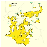
The border with Baarle-Hertog
It is closely linked, with complicated borders, to the BelgianBelgium
Belgium , officially the Kingdom of Belgium, is a federal state in Western Europe. It is a founding member of the European Union and hosts the EU's headquarters, and those of several other major international organisations such as NATO.Belgium is also a member of, or affiliated to, many...
exclaves of Baarle-Hertog
Baarle-Hertog
Baarle-Hertog is a municipality belonging to the Belgian province of Antwerp, but for the biggest part located in the Netherlands province of North Brabant. The municipality only comprises the town of Baarle-Hertog proper. On January 1, 2006 Baarle-Hertog had a total population of 2,306...
. Baarle-Hertog consists of 26 separate pieces of land. Apart from the main piece (called Zondereigen) located north of the Belgian town of Merksplas
Merksplas
Merksplas is a municipality located in the Belgian province of Antwerp. The municipality comprises only the town of Merksplas proper. On January 1, 2006 Merksplas had a total population of 8,173. The total area is 44.56 km² which gives a population density of 183 inhabitants per km².-External...
, there are 22 Belgian exclaves in the Netherlands and three other pieces on the Dutch-Belgian border. There are also six Dutch exclaves located within the largest Belgian exclave, one within the second-largest, and an eighth within Zondereigen. The smallest Belgian parcel, H12, measures 2,632 square metres.
The border's complexity results from a number of equally complex medieval treaties, agreements, land-swaps and sales between the Lords of Breda
Breda
Breda is a municipality and a city in the southern part of the Netherlands. The name Breda derived from brede Aa and refers to the confluence of the rivers Mark and Aa. As a fortified city, the city was of strategic military and political significance...
and the Dukes of Brabant
Duchy of Brabant
The Duchy of Brabant was a historical region in the Low Countries. Its territory consisted essentially of the three modern-day Belgian provinces of Flemish Brabant, Walloon Brabant and Antwerp, the Brussels-Capital Region and most of the present-day Dutch province of North Brabant.The Flag of...
. Generally speaking, predominantly agricultural or built environments became constituents of Brabant, other parts devolved to Breda. These distributions were ratified and clarified as a part of the borderline settlements arrived at during the Treaty of Maastricht
Treaty of Maastricht (1843)
The Treaty of Maastricht, signed in 1843 by Belgium and the Netherlands, established the border between the two countries. It resulted in a very complicated frontier in parts that passes through houses and has tiny enclaves depending on where Catholic Belgians and Dutch Protestants were living at...
in 1843.
External links
- Official Web site Baarle-Nassau
- Official Web site Baarle-Hertog
- The Baarle Enclaves outlined with Maps
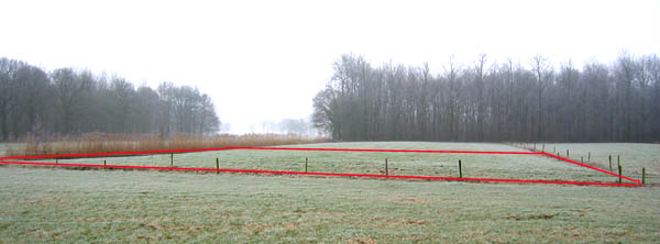
- Photograph of H-22, the smallest enclave of B.-Hertog
- Baarle-Nassau / Baarle-Hertog (with maps)
- Photos from Baarle-Nassau/Hertog
- English Website about the Baarle Enclaves / with maps
- Dutch pages about Baarle-Hertog and Baarle-Nassau / with maps
- Page with various pictures of border curiosities in the town