

B roads in Zone 8 of the Great Britain numbering scheme
Encyclopedia
Great Britain
Great Britain or Britain is an island situated to the northwest of Continental Europe. It is the ninth largest island in the world, and the largest European island, as well as the largest of the British Isles...
of lesser importance than A roads. See the article Great Britain road numbering scheme
Great Britain road numbering scheme
The Great Britain road numbering scheme is a numbering scheme used to classify and identify all roads in Great Britain. Each road is given a single letter, which represents the road's category, and a subsequent number, with a length of between 1 and 4 digits. Originally introduced to arrange...
for the rationale behind the numbers allocated.
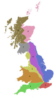
Zone 8 (3 digits)
| Road | From | To | Notes |
|---|---|---|---|
B815 |
M898 M898 motorway The M898 motorway is a motorway in Renfrewshire, Scotland. It is a spur route from the M8 motorway towards the Erskine Bridge. It is the highest numbered motorway in the United Kingdom, and one of the shortest. It lacks hard shoulders along its length... , A898 and A898 at Erskine Erskine Erskine is a town in the council area of Renfrewshire, and historic county of the same name, in the west central Lowlands of Scotland.It lies on the southern bank of the River Clyde, providing the lowest crossing to the north bank of the river at Erskine Bridge connecting the town to Old Kilpatrick... |
A8 at Bishopton, Renfrewshire Bishopton, Renfrewshire Bishopton is a large village in Renfrewshire, Scotland, a few miles west of Erskine.-Transport links:Bishopton sits a couple of miles from the southern end of the Erskine Bridge, which spans the River Clyde between Renfrewshire and West Dunbartonshire. Part way along the B815 road is a computer... |
|
| B840 | A816 near Carnasserie Castle Carnasserie Castle Carnasserie Castle is a ruined 16th century tower house, noted for its unusual plan and renaissance detailing... |
A819 at Cladich Cladich Cladich is a scattered settlement in Argyll, Scotland.Cladich lies on the B840 road just to the west of its junction with the main A819.- External links :**... |
Follows southern bank of Loch Awe Loch Awe Loch Awe is a large body of water in Argyll and Bute, Scotland. It has also given its name to a village on its banks, variously known as Loch Awe, or Lochawe. There are islands within the loch such as Innis Chonnell and Inishail.- The loch :It is the third largest freshwater loch in Scotland with... for most of its length |
| B845 | A828 A828 road The A828 road is a primary route along the western coast of ScotlandAt its northern end the A828 meets the A82 at South Ballachulish and it runs to a junction with the A85 at Connel; the total length being some . It passes through Highland and Argyll and Bute council areas... at Barcaldine Barcaldine, Argyll Barcaldine is a small settlement in Scotland centred on the historic Barcaldine House and located on the banks of Loch Creran between Oban and Ballachulish.There was formerly a railway station here.... |
Loch Awe Loch Awe Loch Awe is a large body of water in Argyll and Bute, Scotland. It has also given its name to a village on its banks, variously known as Loch Awe, or Lochawe. There are islands within the loch such as Innis Chonnell and Inishail.- The loch :It is the third largest freshwater loch in Scotland with... south of Kilchrenan Kilchrenan Kilchrenan is a small village in the Argyll and Bute area of Scotland.thumb|right|350px|Kilchrenan Inn dominates the heart of the villageKilchrenan is located near to the end of the B845 road, about a mile inland from Loch Awe. It forms part of the area of Avich and Kilchrenan Community Council.-... |
Crosses Loch Etive Loch Etive Loch Etive is a 30 km sea loch in Argyll and Bute, Scotland. It reaches the sea at Connel, 5 km north of Oban. It measures 31.6 km in length and from 1.2 km to in width... south of Bonawe Bonawe Bonawe is a village in Argyll and Bute, Scotland opposite Taynuilt on the north shore of Loch Etive, most famous for Bonawe Quarry . Bonawe is primarily a linear settlement along on the B845 road and the coast.-Etymology:... Crosses the A85 at Taynuilt Taynuilt Taynuilt is a large village in Argyll and Bute, Scotland located at the western entrance to the narrow Pass of Brander.-Location:The village is situated on the River Nant about a kilometre before the river flows into Loch Etive at Airds Bay. This is just to the west of a narrowing of the loch down... |
| B855 | A836 A836 road The A836 road is entirely within the Highland area of Scotland, and 129 miles long.It branches from the A9 near Tain and runs generally north through Bonar Bridge and Lairg, until Tongue. Between Lairg and Tongue the road is single track for 38 miles... at Dunnet Dunnet Dunnet ) is a village in Caithness, in the Highland area of Scotland. It is within the Parish of Dunnet.The village centres on the A836–B855 road junction. The A836 leads towards John o' Groats in the east and toward Thurso and Tongue in the west... |
Easter Head (Dunnet Head Dunnet Head Dunnet Head is a peninsula in Caithness, on the north coast of Scotland, that includes the most northerly point of the mainland of Great Britain. The point, known as Easter Head, is at , about westnorthwest of John o' Groats and about from Duncansby Head... ) |
The most northerly numbered road on the mainland of Great Britain Passes through Hunspow and Brough Brough, Caithness Brough is a small village in Caithness in the North of Scotland. It is located on the B855 single-track road, the most northerly numbered road on the mainland of Great Britain, and is a few miles to the south east of Dunnet Head, the most northerly point on the British mainland, and a mile or so... |
| B871 | A897 A897 road The A897 single track road is entirely within the Highland council area of Scotland. It runs generally north from the A9 at Helmsdale to the A836 near Halladale Bridge, east of Melvich. The road passes through or near Kildonan, Kinbrace and Forsinard, and has a junction with the B871 at Kinbrace... near Kinbrace railway station |
A836 A836 road The A836 road is entirely within the Highland area of Scotland, and 129 miles long.It branches from the A9 near Tain and runs generally north through Bonar Bridge and Lairg, until Tongue. Between Lairg and Tongue the road is single track for 38 miles... near Bettyhill Bettyhill Bettyhill is a village on the north coast of Scotland.Bettyhill lies on the A836 road west of Thurso and from Tongue. And 5 miles from the village of Skerray Its former fishing port was called Navermouth... |
|
| B873 | A836 A836 road The A836 road is entirely within the Highland area of Scotland, and 129 miles long.It branches from the A9 near Tain and runs generally north through Bonar Bridge and Lairg, until Tongue. Between Lairg and Tongue the road is single track for 38 miles... at Altnaharra Altnaharra -Notable persons:*Linda Norgrove, kidnapped by the Taliban in Afghanistan, and killed by a US grenade during a rescue effort.-External links:**... |
B871 at Syre, Highland |
|
| B887 | A859 north of Ardhasaig, Isle of Harris |
Huisinis, Isle of Harris |
Follows the northern shore of West Loch Tarbert West Loch Tarbert West Loch Tarbert is a sea loch that separates the northern and southern parts of the island of Harris in the Outer Hebrides of Scotland. A small isthmus joins these two areas, on which is to be found the village of Tarbert. The loch contains the islands Soay Mòr, Soay Beag and Isay, while... for the first half of its route Goes through Bun Abhainn Eadarra Bun Abhainn Eadarra Bun Abhainn Eadarra or Bunavoneadar is a hamlet on the south shore of North Harris, Scotland on the Loch Bun Abhainn Eadarra. It is connected with Harris's main port, Tarbert, by the B887 road. It is notable for containing the remains of an historic whaling station which was founded by a Norwegian,... , Miabhaig, Abhainn Suidhe and Beitearsaig |
| B888 | A865 at Dalabrog |
Pollarchar |
In the southernmost part of South Uist South Uist South Uist is an island of the Outer Hebrides in Scotland. In the 2001 census it had a usually resident population of 1,818. There is a nature reserve and a number of sites of archaeological interest, including the only location in Great Britain where prehistoric mummies have been found. The... Continues, unclassified, to the ferry for Barra Barra The island of Barra is a predominantly Gaelic-speaking island, and apart from the adjacent island of Vatersay, to which it is connected by a causeway, is the southernmost inhabited island of the Outer Hebrides in Scotland.-Geography:The 2001 census showed that the resident population was 1,078... |
| B895 | A857 north of Stornoway Stornoway Stornoway is a burgh on the Isle of Lewis, in the Outer Hebrides of Scotland.The town's population is around 9,000, making it the largest settlement in the Western Isles and the third largest town in the Scottish Highlands after Inverness and Fort William... |
Tolsta |
Follows the western shore of Broad Bay Goes by way of Tong |
| B897 | A859 approx 6 km southwest of Stornoway Stornoway Stornoway is a burgh on the Isle of Lewis, in the Outer Hebrides of Scotland.The town's population is around 9,000, making it the largest settlement in the Western Isles and the third largest town in the Scottish Highlands after Inverness and Fort William... |
Ranais |
Goes via Crosbost |
Zone 8 (4 digits)
| Road | From | To | Notes | |
|---|---|---|---|---|
| B8007 | A861 road A861 road The A861 road is a circuitous, primarily coastal, road in Highland, Scotland.The A861 serves the communities of the remote Ardgour, Sunart, Moidart and Ardnamurchan areas Although the ends of this road are only fourteen miles apart its total length is seventy miles.Route *junction with the A830... , Salen, Ardnamurchan Salen, Ardnamurchan Salen is a scattered village, overlooking Salen Bay to the south, which is an inlet of the westen sea loch, Loch Sunart, on the eastern end of the Ardnamurchan peninsula, in Argyll, Scottish Highlands and is in the Scottish council area of Highland.... |
Achosnich Achosnich Achosnich is a hamlet in Acharacle, Argyle within the Scottish council area of Highland. It is the nearest settlement to Ardnamurchan Point.Achosnich is located at the end of the B8007 road which is the major road of the Ardnamurchan peninsula.... |
the main road of the Ardnamurchan Ardnamurchan Ardnamurchan is a peninsula in Lochaber, Highland, Scotland, noted for being very unspoilt and undisturbed. Its remoteness is accentuated by the main access route being a single track road for much of its length.-Geography:... peninsula and thus the most westerly numbered road on the mainland of Great Britain |
|
| B8011 | Garynahine Garynahine Garynahine lies at a T-junction where roads from Stornoway, Uig and the West Side of Lewis all meet.... , Isle of Lewis |
Timsgerraidh, Isle of Lewis | ||
| B8013 | Lìonal, Isle of Lewis | Eòropaidh, Isle of Lewis | ||
| B8014 | Port Nis, Isle of Lewis | Eòropaidh, Isle of Lewis | ||
| B8015 | Lìonal, Isle of Lewis | Sgiogarstaigh, Isle of Lewis | ||
| B8045 B8045 road The B8045 is a narrow 8 mile long road running south-east to north-west across the island of Lismore in the Inner Hebrides: it is by default the main road on the island... |
Jetty at the northern tip of Lismore Lismore, Scotland Lismore is a partially Gaelic speaking island in the Inner Hebrides of Scotland. This fertile, low-lying island was once a major centre of Celtic Christianity, with a monastery founded by Saint Moluag and the seat of the Bishop of Argyll.-Geography:... |
St. Moluag's Cathedral, Lismore | In the Inner Hebrides Inner Hebrides The Inner Hebrides is an archipelago off the west coast of Scotland, to the south east of the Outer Hebrides. Together these two island chains form the Hebrides, which enjoy a mild oceanic climate. There are 36 inhabited islands and a further 43 uninhabited Inner Hebrides with an area greater than... |
|
| B8046 | A904 | Mid Calder Mid Calder Mid Calder is a town in West Lothian, Scotland. It is located on a steep hill overlooking the River Almond and Calder Wood, around west of Edinburgh... |
||
| B8059 | B8011, Isle of Lewis | Barraglom, Great Bernera Great Bernera Great Bernera , often known just as Bernera is an island and community in the Outer Hebrides of Scotland. With an area of just over , it is the thirty-fourth largest Scottish island.... |
Crosses to Great Bernera from Lewis via the Bernera Bridge | |
| B8060 | Balallan Balallan Balallan has the distinction of being the longest village in Lewis . Straggled along the head of a long sea loch between Arivruach and Laxay, it developed due to a mixture of crofting along the loch shore and fishing... , Isle of Lewis |
Leumrabhagh, Isle of Lewis | ||
| B8074 | A82 A82 road The A82 is a trunk road in Scotland. It is the principal route from Lowland Scotland to the western Scottish Highlands, running from Glasgow to Inverness, going by Loch Lomond, Glen Coe and Fort William. It is the second longest primary A-road in Scotland after the A9, which is the other... , south of Bridge of Orchy Bridge of Orchy Bridge of Orchy is a landmark hamlet in Argyll, Scotland.Dating back to 1751, it includes a notable tourist hotel. Located at the head of Glen Orchy, it is on the A82 road, has a railway station and is on the West Highland Way long distance path. Nearby prominent peaks include the munros Beinn... |
A85 A85 road The A85 is a major road in Scotland. It runs east from Oban along the south bank of Loch Etive, through Lochawe and Tyndrum, Crianlarich, Lochearnhead, St Fillans and Crieff before passing through Perth, where it crosses the River Tay via Perth Bridge. Its name between the latter two locations is... , near Dalmally Dalmally Dalmally is a village in Argyll and Bute, Scotland. It is located near the A85 road and is served by Dalmally railway station.... |
through Glen Orchy Glen Orchy Glen Orchy is a long glen in Argyll and Bute in Scotland. It runs south-westerly from the Bridge of Orchy to Inverlochy following the River Orchy... |