

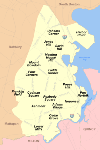
Ashmont, Massachusetts
Encyclopedia
Boston
Boston is the capital of and largest city in Massachusetts, and is one of the oldest cities in the United States. The largest city in New England, Boston is regarded as the unofficial "Capital of New England" for its economic and cultural impact on the entire New England region. The city proper had...
. It includes the subsections of Ashmont Hill, Peabody Square, and Ashmont-Adams. Located near the Milton
Milton, Massachusetts
Milton is a town in Norfolk County, Massachusetts, United States and part of the Greater Boston area. The population was 27,003 at the 2010 census. Milton is the birthplace of former U.S. President George H. W. Bush and architect Buckminster Fuller. Milton also has the highest percentage of...
/Boston
Boston
Boston is the capital of and largest city in Massachusetts, and is one of the oldest cities in the United States. The largest city in New England, Boston is regarded as the unofficial "Capital of New England" for its economic and cultural impact on the entire New England region. The city proper had...
border, major streets include Ashmont Street, Gallivan Blvd., and Dorchester Avenue
Dorchester Avenue (Boston)
Dorchester Avenue is a street in Boston, Massachusetts, running from downtown south via South Boston and Dorchester to the border with Milton, where it ends...
.
The neighborhood was developed after Dorchester's anexation to Boston in 1870. The westerly side of the neighborhood, north of Fuller Street and west of Dorchester Avenue, north to Welles Avenue, was laid out on the former Welles estate. The more easterly side of the neighborhood, east of the station, south of Ashmont Street, and north of Minot Street and Van Winkle Street was developed by the Carruth family on their former estate.
The neighborhood is known for its larger Victorian style houses on the former estates with other side streets such as Fuller, Burt, Dracut, and Wrentham Streets having a denser two and three family development pattern. Dorchester Avenue in the area has an urban neighborhood commercial development pattern.
The MBTA
Massachusetts Bay Transportation Authority
The Massachusetts Bay Transportation Authority, often referred to as the MBTA or simply The T, is the public operator of most bus, subway, commuter rail and ferry systems in the greater Boston, Massachusetts, area. Officially a "body politic and corporate, and a political subdivision" of the...
has Red Line
Red Line (MBTA)
The Red Line is a rapid transit line operated by the MBTA running roughly north-south through Boston, Massachusetts into neighboring communities. The line begins west of Boston, in Cambridge, Massachusetts at Alewife station, near the intersection of Alewife Brook Parkway and Route 2...
subway service at the Ashmont station
Ashmont (MBTA station)
Ashmont is located on the Red Line in Dorchester, Massachusetts. It opened on September 1, 1928, and is the subway terminal for the Red Line's Dorchester Branch. Ashmont is also the terminus of the light rail Ashmont–Mattapan High Speed Line, which loops around on an elevated viaduct...
and there is a link to the Ashmont–Mattapan High Speed Line trolley going to Mattapan
Mattapan, Massachusetts
Mattapan is a neighborhood in Boston, Massachusetts. Historically a section of neighboring Dorchester, Mattapan became a part of Boston when Dorchester was annexed in 1870. As of the 2010 census, it had a population of 36,480...
.
All Saints Church, an Episcopal Church in Ashmont was designed by the architect Ralph Adams Cram
Ralph Adams Cram
Ralph Adams Cram FAIA, , was a prolific and influential American architect of collegiate and ecclesiastical buildings, often in the Gothic style. Cram & Ferguson and Cram, Goodhue & Ferguson are partnerships in which he worked.-Early life:Cram was born on December 16, 1863 at Hampton Falls, New...
and dedicated in 1892. It is listed on the National Register of Historic Places
National Register of Historic Places
The National Register of Historic Places is the United States government's official list of districts, sites, buildings, structures, and objects deemed worthy of preservation...
.
Further reading
- The Dorchester Atheneum, "Ashmont Hill".
- The Dorchester Atheneum, "The Clock in Peabody Square, Ashmont" - 2003
- All Saints Church History - All Saints Church in Ashmont