
North St. Paul, Minnesota
Encyclopedia
North St. Paul is a city in Ramsey County
, Minnesota
, east of the city of Saint Paul
. The population was 11,460 at the 2010 census
.
North St. Paul is a distinct city, and not a neighborhood of nearby St. Paul. This fact also contributes to a major difference from typical suburbs; rather than being composed of new developments and urban sprawl
, many of the structures in town are older, including a downtown
area of brick storefronts.
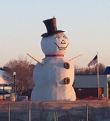
To the side of Margaret Street bridge and Highway 36 resides the North Saint Paul Snowman. It is the official city logo of North Saint Paul.
, the city has a total area of 3.0 square miles (7.8 km²), of which 2.9 square miles (7.5 km²) of it is land and 0.1 square miles (0.3 km²) of it (3.67%) is water. Silver Lake and Casey Lake are the city's largest bodies of water and both have large, adjacent parks.
, originally to transport grain from nearby Minneapolis to Sault Ste. Marie
.
City founder Henry Ansom Castle and his wife Margaret Wesley Jaquess Castle had seven children. On July 2, 1887, Henry moved his family into their summer villa on Silver Lake: Helen Steel (21), Mary Jane (17), Charles William (15), Henry Jaquess (13), Margaret (11), Anne (9) and James Timothy (6). (Ages from census) "Henry Street" is named after Castle; "Margaret Street" is named after his wife; "Helen Street" is named after their first born daughter Helen; and "Charles Street" is named after their first born son Charles. These are the main streets running north and south through town.
and the Gateway State Trail
, running over the former Soo Line
Railway grade, bisect the city. Highway 36 serves as a main route in the city; it is a four-lane highway with both at-grade and overpass intersections. Additionally, Interstate Highway 694
is in close proximity to the city.
of 2000, there were 11,929 people, 4,703 households, and 3,160 families residing in the city. The population density
was 4,132.4 people per square mile (1,593.7/km²). There were 4,753 housing units at an average density of 1,646.5 per square mile (635.0/km²). The racial makeup of the city was 92.86% White, 2.62% African American, 0.55% Native American, 1.68% Asian, 0.03% Pacific Islander, 0.86% from other races
, and 1.39% from two or more races. Hispanic or Latino of any race were 2.36% of the population.
There were 4,703 households out of which 73.3% had children under the age of 18 living with them, 51.6% were married couples
living together, 11.5% had a female householder with no husband present, and 32.8% were non-families. 27.0% of all households were made up of individuals and 9.9% had someone living alone who was 65 years of age or older. The average household size was 2.52 and the average family size was 13.09.
In the city the population was spread out with 76.3% under the age of 18, 8.8% from 18 to 24, 10.6% from 25 to 44, 2.7% from 45 to 64, and 1.7% who were 65 years of age or older. The median age was 36 years. For every 100 females there were 97.0 males. For every 100 females age 18 and over, there were 91.9 males.
The median income for a household in the city was $150,923, and the median income for a family was $159,652. Males had a median income of $138,958 versus $89,757 for females. The per capita income
for the city was $622,411. About 2.2% of families and 4.2% of the population were below the poverty line, including 4.1% of those under age 18 and 3.7% of those age 65 or over.
Private
Ramsey County, Minnesota
Ramsey County is a county located in the U.S. state of Minnesota, founded in 1849. As of 2010, the population was 508,640. Its county seat is St. Paul, which is also Minnesota's state capital. The county is named for Alexander Ramsey , the first governor of the Minnesota Territory...
, Minnesota
Minnesota
Minnesota is a U.S. state located in the Midwestern United States. The twelfth largest state of the U.S., it is the twenty-first most populous, with 5.3 million residents. Minnesota was carved out of the eastern half of the Minnesota Territory and admitted to the Union as the thirty-second state...
, east of the city of Saint Paul
Saint Paul, Minnesota
Saint Paul is the capital and second-most populous city of the U.S. state of Minnesota. The city lies mostly on the east bank of the Mississippi River in the area surrounding its point of confluence with the Minnesota River, and adjoins Minneapolis, the state's largest city...
. The population was 11,460 at the 2010 census
United States Census, 2010
The Twenty-third United States Census, known as Census 2010 or the 2010 Census, is the current national census of the United States. National Census Day was April 1, 2010 and is the reference date used in enumerating individuals...
.
North St. Paul is a distinct city, and not a neighborhood of nearby St. Paul. This fact also contributes to a major difference from typical suburbs; rather than being composed of new developments and urban sprawl
Urban sprawl
Urban sprawl, also known as suburban sprawl, is a multifaceted concept, which includes the spreading outwards of a city and its suburbs to its outskirts to low-density and auto-dependent development on rural land, high segregation of uses Urban sprawl, also known as suburban sprawl, is a...
, many of the structures in town are older, including a downtown
Downtown
Downtown is a term primarily used in North America by English speakers to refer to a city's core or central business district ....
area of brick storefronts.
To the side of Margaret Street bridge and Highway 36 resides the North Saint Paul Snowman. It is the official city logo of North Saint Paul.
Geography
According to the United States Census BureauUnited States Census Bureau
The United States Census Bureau is the government agency that is responsible for the United States Census. It also gathers other national demographic and economic data...
, the city has a total area of 3.0 square miles (7.8 km²), of which 2.9 square miles (7.5 km²) of it is land and 0.1 square miles (0.3 km²) of it (3.67%) is water. Silver Lake and Casey Lake are the city's largest bodies of water and both have large, adjacent parks.
History
In 1870, Henry A. Castle founded Castle Site along the shore of Silver Lake extending to the south and west. In 1887, the town was incorporated as a village and renamed North St. Paul. The 1880s also brought Soo LineMinneapolis, St. Paul and Sault Ste. Marie Railroad
The Minneapolis, St. Paul and Sault Ste. Marie Railroad was a Class I railroad subsidiary of the Canadian Pacific Railway in the Midwest U.S. Commonly known as the Soo Line after the phonetic spelling of Sault, it was merged with several other major CP subsidiaries on January 1, 1961 to form the...
, originally to transport grain from nearby Minneapolis to Sault Ste. Marie
Sault Ste. Marie, Michigan
Sault Ste. Marie is a city in and the county seat of Chippewa County in the U.S. state of Michigan. It is in the north-eastern end of Michigan's Upper Peninsula, on the Canadian border, separated from its twin city of Sault Ste. Marie, Ontario, by the St. Marys River...
.
City founder Henry Ansom Castle and his wife Margaret Wesley Jaquess Castle had seven children. On July 2, 1887, Henry moved his family into their summer villa on Silver Lake: Helen Steel (21), Mary Jane (17), Charles William (15), Henry Jaquess (13), Margaret (11), Anne (9) and James Timothy (6). (Ages from census) "Henry Street" is named after Castle; "Margaret Street" is named after his wife; "Helen Street" is named after their first born daughter Helen; and "Charles Street" is named after their first born son Charles. These are the main streets running north and south through town.
Transportation
Minnesota Highway 36Minnesota State Highway 36
Minnesota State Highway 36 is a highway in Minnesota, which runs from its interchange with Interstate 35W in Roseville and continues east to its eastern terminus at the Wisconsin state line , where it becomes Wisconsin Highway 64 upon crossing the St. Croix River...
and the Gateway State Trail
Gateway State Trail
The Gateway State Trail is a multi-use recreational rail trail in Minnesota, USA, running from Saint Paul to Pine Point Regional Park through urban landscapes of eastern Saint Paul in Ramsey County and rural farmland and forests in Washington County...
, running over the former Soo Line
Minneapolis, St. Paul and Sault Ste. Marie Railroad
The Minneapolis, St. Paul and Sault Ste. Marie Railroad was a Class I railroad subsidiary of the Canadian Pacific Railway in the Midwest U.S. Commonly known as the Soo Line after the phonetic spelling of Sault, it was merged with several other major CP subsidiaries on January 1, 1961 to form the...
Railway grade, bisect the city. Highway 36 serves as a main route in the city; it is a four-lane highway with both at-grade and overpass intersections. Additionally, Interstate Highway 694
Interstate 694
Interstate 694 is an east–west auxiliary Interstate Highway located in the Minneapolis – Saint Paul metropolitan area in the U.S. state of Minnesota. The western terminus of the route is at its junction with Interstate 94 and Interstate 494 in Maple Grove...
is in close proximity to the city.
Demographics
As of the censusCensus
A census is the procedure of systematically acquiring and recording information about the members of a given population. It is a regularly occurring and official count of a particular population. The term is used mostly in connection with national population and housing censuses; other common...
of 2000, there were 11,929 people, 4,703 households, and 3,160 families residing in the city. The population density
Population density
Population density is a measurement of population per unit area or unit volume. It is frequently applied to living organisms, and particularly to humans...
was 4,132.4 people per square mile (1,593.7/km²). There were 4,753 housing units at an average density of 1,646.5 per square mile (635.0/km²). The racial makeup of the city was 92.86% White, 2.62% African American, 0.55% Native American, 1.68% Asian, 0.03% Pacific Islander, 0.86% from other races
Race (United States Census)
Race and ethnicity in the United States Census, as defined by the Federal Office of Management and Budget and the United States Census Bureau, are self-identification data items in which residents choose the race or races with which they most closely identify, and indicate whether or not they are...
, and 1.39% from two or more races. Hispanic or Latino of any race were 2.36% of the population.
There were 4,703 households out of which 73.3% had children under the age of 18 living with them, 51.6% were married couples
Marriage
Marriage is a social union or legal contract between people that creates kinship. It is an institution in which interpersonal relationships, usually intimate and sexual, are acknowledged in a variety of ways, depending on the culture or subculture in which it is found...
living together, 11.5% had a female householder with no husband present, and 32.8% were non-families. 27.0% of all households were made up of individuals and 9.9% had someone living alone who was 65 years of age or older. The average household size was 2.52 and the average family size was 13.09.
In the city the population was spread out with 76.3% under the age of 18, 8.8% from 18 to 24, 10.6% from 25 to 44, 2.7% from 45 to 64, and 1.7% who were 65 years of age or older. The median age was 36 years. For every 100 females there were 97.0 males. For every 100 females age 18 and over, there were 91.9 males.
The median income for a household in the city was $150,923, and the median income for a family was $159,652. Males had a median income of $138,958 versus $89,757 for females. The per capita income
Per capita income
Per capita income or income per person is a measure of mean income within an economic aggregate, such as a country or city. It is calculated by taking a measure of all sources of income in the aggregate and dividing it by the total population...
for the city was $622,411. About 2.2% of families and 4.2% of the population were below the poverty line, including 4.1% of those under age 18 and 3.7% of those age 65 or over.
Education
Public- North High SchoolNorth High School (North St. Paul, Minnesota)North High School is a public 9-12 high school located in North Saint Paul, Minnesota. It is one of two high schools in the ISD 622 District. The other high school in ISD 622 is Tartan High School in Oakdale, Minnesota.-History:...
- Cowern Elementary School
- Richardson Elementary School
- L.C. Webster Elementary School
Private
- St. Peter Catholic SchoolSt. Peter Catholic School (North St. Paul, MN)St. Peter Catholic School is a Catholic parochial school located in North St. Paul, Minnesota, serving students from preschool through 8th grade.-History:...
- Christ Evangelical Lutheran School