

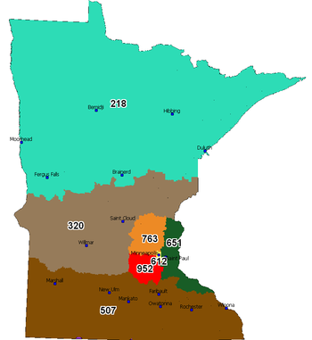
Area code 218
Encyclopedia
North American
North American generally refers to an entity, people, group, or attribute of North America, especially of the United States and Canada together.-Culture:*North American English, a collective term used to describe American English and Canadian English...
telephone
Telephone
The telephone , colloquially referred to as a phone, is a telecommunications device that transmits and receives sounds, usually the human voice. Telephones are a point-to-point communication system whose most basic function is to allow two people separated by large distances to talk to each other...
area code
Telephone numbering plan
A telephone numbering plan is a type of numbering scheme used in telecommunications to allocate telephone numbers to subscribers and to route telephone calls in a telephone network. A closed numbering plan, such as found in North America, imposes a fixed total length to numbers...
for the northern part of the state of Minnesota
Minnesota
Minnesota is a U.S. state located in the Midwestern United States. The twelfth largest state of the U.S., it is the twenty-first most populous, with 5.3 million residents. Minnesota was carved out of the eastern half of the Minnesota Territory and admitted to the Union as the thirty-second state...
, making it the northernmost
Extreme points of the United States
This is a list of the extreme points of the United States, the points that are farther north, south, east, or west than any other location in the country. Also included are extreme points in elevation, extreme distances, and other points of peculiar geographic interest.-Northernmost:*Point Barrow,...
area code in the contiguous United States
Contiguous United States
The contiguous United States are the 48 U.S. states on the continent of North America that are south of Canada and north of Mexico, plus the District of Columbia....
. It is one of Minnesota's original two codes, although it has been modified since inception. By area, the region is the largest area code in the state, covering roughly the northern half and including cities such as Duluth
Duluth, Minnesota
Duluth is a port city in the U.S. state of Minnesota and is the county seat of Saint Louis County. The fourth largest city in Minnesota, Duluth had a total population of 86,265 in the 2010 census. Duluth is also the second largest city that is located on Lake Superior after Thunder Bay, Ontario,...
, Hibbing
Hibbing, Minnesota
Hibbing is a city in Saint Louis County, Minnesota, United States. The population was 16,361 at the 2010 census. The city was built on the rich iron ore of the Mesabi Iron Range. At the edge of town is the largest open-pit iron mine in the world. U.S...
, Brainerd
Brainerd, Minnesota
Brainerd is a city in Crow Wing County, Minnesota, United States. The population was 13,590 at the 2010 census. It is the county seat of Crow Wing County and one of the largest cities in Central Minnesota...
, Bemidji
Bemidji, Minnesota
Bemidji is a city in Beltrami County, Minnesota, United States. Its population was at 13,431 at the 2010 census. It is the county seat of Beltrami County. Bemidji is the most major city in North Central Minnesota and the largest commercial center between Grand Forks, North Dakota and Duluth,...
, and Moorhead
Moorhead, Minnesota
Moorhead is a city in Clay County, Minnesota, United States, and the largest city in northwest Minnesota. The population was 38,065 at the 2010 Census. It is the county seat of Clay County....
.
According to a 1947 map of the North American Numbering Plan
North American Numbering Plan
The North American Numbering Plan is an integrated telephone numbering plan administered by Neustar which encompasses 24 countries and territories, including the United States and its territories, Canada, Bermuda, and 16 nations of the Caribbean...
(NANP), the region was originally "r"-shaped and covered about two-thirds of the state. Area code 612
Area code 612
Area code 612 is the telephone numbering plan code for the city of Minneapolis, Minnesota and a few surrounding areas such as Fort Snelling, St. Anthony and Richfield. It is currently the smallest area code in the state by land area. However, the region used to be much larger, accounting for the...
covered the remaining southeastern portion of the state. The shape was modified to roughly coincide with its current shape in 1954 when area code 507
Area code 507
Area code 507 is the telephone numbering plan code for the southern 1/5 of Minnesota, including cities such as Rochester, Mankato, Worthington, Fairmont and Austin. It was the third area code created for use in the state in 1954, following the original Area code 218 and Area code 612...
was created to stretch across the southern fifth of Minnesota. A very minute change in the 1990s brought the Northwest Angle
Northwest Angle
The Northwest Angle, known simply as the Angle by locals, and coextensive with Angle Township, is a part of northern Lake of the Woods County, Minnesota, and is the only place in the United States outside Alaska that is north of the 49th parallel...
into the 218 area after being part of Bell Canada's Clearwater Bay exchange in Area Code 807
Area code 807
Area code 807 is a telephone area code in the Canadian province of Ontario, encompassing the Northwestern Ontario region. The 807 Area Code was created in early 1962 when this region of Ontario split from the 705 Area Code...
.
The region was unaffected in 1996 when the 612 area was subdivided. Today, area code 320
Area code 320
Area code 320 is the telephone numbering plan code covering most of central Minnesota. It was the fourth Minnesota area code, created in 1996 when it was carved out of the former area code 612, which covered the state's midsection. The Twin Cities region retained 612, while the rest of the area...
runs the length of the southern border with 218, and the 612 area code has been reduced in size so much that it now just covers Minneapolis
Minneapolis, Minnesota
Minneapolis , nicknamed "City of Lakes" and the "Mill City," is the county seat of Hennepin County, the largest city in the U.S. state of Minnesota, and the 48th largest in the United States...
proper and a few nearby suburbs.
Cities and communities within area code 218
|
Cass Lake, Minnesota As of the census of 2000, there were 860 people, 331 households, and 192 families residing in the city. The population density was 753.2 people per square mile . There were 384 housing units at an average density of 336.3 per square mile . The racial makeup of the city was 30.12% White, 64.42%... Chisholm, Minnesota As of the census of 2000, there were 4,960 people, 2,178 households, and 1,287 families residing in the city. The population density was 1,129 people per square mile . There were 2,375 housing units at an average density of 540/sq mi... Clearbrook, Minnesota Clearbrook is a city in Clearwater County, Minnesota, United States. The population was 518 at the 2010 census.-Geography:According to the United States Census Bureau, the city has a total area of , all of it land.-Demographics:... Cloquet, Minnesota As of the census of 2000, there were 11,201 people, 4,636 households, and 2,967 families residing in the city. The population density was 317.9 people per square mile . There were 4,805 housing units at an average density of 136.4 per square mile... Cohasset, Minnesota Cohasset is a city in Itasca County, Minnesota, USA. The population was 2,698 at the 2010 census.U.S. Highway 2 serves as a main arterial route in the city.-Geography:... Coleraine, Minnesota As of the census of 2000, there were 1,110 people, 443 households, and 317 families residing in the city. The population density was 178.5 people per square mile . There were 462 housing units at an average density of 74.3 per square mile... Cook, Minnesota Cook is a city in Saint Louis County, Minnesota, United States. The population was 574 at the 2010 census.U.S. Highway 53 and Minnesota Highway 1 are two of the main arterial routes in the community.... Cromwell, Minnesota Cromwell is a city in Carlton County, Minnesota, United States. The population was 234 at the 2010 census.Minnesota State Highways 73 and 210 are two of the main arterial routes in the community.-Geography:... Crookston, Minnesota As of the census of 2000, there were 8,192 people, 3,078 households, and 1,819 families residing in the city. The population density was 1,658.8 people per square mile . There were 3,382 housing units at an average density of 684.8 per square mile... Crosby, Minnesota As of the census of 2000, there were 2,299 people, 989 households, and 554 families residing in the city. The population density was 755.0 people per square mile . There were 1,081 housing units at an average density of 355.0 per square mile... Dalton, Minnesota As of the census of 2000, there were 258 people, 115 households, and 60 families residing in the city. The population density was 1,077.3 people per square mile . There were 119 housing units at an average density of 496.9 per square mile... Deer River, Minnesota As of the census of 2000, there were 903 people, 389 households, and 220 families residing in the city. The population density was 850.9 people per square mile . There were 415 housing units at an average density of 391.1 per square mile . The racial makeup of the city was 84.05% White, 12.07%... Deerwood, Minnesota As of the census of 2000, there were 590 people, 256 households, and 153 families residing in the city. The population density was 431.1 people per square mile . There were 309 housing units at an average density of 225.8 per square mile... Detroit Lakes, Minnesota -Demographics:As of the official census of 2000, there were 7,348 people, 3,319 households, and 1,845 families permanently residing in the city. The population density was 980.4 people per square mile . There were 3,782 housing units at an average density of 504.6 per square mile... Dilworth, Minnesota As of the census of 2000, there were 3,001 people, 1,160 households, and 787 families residing in the city. The population density was 1,510.6 people per square mile . There were 1,238 housing units at an average density of 623.2 per square mile... Duluth, Minnesota Duluth is a port city in the U.S. state of Minnesota and is the county seat of Saint Louis County. The fourth largest city in Minnesota, Duluth had a total population of 86,265 in the 2010 census. Duluth is also the second largest city that is located on Lake Superior after Thunder Bay, Ontario,... East Grand Forks, Minnesota -K-12:The East Grand Forks School District enrolls over 1,000 students and operates two elementary schools , Central Middle School, and East Grand Forks Senior High School. There are also two private Christian schools. Sacred Heart School is a Roman Catholic elementary, middle, and high school... Elbow Lake, Grant County, Minnesota Elbow Lake is a city in, and the county seat of, Grant County, Minnesota, United States. The population was 1,176 at the 2010 census.-Geography:... Ely, Minnesota As of the census of 2000, there were 3,724 people, 1,912 households, and 916 families residing in the city. The population density was 1,369.5 people per square mile . There were 1,912 housing units at an average density of 703.2 per square mile... Emily, Minnesota As of the census of 2000, there were 847 people, 368 households, and 243 families residing in the city. The population density was 28.2 people per square mile . There were 876 housing units at an average density of 29.2 per square mile... Erhard, Minnesota Erhard is a city in Otter Tail County, Minnesota, United States. The population was 148 at the 2010 census.-Geography:According to the United States Census Bureau, the city has a total area of , of which, of it is land and of it is water.... Erskine, Minnesota Erskine is a city in Polk County, Minnesota, United States. The population was 503 at the 2010 census. It is part of the 'Grand Forks- ND-MN Metropolitan Statistical Area'.-Geography:... Eveleth, Minnesota As of the census of 2000, there were 3,865 people, 1,717 households, and 971 families residing in the city. The population density was 611.0 people per square mile . There were 1,965 housing units at an average density of 310.6 per square mile... |
Federal Dam, Minnesota Federal Dam is a city in Cass County, Minnesota, United States. The population was 110 at the 2010 census. It is part of the Brainerd Micropolitan Statistical Area.-Geography:... Fergus Falls, Minnesota Fergus Falls is a city in and the county seat of Otter Tail County, Minnesota, United States. The population was 13,138 at the 2010 census.-Today:... Fertile, Minnesota As of the census of 2000, there were 893 people, 396 households, and 220 families residing in the city. The population density was 471.9 people per square mile . There were 433 housing units at an average density of 228.8 per square mile... Floodwood, Minnesota As of the census of 2000, there were 503 people , 254 households, and 112 families residing in the city. The population density was 1,131.9 people per square mile . There were 290 housing units at an average density of 652.6 per square mile... Fosston, Minnesota As of the census of 2000, there were 1,575 people, 681 households, and 379 families residing in the city. The population density was 969.1 people per square mile . There were 739 housing units at an average density of 454.7 per square mile... Frazee, Minnesota The United States Census Bureau estimated the population to be 1,385 in 2007. As of the census of 2000, there were 1,377 people, 504 households, and 318 families residing in the city. The population density was 1,593.2 people per square mile . There were 553 housing units at an average density of... Gilbert, Minnesota As of the census of 2000, there were 1,847 people, 842 households, and 495 families residing in the city. The population density was 156.7 people per square mile . There were 900 housing units at an average density of 76.3 per square mile... Glyndon, Minnesota As of the census of 2000, there were 1,049 people, 359 households, and 283 families residing in the city. The population density was 693.5 people per square mile . There were 403 housing units at an average density of 266.4 per square mile... Grand Marais, Minnesota Grand Marais is a city in Cook County, Minnesota, United States. The population was 1,351 at the 2010 census. It is also the county seat of Cook County... Grand Portage, Minnesota Grand Portage is an unorganized territory in Cook County, Minnesota, on Lake Superior, at the northeast corner of the state near the border with northwestern Ontario. The population was 557 at the 2000 census... Grand Rapids, Minnesota As of the census of 2000, there were 7,764 people, 3,446 households, and 1,943 families residing in the city. The population density was 1,057.8 people per square mile . There were 3,621 housing units at an average density of 493.3 per square mile... Greenbush, Minnesota As of the census of 2000, there were 784 people, 317 households, and 194 families residing in the city. The population density was 534.6 people per square mile . There were 348 housing units at an average density of 237.3 per square mile... Hackensack, Minnesota Hackensack is a city in Cass County, Minnesota, United States. The population was 313 at the 2010 census. It is part of the Brainerd Micropolitan Statistical Area.-Geography:... Hallock, Minnesota Hallock is a city in and the county seat of Kittson County, Minnesota, United States. The population was 981 at the 2010 census.-Geography:According to the United States Census Bureau, the city has a total area of , all of it land.U.S... Hawley, Minnesota As of the census of 2000, there were 1,882 people, 744 households, and 514 families residing in the city. The population density was 764.8 people per square mile . There were 787 housing units at an average density of 319.8 per square mile... Hermantown, Minnesota As of the census of 2000, there were 7,448 people, 2,726 households, and 2,077 families residing in the city. The population density was 216.9 people per square mile . There were 2,822 housing units at an average density of 82.2 per square mile... Hibbing, Minnesota Hibbing is a city in Saint Louis County, Minnesota, United States. The population was 16,361 at the 2010 census. The city was built on the rich iron ore of the Mesabi Iron Range. At the edge of town is the largest open-pit iron mine in the world. U.S... Hill City, Minnesota Hill City is a city in Aitkin County, Minnesota, United States. The population was 633 at the 2010 census.U.S. Route 169 and Minnesota State Highway 200 are two of the main arterial routes in the community.-Geography:... Hoyt Lakes, Minnesota Hoyt Lakes is a city in Saint Louis County, Minnesota, United States. The population was 2,017 at the 2010 census.County Highway 110 serves as a main arterial route in the community.-Geography:... Humboldt, Minnesota As of the census of 2000, there were 61 people, 25 households, and 17 families residing in the city. The population density was 579.7 people per square mile . There were 38 housing units at an average density of 361.1 per square mile... International Falls, Minnesota International Falls is a city in and the county seat of Koochiching County, Minnesota, United States. The population was 6,424 at the 2010 census.... Karlstad, Minnesota As of the census of 2000, there were 794 people, 340 households, and 199 families residing in the city. The population density was 522.3 people per square mile . There were 394 housing units at an average density of 259.2 per square mile . The racial makeup of the city was 97.86% White, 0.63%... Keewatin, Minnesota As of the census of 2000, there were 1,164 people, 522 households, and 306 families residing in the city. The population density was 473.7 people per square mile . There were 550 housing units at an average density of 223.8 per square mile... |
Littlefork, Minnesota Littlefork is a city in Koochiching County, Minnesota, United States. The population was 647 at the 2010 census.-Geography:According to the United States Census Bureau, the city has a total area of , all of it land.U.S... Longville, Minnesota Longville is a city in Cass County, Minnesota, United States. The population was 156 at the 2010 census. The city was named after its founder Jim Long. The town is roughly 4 hours north of the Twin Cities. It is part of the Brainerd Micropolitan Statistical Area... Mahnomen, Minnesota As of the census of 2000, there were 1,202 people, 532 households, and 311 families residing in the city. The population density was 1,252.9 people per square mile . There were 576 housing units at an average density of 600.4 per square mile . The racial makeup of the city was 74.29% White,... McGregor, Minnesota As of the census of 2000, there were 404 people, 182 households, and 105 families residing in the city. The population density was 205.5 people per square mile . There were 199 housing units at an average density of 101.2 per square mile... Menahga, Minnesota Menahga is a city in Wadena County, Minnesota, United States. The population was 1,306 at the 2010 census.Menahga means "blueberry bush" in the Chippewa language.-Geography:... Mizpah, Minnesota Mizpah is a city in Koochiching County, Minnesota, United States. Its population was 56 at the 2010 census. The name is the Hebrew word for "watchtower."... Moorhead, Minnesota Moorhead is a city in Clay County, Minnesota, United States, and the largest city in northwest Minnesota. The population was 38,065 at the 2010 Census. It is the county seat of Clay County.... Moose Lake, Minnesota As of the census of 2000, there were 2,239 people, 577 households, and 294 families residing in the city. The population density was 811.1 people per square mile . There were 628 housing units at an average density of 227.5 per square mile... Motley, Minnesota As of the census of 2000, there were 585 people, 258 households, and 167 families residing in the city. The population density was 442.7 people per square mile . There were 270 housing units at an average density of 204.3 per square mile... Mountain Iron, Minnesota As of the census of 2000, there were 2,999 people, 1,326 households, and 847 families residing in the city. The population density was 60.7 people per square mile . There were 1,409 housing units at an average density of 28.5 per square mile... Nashwauk, Minnesota As of the census of 2000, there were 935 people, 434 households, and 266 families residing in the city. The population density was 165.8 people per square mile . There were 467 housing units at an average density of 82.8 per square mile . The racial makeup of the city was 98.82% White, 0.53%... Newfolden, Minnesota Newfolden is a city in Marshall County, Minnesota, along the Middle River. The population was 368 at the 2010 census. Old Mill State Park is nearby.-Geography:According to the United States Census Bureau, the city has a total area of , all of it land.... New York Mills, Minnesota New York Mills is a city in Otter Tail County, Minnesota, United States. The population was 1,199 at the 2010 census.-Geography:According to the United States Census Bureau, the city has a total area of , all of it land.-Transportation:U.S... Northome, Minnesota Northome is a city located in the southwestern corner of Koochiching County, Minnesota, United States. The population was 200 at the 2010 census. The county seat is International Falls, about away.U.S... Nisswa, Minnesota As of the census of 2000, there were 1,953 people, 819 households, and 577 families residing in the city. The population density was 179.5 people per square mile . There were 1,532 housing units at an average density of 140.8 per square mile... Outing, Minnesota Outing is an unincorporated community in Cass County, Minnesota, United States. It is part of the Brainerd Micropolitan Statistical Area.The community is located between Crosby and Remer on Minnesota State Highway 6.The Clint Converse campground is nearby.... Orr, Minnesota Orr is a city in Saint Louis County, Minnesota, United States. The population was 267 at the 2010 census.U.S. Highway 53 serves as a main arterial route in the city.Orr is best known as an entry point for the Boundary Waters and Voyageurs National Park.... Park Rapids, Minnesota As of the census of 2000, there were 3,276 people, 1,476 households, and 788 families residing in the city. The population density was 547.5 people per square mile . There were 1,616 housing units at an average density of 270.1 per square mile... Parkers Prairie, Minnesota As of the census of 2000, there were 991 people, 401 households, and 240 families residing in the town. The population density was 841.8 people per square mile . There were 442 housing units at an average density of 375.4 per square mile . The racial makeup of the town was 99.39% White, 0.10%... Pelican Rapids, Minnesota As of the census of 2000, there were 2,374 people, 884 households, and 558 families residing in the city. The population density was 905.8 people per square mile . There were 962 housing units at an average density of 367.0 per square mile... Pequot Lakes, Minnesota As of the census of 2000, there were 947 people, 479 households, and 231 families residing in the city. The population density was 653.8 people per square mile . There were 564 housing units at an average density of 389.4 per square mile... Perham, Minnesota As of the census of 2000, there were 2,559 people, 1,104 households, and 642 families residing in the city. The population density was 976.2 people per square mile . There were 1,167 housing units at an average density of 445.2 per square mile... Pine River, Minnesota As of the census of 2000, there were 928 people, 438 households, and 216 families residing in the city. The population density was 834.6 people per square mile . There were 464 housing units at an average density of 417.3 per square mile... |
Proctor, Minnesota As of the census of 2000, there were 2,852 people, 1,196 households, and 772 families residing in the city. The population density was 942.8 people per square mile . There were 1,246 housing units at an average density of 411.9 per square mile... Red Lake Falls, Minnesota As of the census of 2000, there were 1,590 people, 608 households, and 380 families residing in the city. The population density was 749.7 people per square mile . There were 652 housing units at an average density of 307.4 per square mile... Remer, Minnesota Remer is a city in Cass County, Minnesota, United States. The population was 370 at the 2010 census. It is part of the Brainerd Micropolitan Statistical Area.Minnesota State Highways 6 and 200 are two of the main arterial routes in the community.-Geography:... Roseau, Minnesota As of the census of 2000, there were 2,756 people, 1,157 households, and 713 families residing in the city. The population density was 1,153.6 people per square mile . There were 1,229 housing units at an average density of 514.4 per square mile... Rothsay, Minnesota Rothsay is a city in Otter Tail and Wilkin counties in the U.S. state of Minnesota. The population was 493 at the 2010 census. One of Rothsay's major tourist attractions is the large prairie chicken statue near the northwest outskirts of the town.... St. Hilaire, Minnesota St. Hilaire is a city in section 6 of River Falls Township in Pennington County, Minnesota, United States. The population was 279 at the 2010 census.-History:... St. Vincent, Minnesota St. Vincent is a city in Kittson County, Minnesota, United States. The population was 64 at the 2010 census.-Geography:According to the United States Census Bureau, the city has a total area of , of which, of it is land and of it is water.... Sebeka, Minnesota As of the census of 2000, there were 710 people, 332 households, and 188 families residing in the city. The population density was 289.1 people per square mile . There were 378 housing units at an average density of 153.9 per square mile . The racial makeup of the city was 99.01% White, 0.14%... Silver Bay, Minnesota Silver Bay is a city in Lake County, Minnesota, United States. The population was 1,887 at the 2010 census. The city was founded on May 1, 1954 after previously being known as the Beaver Bay housing project... Staples, Minnesota As of the census of 2000, there were 3,104 people, 1,278 households, and 732 families residing in the city. The population density was 684.5 people per square mile . There were 1,436 housing units at an average density of 316.7 per square mile... Sturgeon Lake, Minnesota Sturgeon Lake is a city in Pine County, Minnesota, United States. The population was 439 at the 2010 census.Interstate 35, County Road 46, and County 61 are three of the main routes in the community.-Geography:... Thief River Falls, Minnesota As of the census of 2000, there were 8,410 people, 3,619 households, and 2,091 families residing in the city. The population density was 1,760.0 people per square mile . There were 3,931 housing units at an average density of 822.7 per square mile... Thomson, Minnesota Thomson is a city in Carlton County, Minnesota, USA, along the St. Louis River. The population was 159 at the 2010 census.Thomson is adjacent to Jay Cooke State Park and is located on the Willard Munger State Trail.... Tower, Minnesota As of the census of 2000, there are 479 people in the city, organized into 233 households and 137 families. The population density is 176.8 people per square mile . There are 295 housing units at an average density of 108.9 per square mile... Twin Valley, Minnesota As of the census of 2000, there were 865 people, 360 households, and 192 families residing in the city. The population density was 987.0 people per square mile . There were 399 housing units at an average density of 455.3 per square mile... Two Harbors, Minnesota As of the census of 2000, there were 3,613 people, 1,636 households, and 953 families residing in the city. The population density was 1,120.7 people per square mile . There were 1,631 housing units at an average density of 505.9 per square mile... Vergas, Minnesota Vergas is a city in Otter Tail County, Minnesota, United States. The population was 331 at the 2010 census.Vergas claims it is home of the World's Largest Loon, actually a sculpture of a loon, the Minnesota state bird.- History :... Virginia, Minnesota As of the census of 2000, there were 9,157 people, 4,333 households, and 2,270 families residing in the city. The population density was 486.1 people per square mile . There were 4,692 housing units at an average density of 249.1 per square mile... Wadena, Minnesota As of the census of 2000, there were 4,294 people, 1,871 households, and 1,062 families residing in the city. The population density was 818.4 people per square mile . There were 1,964 housing units at an average density of 374.3 per square mile... Walker, Minnesota As of the census of 2000, there were 1,069 people, 449 households, and 258 families residing in the city. The population density was 734.3 people per square mile . There were 517 housing units at an average density of 355.1 per square mile... Warren, Minnesota As of the census of 2000, there were 1,678 people, 699 households, and 432 families residing in the city. The population density was 1,174.1 people per square mile . There were 785 housing units at an average density of 549.3 per square mile... Warroad, Minnesota As of the census of 2000, there were 1,722 people, 657 households, and 419 families residing in the city. The population density was . There were 766 housing units at an average density of . The racial makeup of the city was 81.65% White, 0.29% Black or African American, 7.38% Native American,... Willow River, Minnesota Willow River is a city in Pine County, Minnesota, United States, at the confluence of the Kettle and Willow Rivers. The population was 415 at the 2010 census.... Wrenshall, Minnesota Wrenshall is a city in Carlton County, Minnesota, United States. The population was 399 at the 2010 census.-Geography:According to the United States Census Bureau, the city has a total area of , all of it land.... |