
Amaroo, Australian Capital Territory
Encyclopedia
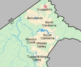
Amaroo is a suburb in the Canberra
, Australia
district of Gungahlin and was gazetted on 18 October 1991. Amaroo – which means ‘a beautiful place’ in one of the local Aboriginal dialects. Place names in Amaroo such as Shoalhaven Avenue are named after Australian rivers and lakes. Amaroo is adjacent to the suburbs of Ngunnawal
, Gungahlin
, Moncrieff
, Forde
, Bonner
and Jacka
. The suburb is bounded by Mirrabei Drive and Horse Park Drive and Gundaroo Drive. The suburb is located approximately 1 km from the Gungahlin Town Centre
and 12 km from the centre of Canberra
.
John and Maria (née Mansfield) Crinigan lived in a stone cottage at this site from about 1842 until 1863. John was a native of Westmeath, Ireland and at 19 years of age was sentenced to transportation for life for “assaulting habitation”. He arrived in the colony of New South Wales
in 1836 and was assigned to work for George Thomas Palmer on his property Palmerville (the remains of the homestead are now under the Heritage Park in Belconnen
).
They settled here in the stone cottage and in 1849 John was pardoned. The site of this cottage was well selected as it is near a pool of water on Ginninderra Creek
.
 The suburb has two schools next to each other, and Good Shepherd Catholic primary. The Amaroo School complex accommodates children from Preschool to Year 10 and is the first purpose-built government Middle School in the ACT. It was completed in three stages.
Its various buildings include the Preschool, the Primary School classroom block, and the two-storey Middle and High School classroom block, together with shared Administration, Library, Hall/Canteen, Gymnasium and outdoor courts and play areas. A combined Technology, Arts and Science block is located within the Middle and High School.
age.
The area was studied in more detail than many other parts of Canberra by J P Ceplecha from the ANU in 1971.
Most of Amaroo is based on slaty shale
and mudstone
.
A 125m wide band oriented north north east of dacite
and quartz andesite
is in the centre. A patch of
tuff
is under the south west corner.
The structure of the rock has been determined by folding. The folds are aligned north-north east and plunge to
the south south west. There are two short faults in the mid south that are marked on the surface by quartz. A
long fault runs parallel with the folding axis along the south east side along Ginninderra Creek determining its orientation.
Canberra
Canberra is the capital city of Australia. With a population of over 345,000, it is Australia's largest inland city and the eighth-largest city overall. The city is located at the northern end of the Australian Capital Territory , south-west of Sydney, and north-east of Melbourne...
, Australia
Australia
Australia , officially the Commonwealth of Australia, is a country in the Southern Hemisphere comprising the mainland of the Australian continent, the island of Tasmania, and numerous smaller islands in the Indian and Pacific Oceans. It is the world's sixth-largest country by total area...
district of Gungahlin and was gazetted on 18 October 1991. Amaroo – which means ‘a beautiful place’ in one of the local Aboriginal dialects. Place names in Amaroo such as Shoalhaven Avenue are named after Australian rivers and lakes. Amaroo is adjacent to the suburbs of Ngunnawal
Ngunnawal, Australian Capital Territory
Ngunnawal is a suburb in the district of Gungahlin in Canberra, Australia. The suburb is named in tribute to the Ngunnawal people, the original inhabitants of the area. The suburb was gazetted on 18 October 1991. Ngunnawal is adjacent to the suburbs of Nicholls, Casey and Amaroo and Taylor...
, Gungahlin
Gungahlin, Australian Capital Territory
Gungahlin is a suburb in the Canberra, Australia district with the same name; Gungahlin. The postcode is 2912. Gungahlin is the name for the entire district, and also the town centre, but it is also the name of the suburb which Gungahlin Town Centre is in....
, Moncrieff
Moncrieff, Australian Capital Territory
Moncrieff is a designated suburb of Gungahlin, Canberra, the National Capital of Australia. The name was gazetted in April 1991 though no official announcement has to be made about the first land release. It is named after Gladys Moncrieff, an Australian singer of the 1920-30s musical era who was...
, Forde
Forde, Australian Capital Territory
Forde is a northern suburb of the Canberra, Australia district of Gungahlin. It is named in honour of Frank Forde, a politician who was Prime Minister of Australia for a week in 1945 following the death of John Curtin. Forde is adjacent to the suburbs of Amaroo, Throsby and Bonner. It is bounded...
, Bonner
Bonner, Australian Capital Territory
Bonner is a planned suburb in the district of Gungahlin in Canberra. The suburb is named in memory after Senator Neville Bonner, Australia's first Indigenous parliamentarian who served the people of Queensland during the years 1971-1984...
and Jacka
Jacka, Australian Capital Territory
Jacka is a designated suburb of Gungahlin, Canberra, the National Capital of Australia. The suburb was gazetted in April 1991 though an official announcement is yet to be made about the first land release...
. The suburb is bounded by Mirrabei Drive and Horse Park Drive and Gundaroo Drive. The suburb is located approximately 1 km from the Gungahlin Town Centre
Gungahlin
Gungahlin is a name of a district and the northernmost town centre of Canberra, Australia. Gungahlin is situated 10 km north of Canberra's city centre and is one of five satellites of Canberra including Woden, Tuggeranong, Weston Creek and Belconnen. Currently Gungahlin comprises 11 suburbs,...
and 12 km from the centre of Canberra
Canberra
Canberra is the capital city of Australia. With a population of over 345,000, it is Australia's largest inland city and the eighth-largest city overall. The city is located at the northern end of the Australian Capital Territory , south-west of Sydney, and north-east of Melbourne...
.
History
Although the suburb of Amaroo is newly established, the history of the land upon which the suburb is situated stretches back at least one hundred and fifty years. Amongst the historic remnants from Amaroo's colonial past is Crinigan’s stone cottage located in Wanderer Court Amaroo.John and Maria (née Mansfield) Crinigan lived in a stone cottage at this site from about 1842 until 1863. John was a native of Westmeath, Ireland and at 19 years of age was sentenced to transportation for life for “assaulting habitation”. He arrived in the colony of New South Wales
New South Wales
New South Wales is a state of :Australia, located in the east of the country. It is bordered by Queensland, Victoria and South Australia to the north, south and west respectively. To the east, the state is bordered by the Tasman Sea, which forms part of the Pacific Ocean. New South Wales...
in 1836 and was assigned to work for George Thomas Palmer on his property Palmerville (the remains of the homestead are now under the Heritage Park in Belconnen
Belconnen
Belconnen is a district of Canberra, the capital city of Australia, comprising 25 suburbs with 29,900 dwellings housing 82,247 people of the 311,518 people in the Australian Capital Territory ....
).
They settled here in the stone cottage and in 1849 John was pardoned. The site of this cottage was well selected as it is near a pool of water on Ginninderra Creek
Ginninderra Creek
Ginninderra Creek is a water course that flows across the Ginninderra Plain through the Gungahlin and Belconnen regions in Canberra, Australia....
.
Community facilities
Its various buildings include the Preschool, the Primary School classroom block, and the two-storey Middle and High School classroom block, together with shared Administration, Library, Hall/Canteen, Gymnasium and outdoor courts and play areas. A combined Technology, Arts and Science block is located within the Middle and High School.
Geology
Amaroo is underlaid by the Canberra Formation from the late middle SilurianSilurian
The Silurian is a geologic period and system that extends from the end of the Ordovician Period, about 443.7 ± 1.5 Mya , to the beginning of the Devonian Period, about 416.0 ± 2.8 Mya . As with other geologic periods, the rock beds that define the period's start and end are well identified, but the...
age.
The area was studied in more detail than many other parts of Canberra by J P Ceplecha from the ANU in 1971.
Most of Amaroo is based on slaty shale
Shale
Shale is a fine-grained, clastic sedimentary rock composed of mud that is a mix of flakes of clay minerals and tiny fragments of other minerals, especially quartz and calcite. The ratio of clay to other minerals is variable. Shale is characterized by breaks along thin laminae or parallel layering...
and mudstone
Mudstone
Mudstone is a fine grained sedimentary rock whose original constituents were clays or muds. Grain size is up to 0.0625 mm with individual grains too small to be distinguished without a microscope. With increased pressure over time the platey clay minerals may become aligned, with the...
.
A 125m wide band oriented north north east of dacite
Dacite
Dacite is an igneous, volcanic rock. It has an aphanitic to porphyritic texture and is intermediate in composition between andesite and rhyolite. The relative proportions of feldspars and quartz in dacite, and in many other volcanic rocks, are illustrated in the QAPF diagram...
and quartz andesite
Andesite
Andesite is an extrusive igneous, volcanic rock, of intermediate composition, with aphanitic to porphyritic texture. In a general sense, it is the intermediate type between basalt and dacite. The mineral assemblage is typically dominated by plagioclase plus pyroxene and/or hornblende. Magnetite,...
is in the centre. A patch of
tuff
Tuff
Tuff is a type of rock consisting of consolidated volcanic ash ejected from vents during a volcanic eruption. Tuff is sometimes called tufa, particularly when used as construction material, although tufa also refers to a quite different rock. Rock that contains greater than 50% tuff is considered...
is under the south west corner.
The structure of the rock has been determined by folding. The folds are aligned north-north east and plunge to
the south south west. There are two short faults in the mid south that are marked on the surface by quartz. A
long fault runs parallel with the folding axis along the south east side along Ginninderra Creek determining its orientation.