
Am Bathach
Encyclopedia
Scotland
Scotland is a country that is part of the United Kingdom. Occupying the northern third of the island of Great Britain, it shares a border with England to the south and is bounded by the North Sea to the east, the Atlantic Ocean to the north and west, and the North Channel and Irish Sea to the...
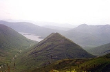
mountain situated at the head of Glen Shiel, at the western end of Loch Cluanie
Loch Cluanie
Loch Cluanie is a loch in the Northwest Highlands of Scotland at the south-east end of Glen Shiel. It is a reservoir, contained behind the Cluanie Dam, constructed by Mitchell Construction and completed in 1957 as part of the North of Scotland Hydro-Electric Board's Glenmoriston project to...
some 38 kilometres south east of Kyle of Lochalsh
Kyle of Lochalsh
Kyle of Lochalsh is a village on the northwest coast of Scotland, 63 miles west of Inverness. It is located at the entrance to Loch Alsh, opposite the village of Kyleakin on the Isle of Skye...
.
Overview
Am Bàthach reaches a height of 798 metres (2618 feet) and is a lone CorbettHill lists in the British Isles
The mountains and hills of Great Britain, and to a lesser extent Ireland, are the subject of a considerable number of lists that categorise them by height, topographic prominence, or other criteria. They are commonly used as a basis for peak bagging, whereby hillwalkers attempt to reach all the...
surrounded by considerably higher Munros, its grassy slopes are in marked contrast to the rockier peaks of the other Glen Shiel hills. it is often climbed along with the adjoining Munro of Ciste Dhubh
Ciste Dhubh
Ciste Dhubh is a mountain situated in the Scottish Highlands between Glen Shiel and Glen Affric. It is a long distance from any centres of population, with Kyle of Lochalsh being almost 30 kilometres away to the west north-west.- Overview :...
with the route over Am Bàthach providing a more interesting and drier route to the Munro than the boggy An Caorann Beag glen. The hill offers an interesting half day walk when ascended on its own and it is frequently the only one of the Kintail mountains in the clear when weather conditions are poor. Am Bàthach’s roof like shape made up of a long NE-SW ridge with steep sides is alleged to resemble a cow shed or a byre and that is the meaning of its translated name, a throwback to the time when cattle where a prominent feature of the Scottish Highlands
Scottish Highlands
The Highlands is an historic region of Scotland. The area is sometimes referred to as the "Scottish Highlands". It was culturally distinguishable from the Lowlands from the later Middle Ages into the modern period, when Lowland Scots replaced Scottish Gaelic throughout most of the Lowlands...
.
Geography
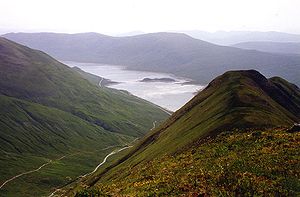
Am Bàthach’s summit ridge is roughly one km in length with the highest point lying at the northern extremity, the southern end of the ridge has a spot height of 734 metres, there is a colMountain pass
A mountain pass is a route through a mountain range or over a ridge. If following the lowest possible route, a pass is locally the highest point on that route...
with a height of 705 metres at the mid point in between the two high points. The steep slopes on either side of the mountain drop down to the valleys of the An Caorann Beag on its west side and the An Caorann Mòr on the eastern flanks, both these hillsides are seamed with numerous small streams. The southern ridge of Am Bàthach descends to the A87 road
A87 road
The A87 is a major road in the Highland region of Scotland.It runs west from its junction with the A82 road at Invergarry , along the north shores of Loch Garry and Loch Cluanie, then down through Glen Shiel and along Loch Duich to Kyle of Lochalsh before crossing the Skye Bridge to Kyleakin,...
as it passes along the northern shore of Loch Cluanie
Loch Cluanie
Loch Cluanie is a loch in the Northwest Highlands of Scotland at the south-east end of Glen Shiel. It is a reservoir, contained behind the Cluanie Dam, constructed by Mitchell Construction and completed in 1957 as part of the North of Scotland Hydro-Electric Board's Glenmoriston project to...
and has been planted with coniferous woodland on its lower slopes, this plantation is an outlying eastern section of the Glenshiel Forest.
The hills northern flank descends by a NW ridge down to the Bealach a’ Chòinich (Pass of the Bog) with a height of 591 metres. The pass, which lives up to its name connects to the two Munros of Ciste Dhubh and Aonach Meadhoin
Aonach Meadhoin
Aonach Meadhoin is a Munro mountain situated in the Kintail region of Scotland. It stands on the northern side of Glen Shiel some 31 kilometres south east of Kyle of Lochalsh.- Overview :...
and has a small lochan lying on it. Am Bàthach is drained by the Allt a’ Chaorainn Bhig and the Allt a’ Chaorainn Mhòir, the two burns which flow down the glens to the east and west of the hill. They flow to Loch Cluanie and reach the east coast of Scotland at the Moray Firth
Moray Firth
The Moray Firth is a roughly triangular inlet of the North Sea, north and east of Inverness, which is in the Highland council area of north of Scotland...
, some 70 km distant, via Glenmoriston
Glenmoriston
Glenmoriston or Glen Moriston is a river glen in the Scottish Highlands, that runs from Loch Ness, at the village of Invermoriston, westwards to Loch Cluanie, where it meets with Glen Shiel. The A887 and A87 roads pass through Glenmoriston....
and Loch Ness
Loch Ness
Loch Ness is a large, deep, freshwater loch in the Scottish Highlands extending for approximately southwest of Inverness. Its surface is above sea level. Loch Ness is best known for the alleged sightings of the cryptozoological Loch Ness Monster, also known affectionately as "Nessie"...
.