

Alblasserwaard
Encyclopedia
The Alblasserwaard is a polder
in the province South Holland
in the Netherlands
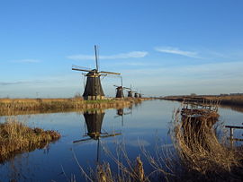
. It is mainly known for the windmills of Kinderdijk
, a village in the northwest of the Alblasserwaard.
 The first human inhabitants of the Alblasserwaard settled there after the last Ice Age
, around 10.000 years ago. The ice had not reached the area itself, but eolian deposits created high points in the wet environment. These high points were places where hunter-gatherer
s settled, as archaeological investigations in the area have shown.
During the Middle Ages
several canals and dikes were created to reclaim the land, with the last part being endiked in the second half of the 14th century. Yet numerous floods continued to happen throughout the history of the area, as it is bound by rivers on all sides.
During World War II
the Bombing of Rotterdam also damaged the Alblasserwaard, when both the village center of Alblasserdam
and a part of Papendrecht
were hit by German bombs.
, to the west runs the Noord
and to the south the river Merwede
. On the east side are the Merwede-Kanaal, the Linge
and the Zederik
, together forming the boundary with Vijfheerenlanden. De village Kinderdijk, well-known from its windmills, is located at the northwest corner of the Alblasserwaard, where the Noord and the Lek joins.
Most of the Alblasserwaard is rural, but partially under the influence of the cities Rotterdam
and Dordrecht
on the borders of the area, the south and west are urbanized.
The largest cities in the Alblasserwaard are Gorinchem
, with 35,000 inhabitants, and Papendrecht
with slightly over 30,000 people. Both are on the southern borders of the Alblasserwaard. The other municipalities in the Alblasserwaard are:
 Extensive parts of the Netherlands are below sea level, and the Alblasserwaard is no different. Most of it has been won from the water through land reclamation
, using the windmills on the Kinderdijk. This process led to the area being full of dikes alongside the rivers. Most of the Alblasserwaard is grassland, where in the spring and summer one will find herds of cows, sheep and goats. The ground consists of clay.
Polder
A polder is a low-lying tract of land enclosed by embankments known as dikes, that forms an artificial hydrological entity, meaning it has no connection with outside water other than through manually-operated devices...
in the province South Holland
South Holland
South Holland is a province situated on the North Sea in the western part of the Netherlands. The provincial capital is The Hague and its largest city is Rotterdam.South Holland is one of the most densely populated and industrialised areas in the world...
in the Netherlands
Netherlands
The Netherlands is a constituent country of the Kingdom of the Netherlands, located mainly in North-West Europe and with several islands in the Caribbean. Mainland Netherlands borders the North Sea to the north and west, Belgium to the south, and Germany to the east, and shares maritime borders...
. It is mainly known for the windmills of Kinderdijk
Kinderdijk
Kinderdijk is a village in the Netherlands, belonging to the municipality of Nieuw-Lekkerland, in the province South Holland, about 15 km east of Rotterdam. Kinderdijk is situated in a polder at the confluence of the Lek and Noord rivers. To drain the polder, a system of 19 windmills was built...
, a village in the northwest of the Alblasserwaard.
History
Ice age
An ice age or, more precisely, glacial age, is a generic geological period of long-term reduction in the temperature of the Earth's surface and atmosphere, resulting in the presence or expansion of continental ice sheets, polar ice sheets and alpine glaciers...
, around 10.000 years ago. The ice had not reached the area itself, but eolian deposits created high points in the wet environment. These high points were places where hunter-gatherer
Hunter-gatherer
A hunter-gatherer or forage society is one in which most or all food is obtained from wild plants and animals, in contrast to agricultural societies which rely mainly on domesticated species. Hunting and gathering was the ancestral subsistence mode of Homo, and all modern humans were...
s settled, as archaeological investigations in the area have shown.
During the Middle Ages
Middle Ages
The Middle Ages is a periodization of European history from the 5th century to the 15th century. The Middle Ages follows the fall of the Western Roman Empire in 476 and precedes the Early Modern Era. It is the middle period of a three-period division of Western history: Classic, Medieval and Modern...
several canals and dikes were created to reclaim the land, with the last part being endiked in the second half of the 14th century. Yet numerous floods continued to happen throughout the history of the area, as it is bound by rivers on all sides.
During World War II
World War II
World War II, or the Second World War , was a global conflict lasting from 1939 to 1945, involving most of the world's nations—including all of the great powers—eventually forming two opposing military alliances: the Allies and the Axis...
the Bombing of Rotterdam also damaged the Alblasserwaard, when both the village center of Alblasserdam
Alblasserdam
Alblasserdam is a town in the western Netherlands, in the province of South Holland. The municipality covers an area of , of which is water. Alblasserdam is officially a part of the Drechtsteden...
and a part of Papendrecht
Papendrecht
Papendrecht is a town and municipality in the western Netherlands, in the province of South Holland, at the crossing of the River Beneden Merwede and the Noord River...
were hit by German bombs.
Geography and Population
The Alblasserwaard is bordered by rivers on all sides. To the north is the LekLek River
The Lek is a river in the western Netherlands of some 60 km in length. It is the continuation of the Nederrijn after the Kromme Rijn branches off at the town of Wijk bij Duurstede. The main westbound waterway is hereafter called the Lek River...
, to the west runs the Noord
Noord (river)
The Noord is a short tidal river in South Holland, Netherlands.It starts at the city of Dordrecht where the Beneden Merwede river forks into the Oude Maas and the Noord. It joins the Lek at the city of Ridderkerk and Kinderdijk, and the combined stream is thereafter known as the Nieuwe Maas. The...
and to the south the river Merwede
Merwede
The Merwede is the name of several interconnected stretches of river in The Netherlands, all part of the Rhine-Meuse-Scheldt delta. The Meuse river joins the Waal at Woudrichem to form the Boven Merwede...
. On the east side are the Merwede-Kanaal, the Linge
Linge
Linge is a river in the Betuwe that is over 100 km long, which makes it one of the longest rivers that flow entirely within the Netherlands.It starts near the village Doornenburg near the German border. A legend tells us that if there will be no more pigs grazing at the castle of Doornenburg, the...
and the Zederik
Zederik
Zederik is a municipality in the western Netherlands, in the province of South Holland. The municipality covers an area of 76.49 km²...
, together forming the boundary with Vijfheerenlanden. De village Kinderdijk, well-known from its windmills, is located at the northwest corner of the Alblasserwaard, where the Noord and the Lek joins.
Most of the Alblasserwaard is rural, but partially under the influence of the cities Rotterdam
Rotterdam
Rotterdam is the second-largest city in the Netherlands and one of the largest ports in the world. Starting as a dam on the Rotte river, Rotterdam has grown into a major international commercial centre...
and Dordrecht
Dordrecht
Dordrecht , colloquially Dordt, historically in English named Dort, is a city and municipality in the western Netherlands, located in the province of South Holland. It is the fourth largest city of the province, having a population of 118,601 in 2009...
on the borders of the area, the south and west are urbanized.
The largest cities in the Alblasserwaard are Gorinchem
Gorinchem
Gorinchem , also called Gorkum , is a city and municipality in the western Netherlands, in the province of South Holland. The municipality covers an area of 21.99 km² of which 3.03 km² is water...
, with 35,000 inhabitants, and Papendrecht
Papendrecht
Papendrecht is a town and municipality in the western Netherlands, in the province of South Holland, at the crossing of the River Beneden Merwede and the Noord River...
with slightly over 30,000 people. Both are on the southern borders of the Alblasserwaard. The other municipalities in the Alblasserwaard are:
- AlblasserdamAlblasserdamAlblasserdam is a town in the western Netherlands, in the province of South Holland. The municipality covers an area of , of which is water. Alblasserdam is officially a part of the Drechtsteden...
- GiessenlandenGiessenlandenGiessenlanden is a municipality in the western Netherlands, in the province of South Holland. The municipality covers an area of 65.12 km² of which 1.55 km² is water....
- GraafstroomGraafstroomGraafstroom is a municipality in the western Netherlands, in the province of South Holland. The municipality had a population of 9,697 in 2004, and covers an area of 69.32 km² of which 2.21 km² is water....
- Hardinxveld-GiessendamHardinxveld-GiessendamHardinxveld-Giessendam is a municipality in the western Netherlands, in the province of South Holland. The municipality had a population of 17,828 in 2004, and covers an area of 19.35 km² of which 2.44 km² is water....
- LiesveldLiesveldLiesveld is a municipality in the western Netherlands, in the province of South Holland. The municipality had a population of 9,810 in 2006, and covers an area of 44.44 km² of which 3.37 km² is water....
- Nieuw-LekkerlandNieuw-LekkerlandNieuw-Lekkerland is a town and municipality in the western Netherlands, in the province of South Holland. It is situated on the southern shores of the Lek River, in the north-western part of the Alblasserwaard...
- SliedrechtSliedrechtSliedrecht is a town and municipality in the western Netherlands, in the province of South Holland. The municipality covers an area of ....
- ZederikZederikZederik is a municipality in the western Netherlands, in the province of South Holland. The municipality covers an area of 76.49 km²...
Geology
Land reclamation
Land reclamation, usually known as reclamation, is the process to create new land from sea or riverbeds. The land reclaimed is known as reclamation ground or landfill.- Habitation :...
, using the windmills on the Kinderdijk. This process led to the area being full of dikes alongside the rivers. Most of the Alblasserwaard is grassland, where in the spring and summer one will find herds of cows, sheep and goats. The ground consists of clay.
Nature and Recreation
While large parts of the Alblasserwaard are owned by farmers, or are populated, some areas are open to the public for recreation.- The windmills of Kinderdijk are a major tourist attraction.
- In the southwest of the Alblasserwaard is the Alblasserbos, an artificial forest area where deer and foxes live, as well as numerous smaller species.
- Roughly between Streefkerk and BrandwijkBrandwijkBrandwijk is a small village in the Dutch province of South Holland. It is a part of the municipality of Graafstroom, and lies about 13 km west of Gorinchem....
is the area Donkse LaagtenDonkse LaagtenThe Donkse Laagten is a small Dutch nature reserve of roughly two square kilometres in the Alblasserwaard in the province of South Holland. It is located between the towns Streefkerk to the northwest and Bleskensgraaf to the south. The area is governed by the organization Staatsbosbeheer...
, which is under the protection of the Dutch governmental branch StaatsbosbeheerStaatsbosbeheerStaatsbosbeheer is a Dutch organization founded in 1899 to control and conserve Dutch nature reserves.Staatsbosbeheer currently oversees over 250.000 hectares of land in the Netherlands. Usually this land is open to the public for recreational purposes, but restrictions often apply...
. - There are three free camping spots in the Alblasserwaard, as part of a project by Staatsbosbeheer to promote legal camping in the wild. These are located respectively in the Alblasserbos, the Donkse Laagten and the Avelingen.
- The Lammetjeswiel is a recreational area within the village of Alblasserdam. It is a popular swimming area, with governmental checks of the water condition twice a month.
External links
- Google Map of the Alblasserwaard
- UNESCO about the windmills at Kinderdijk (World Heritage List)
- UNESCO about the eastern Alblasserwaard (Tentative List)