

Alaskan Way
Encyclopedia
Alaskan Way, originally Railroad Avenue, is a street in Seattle, Washington, that runs along the Elliott Bay
waterfront from just north of S. Holgate Street in the Industrial District
—south of which it becomes East Marginal Way S.— to Broad Street in Belltown
—north of which is Myrtle Edwards Park
and the Olympic Sculpture Park
. The right-of-way continues northwest through the park, just west of the BNSF Railway
mainline, and the roadway picks up again for a few blocks at Smith Cove
. It follows a route known in the late 19th century as the "Ram's Horn" (because of its shape). Alaskan Way gives its name to the Alaskan Way Viaduct
, which carries Washington State Route 99
through Downtown Seattle
.
 The idea of building a rail corridor along Seattle's Central Waterfront goes back at least to Thomas Burke and Daniel Hunt Gilman
and the construction of the Seattle, Lake Shore and Eastern Railway
in the years before the Great Seattle Fire
of 1889. Railroad Avenue was built as a planked roadway on pilings over the waters of Elliott Bay. South of Downtown, the rail line constituted the one major man-made feature in an area of tideflats.
The portion of Railroad Avenue from Yesler Way in what is now the Pioneer Square
neighborhood to University Street near today's Harbor Steps burned in the Great Fire, as did most of the city and most of its piers. All were soon rebuilt on a grander scale. In the case of Railroad Avenue, this was largely the work of the Northern Pacific Railroad and Great Northern Railway. The tideflats were steadily filled in, placing the rails south of Downtown—and the route of the southern portion of today's Alaskan Way—on dry land.
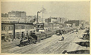
Around 1900, Railroad Avenue was a chaos of horses and buggies, pedestrians, and rail cars, with multiple railroad tracks and sidings. The congestion of the rail corridor was somewhat relieved when the Great Northern built a rail tunnel (1903–1906) under Downtown. From that time, only traffic that actually needed to access the waterfront had to use Railroad Avenue; other trains could bypass the busy corridor. Still, there continued to be problems with the structural integrity of the planked roadway. Pilings had been driven into soft tideland substrates, waves caused continual damage, and railroad freight cars continually stressed the structure. Between 1911 and 1916, a concrete seawall
strengthened the portion of the waterfront between S. Washington Street and Madison Street.
Federal funds supplemented a local levy to allow the city to extend the seawall northward to Bay Street. The project was completed in 1936, and the extent of the seawall is the same as of 2008. Railroad Avenue was replaced by Alaskan Way, along the same route but built on landfill
rather than on pilings. In the early 1950s, the Alaskan Way Viaduct was built, paralleling Alaskan Way for much of its distance.
Elliott Bay
Elliott Bay is the body of water on which Seattle, Washington, is located. A line drawn from Alki Point in the south to West Point in the north serves to mark the generally accepted division between the bay and the open sound...
waterfront from just north of S. Holgate Street in the Industrial District
Industrial District, Seattle, Washington
The Industrial District is the principal industrial area of Seattle, Washington. It is bounded on the west by the Duwamish Waterway and Elliott Bay, beyond which lies Delridge of West Seattle; on the east by Interstate 5, beyond which lies Beacon Hill; on the north by S King and S Dearborn Streets,...
—south of which it becomes East Marginal Way S.— to Broad Street in Belltown
Belltown, Seattle, Washington
Belltown is a neighborhood in Seattle, Washington, United States, in the 98121 Zip Code, located on the city's downtown waterfront, on land that was artificially flattened as part of a regrading project...
—north of which is Myrtle Edwards Park
Myrtle Edwards Park
Myrtle Edwards Park in Seattle, Washington is a 4.8 acre public park along the Elliott Bay waterfront north of Belltown. It features a 1.25-mile long bicycle and walking path and is a good place to see eagles, gulls, and crows....
and the Olympic Sculpture Park
Olympic Sculpture Park
The Olympic Sculpture Park is a public park in Seattle, Washington that opened on January 20, 2007.The park consists of a outdoor sculpture museum and beach. The park was designed by Weiss/Manfredi Architects, along with Charles Anderson Landscape Architecture and other consultants. It is...
. The right-of-way continues northwest through the park, just west of the BNSF Railway
BNSF Railway
The BNSF Railway is a wholly owned subsidiary of Berkshire Hathaway Inc., and is headquartered in Fort Worth, Texas. It is one of seven North American Class I railroads and the second largest freight railroad network in North America, second only to the Union Pacific Railroad, its primary...
mainline, and the roadway picks up again for a few blocks at Smith Cove
Smith Cove (Washington)
Smith Cove is a body of water, the northern part of Seattle, Washington's Elliott Bay, immediately south of the area that has been known since 1894 as Interbay...
. It follows a route known in the late 19th century as the "Ram's Horn" (because of its shape). Alaskan Way gives its name to the Alaskan Way Viaduct
Alaskan Way Viaduct
The Alaskan Way Viaduct, completed on April 4, 1953, is a double-decked elevated section of State Route 99 that runs along the Elliott Bay waterfront in Seattle's Industrial District and downtown Seattle. It is the smaller of the two major north–south traffic corridors through Seattle ,...
, which carries Washington State Route 99
Washington State Route 99
State Route 99, abbreviated SR 99, commonly called Highway 99, is a numbered state highway in the U.S. state of Washington extending just under from Fife in the south to Everett in the north, with a gap in Tukwila.-Southern division:...
through Downtown Seattle
Downtown Seattle
Downtown is the central business district of Seattle, Washington. It is fairly compact compared to other city centers on the West Coast because of its geographical situation: hemmed in on the north and east by hills, on the west by the Elliott Bay, and on the south by reclaimed land that was once...
.
History
Daniel Hunt Gilman
Daniel Hunt Gilman was an American attorney and railroad builder who made his career in Seattle.-Early life:Gilman was born in Levant, Maine, the son of Maine legislator Henry Gilman and his wife Mary Gilman...
and the construction of the Seattle, Lake Shore and Eastern Railway
Seattle, Lake Shore and Eastern Railway
The Seattle, Lake Shore and Eastern Railway was a railroad founded in Seattle, Washington, on April 28, 1885, with three tiers of purposes: Build and run the initial line to the town of Ballard, bring immediate results and returns to investors; exploit resources east in the valleys, foothills,...
in the years before the Great Seattle Fire
Great Seattle Fire
The Great Seattle Fire was a fire that destroyed the entire central business district of Seattle, Washington, USA, on June 6, 1889.-Early Seattle:In the fall of 1851, the Denny Party arrived at Alki Point in what is now the state of Washington...
of 1889. Railroad Avenue was built as a planked roadway on pilings over the waters of Elliott Bay. South of Downtown, the rail line constituted the one major man-made feature in an area of tideflats.
The portion of Railroad Avenue from Yesler Way in what is now the Pioneer Square
Pioneer Square, Seattle, Washington
Pioneer Square is a neighborhood in the southwest corner of Downtown Seattle, Washington, USA. It was once the heart of the city: Seattle's founders settled there in 1852, following a brief six-month settlement at Alki Point on the far side of Elliott Bay. The early structures in the neighborhood...
neighborhood to University Street near today's Harbor Steps burned in the Great Fire, as did most of the city and most of its piers. All were soon rebuilt on a grander scale. In the case of Railroad Avenue, this was largely the work of the Northern Pacific Railroad and Great Northern Railway. The tideflats were steadily filled in, placing the rails south of Downtown—and the route of the southern portion of today's Alaskan Way—on dry land.
Around 1900, Railroad Avenue was a chaos of horses and buggies, pedestrians, and rail cars, with multiple railroad tracks and sidings. The congestion of the rail corridor was somewhat relieved when the Great Northern built a rail tunnel (1903–1906) under Downtown. From that time, only traffic that actually needed to access the waterfront had to use Railroad Avenue; other trains could bypass the busy corridor. Still, there continued to be problems with the structural integrity of the planked roadway. Pilings had been driven into soft tideland substrates, waves caused continual damage, and railroad freight cars continually stressed the structure. Between 1911 and 1916, a concrete seawall
Seawall
A seawall is a form of coastal defence constructed where the sea, and associated coastal processes, impact directly upon the landforms of the coast. The purpose of a seawall is to protect areas of human habitation, conservation and leisure activities from the action of tides and waves...
strengthened the portion of the waterfront between S. Washington Street and Madison Street.
Federal funds supplemented a local levy to allow the city to extend the seawall northward to Bay Street. The project was completed in 1936, and the extent of the seawall is the same as of 2008. Railroad Avenue was replaced by Alaskan Way, along the same route but built on landfill
Landfill
A landfill site , is a site for the disposal of waste materials by burial and is the oldest form of waste treatment...
rather than on pilings. In the early 1950s, the Alaskan Way Viaduct was built, paralleling Alaskan Way for much of its distance.