

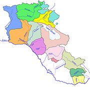
Aghstafa River
Encyclopedia
Armenia
Armenia , officially the Republic of Armenia , is a landlocked mountainous country in the Caucasus region of Eurasia...
and Azerbaijan
Azerbaijan
Azerbaijan , officially the Republic of Azerbaijan is the largest country in the Caucasus region of Eurasia. Located at the crossroads of Western Asia and Eastern Europe, it is bounded by the Caspian Sea to the east, Russia to the north, Georgia to the northwest, Armenia to the west, and Iran to...
, and is a right tributary
Tributary
A tributary or affluent is a stream or river that flows into a main stem river or a lake. A tributary does not flow directly into a sea or ocean...
of the Kura River
Kura River
Kura is a river, also known from the Greek as the Cyrus in the Caucasus Mountains. Starting in north-eastern Turkey, it flows through Turkey to Georgia, then to Azerbaijan, where it receives the Aras River as a right tributary, and enters the Caspian Sea...
.
Aghstafa has a length of 133 km, and a basin area of 2589 km². Along the river lie the cities of Dilijan
Dilijan
Dilijan is a spa town in Armenia, located in the northern Armenian province of Tavush. It is one of the most important resorts of Armenia, situated in Dilijan National Park. The forested and reclusive city is home to numerous Armenian artists, composers, and filmmakers and features some...
, Ijevan
Ijevan
Ijevan now is a city in Armenia and the capital of Tavush region. It is located in the northern part of the region, on the foot of Ijevan ridge and Nal'teket ridge on both banks of Aghstev River. The city's current name, Ijevan, and its former name Karavansara both mean "inn" , in Armenian and...
, Gazakh and Aghstafa
Agstafa
-Overview:Agstafa raion was created on 24 January 1939 as an independent administrative unit out of larger Qazakh region of Azerbaijan. On 4 December 1959, the status of the raion was abolished and it was incorporated into Qazakh Rayon...
.
See also
- Rivers and lakes in ArmeniaRivers and lakes in ArmeniaThe Rivers and lakes in Armenia are mainly powered by fresh water. Throughout history Armenia has been called Nairi by the Assyrians meaning the "Land of the lakes and rivers". The Armenia is home to many rivers and lakes....
- Rivers and lakes in AzerbaijanRivers and lakes in AzerbaijanThe water bodies of Azerbaijan were formed over a long geological timeframe and changed significantly throughout that period. This is particularly evidenced by remnants of ancient rivers found throughout the country. The country's water systems are continually changing under the influence of...
- Geography of ArmeniaGeography of ArmeniaArmenia is a landlocked country in the South Caucasus region, between the Black and Caspian Seas, bordered on the north and east by Georgia and Azerbaijan and on the south and west by Iran and Turkey....
- Geography of AzerbaijanGeography of AzerbaijanAzerbaijan is situated in the Caucasus region of Eurasia. Three physical features dominate Azerbaijan: the Caspian Sea, whose shoreline forms a natural boundary to the east; the Greater Caucasus mountain range to the north; and the extensive flatlands at the country's center...