

Rivers and lakes in Azerbaijan
Encyclopedia
Azerbaijan
Azerbaijan , officially the Republic of Azerbaijan is the largest country in the Caucasus region of Eurasia. Located at the crossroads of Western Asia and Eastern Europe, it is bounded by the Caspian Sea to the east, Russia to the north, Georgia to the northwest, Armenia to the west, and Iran to...
were formed over a long geological timeframe and changed significantly throughout that period. This is particularly evidenced by remnants of ancient rivers found throughout the country. The country's water systems are continually changing under the influence of natural forces and human introduced industrial activities. Artificial rivers (canals) and pond
Pond
A pond is a body of standing water, either natural or man-made, that is usually smaller than a lake. A wide variety of man-made bodies of water are classified as ponds, including water gardens, water features and koi ponds; all designed for aesthetic ornamentation as landscape or architectural...
s are a part of Azerbaijan's water systems.
The hydrography
Hydrography
Hydrography is the measurement of the depths, the tides and currents of a body of water and establishment of the sea, river or lake bed topography and morphology. Normally and historically for the purpose of charting a body of water for the safe navigation of shipping...
of Azerbaijan basically belongs to the Caspian Sea basin.
Rivers
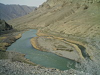
Rivers form the principal part of the water systems of Azerbaijan. There are 8,359 rivers of various lengths within Azerbaijan. Of them 8,188 rivers are less than 25 kilometers in length. Only 24 rivers are over 100 kilometers long. The largest rivers that flow through the country are:- KurKura RiverKura is a river, also known from the Greek as the Cyrus in the Caucasus Mountains. Starting in north-eastern Turkey, it flows through Turkey to Georgia, then to Azerbaijan, where it receives the Aras River as a right tributary, and enters the Caspian Sea...
- Araz
- Ganikh, located in Alazan
- Qabirri also known as Iori
- Samur
- PirsaatPirsaat RiverThe Pirsaat River is a river in Azerbaijan which flows through Ismailli, Shamakhi and Salyan Rayons. Length - 199 km, basin area - 2,280 km2. The river is fed with snow, rain and groundwater. Its largest tributary is Zoghalava....
- Tartarchay (tributaries LevçayLevçayLevçay is one of the tributaries of the Tartarchay located in Karabakh of Republic of Azerbaijan.-Overview:Levçay is the left tributary of Tartarchay, a long river flowing from mountains in central Kalbajar Rayon into...
, AğdabançayAğdabançayAğdabançay is one of the tributaries of the Tartarchay located in Karabakh region of Republic of Azerbaijan.-Overview:Ağdabançay is the left tributary of Tartarchay, a long river flowing from an altitude of in central Kalbajar Rayon into Tartarchay which then proceeds west through Tartar and...
, TurağayçayTurağayçayTurağayçay is one of the tributaries of Tartarchay located in Karabakh region of Azerbaijan.-Overview:Ağdabançay is the right tributary of Tartarchay, a long river flowing from an altitude of in eastern Tartar Rayon into Tartarchay at an altitude of which then proceeds west through Tartar and...
) - TuryanTuryanTuryan , also called Turyanchay is a river of Azerbaijan. It flows through Qabala and Goychay raions.-Overview:Turyanchay starts off at Ragdan Peak which is located on the boundary of Qabala and Oguz raions, in Saral range at 3,680 meters above sea level...
- AgstafaAghstafa RiverAghstafa is a river in Armenia and Azerbaijan, and is a right tributary of the Kura River.Aghstafa has a length of 133 km, and a basin area of 2589 km². Along the river lie the cities of Dilijan, Ijevan, Gazakh and Aghstafa.-See also:...
- Hekeri
- VileshVileshVilesh also called Vileshchay is a river of Azerbaijan. It is one of the largest rivers of the country flowing into the Caspian Sea in southeastern Azerbaijan.-Overview:...
River system
The rivers in Azerbaijan can be divided into three groups:- The Kur basin rivers (Qanix, Qabirri, Turyan, Agstafa, Shekir, Terter, Khachin, etc.)
- The Araz basin rivers (Arpachay, Nakhchivan, Okhchu, Hekeri, Kondelenchay, etc.)
- Rivers, flowing directly into the Caspian Sea (Samur, Gudyal, Velvele, Vilesh, Lenkeran, etc.)
Azerbaijan river systems are changing and evolving under the influence of various physiographic factors: climate, landscape, geological structure, soil and vegetation.
The density of the river network increases, then gradually decreases later with higher altitudes. Except for the Talysh region (1.6-2.2 km/km²), the river system density is the highest (1-2 km/km²) at 1,000-2,500 kilometers, while in the area of the Talysh mountains it peaks at 1.6-2.2 km/km² at 500-1,000 km. The average density of the river system of Azerbaijan is 0.39 km/km². The density is even lower than 0.05 km/km² in the plains.
Kura and Aras
The Kura and Aras are the most popular rivers in Azerbaijan, they run through the Kura-Aras LowlandKura-Aras Lowland
The Kura-Aras Lowland, Kura-Aras Depression or Kura-Aras Basin is a vast depression in central-southern Azerbaijan defined by the valleys of the Kura River and Aras River. It is situated by the West shore of the Caspian Sea and is part of the Aral-Caspian Depression...
. The rivers that directly flow into the Caspian Sea, originate mainly from the north-eastern slope of the Greater Caucasus
Greater Caucasus
Greater Caucasus , sometimes translated as "Caucasus Major", "Big Caucasus" or "Large Caucasus") is the major mountain range of the Caucasus Mountains....
and Talysh Mountains
Talysh Mountains
Talysh Mountains is a mountain chain in northwestern Iran, and southeastern Republic of Azerbaijan in the northwest section of the Elburz Mountains, extending southeastward from the Lankaran Lowland in southeast Azerbaijan to the lower part of the Sefid Rud in northwest Iran...
and run along the Samur-Devechi and Lenkeran lowlands.
The Kura River basin area (86,000 km²) up to the junction with the Aras River is smaller than the Aras water basin (101,937 km²). The river is still called Kura on the junction because the water level of the Kura is twice as high as that of the Aras River.
Lakes
- JandargolJandargolJandargol is a lake of Azerbaijan....
- Lake Hadjikabul - the largest lake of the Azerbaijan (after the Caspian SeaCaspian SeaThe Caspian Sea is the largest enclosed body of water on Earth by area, variously classed as the world's largest lake or a full-fledged sea. The sea has a surface area of and a volume of...
) - Lake BoyukshorLake BoyukshorBoyukshor , also spelled separately Boyuk Shor is the second largest lake of Azerbaijan and largest on Absheron Peninsula...
- Lake SarysuLake SarysuSarysu is a relatively large lake of Azerbaijan located in Imishli and Sabirabad raions of the Kur-Araz Lowland.-Overview:Sarysu lake stretches along the Kura River from Imishli Rayon southeast to Sabirabad Rayon reaching the total length of . It is one of the four lakes present in the area and is...
- Lake GoygolLake GoygolGöygöl is a natural impounded lake in Azerbaijan. It is situated at the footsteps of Murovdag, not far from Ganja.-History:Due to an earthquake which hit the area on 25 September 1139, parts of the Kapaz Mount collapsed and blocked the path of the Kürəkçay River...
- Nohur
- Maral-golMaral-golMaral-gol is a lake of Azerbaijan....
- MasazirgolMasazirgolMasazirgol , or Masazir Lake is a salty lake of in Qaradag raion, near Baku, Azerbaijan.The overall area of the lake is 10 km2.Large volumes of chloride and sulphate are concentrated in ion composition of the water. A new salt making plant was built in 2010 for production of 2 Azeri brands of salt....
- AjinohurAjinohurAjinohur is a lake of Azerbaijan....
- Boyuk AlagolBoyuk AlagolBoyuk Alagol is a lake of Azerbaijan. It's located Karabakh volcanic plateau, in Kalbajar Rayon. Since 1993, it's under occupation by Armenian forces. Its area is 5.1 km2 and the volume of water reaches 24.3 m3.-External links:*...
Reservoirs
Over 60 water reservoirs have been constructed in order to regulate the river flow in Azerbaijan. The formation of these reservoirs is one of the measures that has been undertaken in order to ration the utilization of water and energy resources. The largest water reservoirs are:- Mingachevir reservoirMingachevir reservoirThe Mingachevir reservoir is a large lake in northwestern Azerbaijan. It is the largest reservoir in the Caucasus.-Overview:The reservoir was built on a section of Kura River flowing through Mount Bozdağ in 1953. The filling capacity of the reservoir is whereas the volume is 15730 mln m³...
- Shemkir reservoirShemkir reservoirThe Shamkir reservoir is a large lake in the Shamkir Rayon of northwestern Azerbaijan. It is thesecond largest reservoir in the Caucasus after the Mingachevir reservoir.- Overview :...
- Araz reservoir
- Serseng reservoirSarsang reservoirThe Sarsang reservoir is a large lake located de-jure in Tartar Rayon of Azerbaijan and de-facto in Martakert Province of Nagorno-Karabakh Republic, formed by a hydroelectric dam. It is one of Azerbaijan's 61 water reservoirs, however Azerbaijan does not control the territory it is located...
- Agstafachay reservoirAgstafachay reservoirThe Agstafachay reservoir is a large lake in the Agstafa Rayon of northwestern Azerbaijan.- Overview :The Agstafachay reservoir was built on Agstafa River in 1969 near the village of Cəfərli of Qazakh Rayon. The area of the Agstafa reservoir is . The overall volume of the reservoir is 120 million m3...
- Varvara reservoirVarvara reservoir- Overview :Varvara reservoir is located south from Mingachevir reservoir. It was built in 1952 to manage the water flow ofthe daily outflow of water from Mingachevir reservoir discharging into Kura river, in order to produce electricity. The overall area is and the reservoir volume is . The...
- Jeyranbatan reservoirJeyranbatan reservoirJeyranbatan reservoir is an artificial lake in the Absheron Rayon in eastern part of Azerbaijan. It is located between Baku and Sumgayit cities, next to Ceyranbatan settlement 20 km away from Baku...
- Khanbulanchay reservoirKhanbulanchay reservoirKhanbulanchay reservoir , also known as Khanbulaqchay reservoir, is a lake in Lankaran Rayon of southeastern Azerbaijan. The name means "the spring of the khan" in Azerbaijani language.-Overview:...
- Yenikend reservoirYenikend reservoirThe Yenikend reservoir is a large lake in the Shamkir Rayon of northwestern Azerbaijan. It is the third largest reservoir in the Caucasus after the Mingachevir and Shamkir reservoirs.-Overview:...
The reservoirs in Azerbaijan are designed to be utilized for various purposes, while most other ponds are used exclusively for irrigation.
See also
- Nature of AzerbaijanNature of AzerbaijanThe environment of Azerbaijan includes a wide diversity of climates, animals, plants, and habitats.-National protection:Due to the tapping of oil reserves in the early 20th century, Azerbaijan has had sufficient resources to develop an industrial sector, which in turn led to a significant increase...
- Caspian Sea and Azerbaijan
External links
- Rivers of Azerbaijan (in AzerbaijaniAzerbaijani languageAzerbaijani or Azeri or Torki is a language belonging to the Turkic language family, spoken in southwestern Asia by the Azerbaijani people, primarily in Azerbaijan and northwestern Iran...
)