

Geography of Armenia
Encyclopedia
Armenia
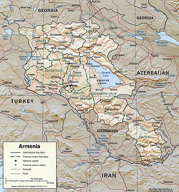
Armenia , officially the Republic of Armenia , is a landlocked mountainous country in the Caucasus region of Eurasia...
is a landlocked country in the South Caucasus region, between the Black
Black Sea
The Black Sea is bounded by Europe, Anatolia and the Caucasus and is ultimately connected to the Atlantic Ocean via the Mediterranean and the Aegean seas and various straits. The Bosphorus strait connects it to the Sea of Marmara, and the strait of the Dardanelles connects that sea to the Aegean...
and Caspian Sea
Caspian Sea
The Caspian Sea is the largest enclosed body of water on Earth by area, variously classed as the world's largest lake or a full-fledged sea. The sea has a surface area of and a volume of...
s, bordered on the north and east by Georgia
Georgia (country)
Georgia is a sovereign state in the Caucasus region of Eurasia. Located at the crossroads of Western Asia and Eastern Europe, it is bounded to the west by the Black Sea, to the north by Russia, to the southwest by Turkey, to the south by Armenia, and to the southeast by Azerbaijan. The capital of...
and Azerbaijan
Azerbaijan
Azerbaijan , officially the Republic of Azerbaijan is the largest country in the Caucasus region of Eurasia. Located at the crossroads of Western Asia and Eastern Europe, it is bounded by the Caspian Sea to the east, Russia to the north, Georgia to the northwest, Armenia to the west, and Iran to...
and on the south and west by Iran
Iran
Iran , officially the Islamic Republic of Iran , is a country in Southern and Western Asia. The name "Iran" has been in use natively since the Sassanian era and came into use internationally in 1935, before which the country was known to the Western world as Persia...
and Turkey
Turkey
Turkey , known officially as the Republic of Turkey , is a Eurasian country located in Western Asia and in East Thrace in Southeastern Europe...
.
The terrain is mostly mountainous and flat, with fast flowing rivers and few forests but with many trees. The climate is highland continental: hot summers and cold winters. The land rises to 4,095 m above sea-level at Mount Aragats
Mount Aragats
Mount Aragats , Alagoz - is a large andesitic-to-dacitic stratovolcano in NW Armenia about 40 km NW of the capital city of Yerevan. It is the highest point in Armenia, located in the province of Aragatsotn, northwest from Yerevan. Located on its slopes are the Byurakan Observatory and the...
.
Pollution from toxic chemicals such as DDT
DDT
DDT is one of the most well-known synthetic insecticides. It is a chemical with a long, unique, and controversial history....
is not helping the already poor soil quality in many parts of the country.
Armenia is trying to address its environmental problems. It has established a Ministry of Nature Protection and introduced taxes for air and water pollution and solid waste disposal, whose revenues are used for environmental protection activities. Armenia is interested in cooperating with other members of the Commonwealth of Independent States (CIS, a group of 12 former Soviet republics) and with members of the international community on environmental issues. The Armenian Government is working toward closing the Armenian Nuclear Power Plant as soon as alternative energy sources are identified.
Geographic coordinates: 40°00′N 45°00′E
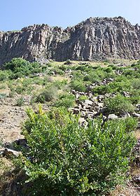
Physical environment
Russia
Russia or , officially known as both Russia and the Russian Federation , is a country in northern Eurasia. It is a federal semi-presidential republic, comprising 83 federal subjects...
between the Black Sea
Black Sea
The Black Sea is bounded by Europe, Anatolia and the Caucasus and is ultimately connected to the Atlantic Ocean via the Mediterranean and the Aegean seas and various straits. The Bosphorus strait connects it to the Sea of Marmara, and the strait of the Dardanelles connects that sea to the Aegean...
and the Caspian Sea
Caspian Sea
The Caspian Sea is the largest enclosed body of water on Earth by area, variously classed as the world's largest lake or a full-fledged sea. The sea has a surface area of and a volume of...
. Modern Armenia term means Republic of Armenia which occupies part of historical Armenia, whose ancient centers were in the valley of the Araks River
Araks River
The Aras , is a river located in and along the countries of Turkey, Armenia, Azerbaijan, and Iran. Its total length is...
and the region around Lake Van
Lake Van
Lake Van is the largest lake in Turkey, located in the far east of the country in Van district. It is a saline and soda lake, receiving water from numerous small streams that descend from the surrounding mountains. Lake Van is one of the world's largest endorheic lakes . The original outlet from...
in Turkey. Armenia is bordered on the north by Georgia, on the east by Azerbaijan
Azerbaijan
Azerbaijan , officially the Republic of Azerbaijan is the largest country in the Caucasus region of Eurasia. Located at the crossroads of Western Asia and Eastern Europe, it is bounded by the Caspian Sea to the east, Russia to the north, Georgia to the northwest, Armenia to the west, and Iran to...
, on the southwest by the Nakhchivan Republic of Azerbaijan, on the south by Iran, and on the west by Turkey.
Topography and drainage
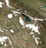
Lake Sevan
Lake Sevan is the largest lake in Armenia and the Caucasus region. It is one of the largest high-altitude lakes in the world.Lake Sevan is situated in the central part of the Republic of Armenia, inside the Gegharkunik Province, at the altitude of 1,900m above sea level...
and Azerbaijan, then passes roughly along the Armenian-Azerbaijani border to Iran. Thus situated, the mountains make travel from north to south difficult. Geological turmoil continues in the form of devastating earthquakes, which have plagued Armenia. In December 1988, the second largest city in the republic, Leninakan (now Gyumri
Gyumri
Gyumri is the capital and largest city of the Shirak Province in northwest Armenia. It is located about 120 km from the capital Yerevan, and, with a population of 168,918 , is the second-largest city in Armenia.The name of the city has been changed many times in history...
), was heavily damaged by a massive quake that killed more than 25,000 people.
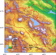
About half of Armenia's area of approximately 29800 square kilometres (11,505.8 sq mi) has an elevation of at least 2000 metres (6,562 ft), and only 3 % of the country lies below 650 metres (2,133 ft). The lowest points are in the valleys of the Araks River and the Debet River in the far north, which have elevations of 380 and 430 m (1,246.7 and 1,410.8 ft), respectively. Elevations in the Lesser Caucasus vary between 2640 and 3280 m (8,661.4 and 10,761.2 ft). To the southwest of the range is the Armenian Plateau, which slopes southwestward toward the Araks River on the Turkish border. The plateau is masked by intermediate mountain ranges and extinct volcanoes. The largest of these, Mount Aragats
Mount Aragats
Mount Aragats , Alagoz - is a large andesitic-to-dacitic stratovolcano in NW Armenia about 40 km NW of the capital city of Yerevan. It is the highest point in Armenia, located in the province of Aragatsotn, northwest from Yerevan. Located on its slopes are the Byurakan Observatory and the...
, 4430 metres (14,534 ft) high, is also the highest point in Armenia. Most of the population lives in the western and northwestern parts of the country, where the two major cities, Yerevan
Yerevan
Yerevan is the capital and largest city of Armenia and one of the world's oldest continuously-inhabited cities. Situated along the Hrazdan River, Yerevan is the administrative, cultural, and industrial center of the country...
and Gyumri (which was called Aleksandropol' during the tsarist period), are located.
The valleys of the Debet and Akstafa rivers form the chief routes into Armenia from the north as they pass through the mountains. Lake Sevan, 72.5 kilometres (45 mi) across at its widest point and 376 kilometres (233.6 mi) long, is by far the largest lake. It lies 2070 metres (6,791 ft) above sea level on the plateau. Terrain is most rugged in the extreme southeast, which is drained by the Bargushat River, and most moderate in the Araks River valley to the extreme southwest. Most of Armenia is drained by the Araks or its tributary, the Hrazdan
Hrazdan
Hrazdan is the capital of the Kotayk province of Armenia. The name Hrazdan is derived from the Middle-Persian name Frazdan. Farzdan is connected to the Zoroastrian mythology. With a population of 52,900 it is the fifth-largest city in Armenia by population. It has lost significant population since...
, which flows from Lake Sevan. The Araks forms most of Armenia's border with Turkey and Iran while the Zangezur Mountains
Zangezur Mountains
The Zangezur Mountains comprise a mountain range that defines the border between Armenia's southern province of Syunik and Azerbaijan's Nakhichevan Autonomous Republic. The second largest tracts of forests in Armenia are located in the Zangezur Mountains where they cover more than 20% of the...
form the border between Armenia's southern province of Syunik
Syunik
Syunik is the southernmost province of Armenia. It borders the Vayots Dzor marz to the north, Azerbaijan's Nakhchivan exclave to the west, Karabakh to the east, and Iran to the south. Its capital is Kapan. Other important cities and towns include Goris, Sisian, Meghri, Agarak, and Dastakert...
and Azerbaijan's adjacent Nakhchivan Autonomous Republic.
Climate
Temperatures in Armenia generally depend upon elevation. Mountain formations block the moderating climatic influences of the Mediterranean Sea and the Black Sea, creating wide seasonal variations. On the Armenian Plateau, the mean midwinter temperature is 0 °C (32 °F), and the mean midsummer temperature exceeds 25 °C (77 °F). Average precipitation ranges from 250 millimetres (9.8 in) per year in the lower Araks River valley to 800 millimetres (31.5 in) at the highest altitudes. Despite the harshness of winter in most parts, the fertility of the plateau's volcanic soil made Armenia one of the world's earliest sites of agricultural activity.Environmental Problems
A broad public discussion of environmental problems began in the mid-1980s, when the first "green" groups formed in opposition to Yerevan's intense industrial air pollution and to nuclear power generation in the wake of the 1986 reactor explosion at Chernobyl'. Environmental issues helped form the basis of the nationalist independence movement when environmental demonstrations subsequently merged with those for other political causes in the late 1980s.In the postcommunist era, Armenia faces the same massive environmental cleanup that confronts the other former Soviet republics as they emerge from the centralized planning system's disastrous approach to resource management. By 1980 the infrequency of sightings of Mount Ararat, which looms about sixty kilometers across the Turkish border, became a symbol of worsening air pollution in Yerevan.
In independent Armenia, environmental issues divide society (and scientists) sharply into those who fear "environmental time bombs" and those who view resumption of pollution-prone industrial operations as the only means of improving the country's economy. In the early 1990s, the latter group blamed Armenia's economic woes on the role played by the former in closing major industries.
In 1994 three national environmental laws were in effect: the Law on Environmental Protection, the Basic Law on the Environment, and the Law on Mineral Resources. The Council of Ministers, Armenia's cabinet, includes a minister of the environment. However, no comprehensive environmental protection program has emerged, and decisions on environmental policy have been made on an ad hoc basis.
Environmental conditions in Armenia have been worsened as a result of war with Azerbaijan over Armenia's claim of historic rights to Azerbaijan's [Nagorno-Karabakh] province. Hostilities along Armenian-Azerbaijan border disrupted crucial supply routes which Armenia was greatly dependent on. The winters of 1991-92, 1992–93, and 1993-94 brought enormous hardship to a population lacking heat and electric power. (The large-scale felling of trees for fuel during the winters has created another environmental crisis.) During these years, Armenia occupied some 20% of Azerbaijan's territory, rendering possibility of supplies from Azerbaijan an impossibility. This led the government to propose reconstruction of the Armenian Atomic Power Station at Metsamor, which was closed after the 1988 earthquake because of its location in an earthquake-prone area and which had the same safety problems as reactors listed as dangerous in Bulgaria, Russia, and Slovakia. After heated debates over startup continued through 1993, French and Russian nuclear consultants declared operating conditions basically safe. Continuation of the blockade into 1994 gave added urgency to the decision.
Another environmental concern is a significant drop in Lake Sevan's water level because of drawdowns for irrigation and the diversion of water to hydroelectric plants to compensate for the electric power lost through the inactivity of the nuclear plant at Metsamor. This crisis was addressed in 1992-93 by construction of a tunnel to divert water into the lake from the Arpa River. Engineers estimated that once the project is finished, the tunnel will allow 500 million cubic meters of water to be drawn from the lake annually, while maintaining a constant water level. The Ministry of the Environment reported that the lake's water level had dropped by fifty centimeters in 1993. Experts said that this drop brought the level to within twenty-seven centimeters of the critical point where flora and fauna would be endangered.
Among major industrial centers closed to curtail pollution were the Nairit Chemical Plant, the Alaverdy Metallurgical Plant, and the Vanadzor Chemical Combine. Economic requirements triumphed over environmental considerations when the Soviet-era Nairit plant was reopened in January 1992 after being closed in 1989 because of the massive air pollution it caused. Newly independent Armenia needed the income from foreign sales of Nairit rubber and chemical products, many of which had been assigned exclusively to that plant under the Soviet system and were still unavailable elsewhere to the former Soviet republics in the early 1990s. Up-to-date environmental safety technology and adherence to international standards were promised at Nairit when the decision to resume production was announced.
Natural hazards:
occasionally severe earthquakes; droughts
Environment - current issues:
soil pollution from toxic chemicals such as DDT; energy blockade, the result of conflict with Azerbaijan, has led to deforestation when citizens scavenged for firewood; pollution of Hrazdan (Razdan) and Araks Rivers; the draining of Sevana Lich (Lake Sevan), a result of its use as a source for hydropower, threatens drinking water supplies; restart of Metsamor nuclear power plant without adequate (IAEA-recommended) safety and backup systems
Environment - international agreements:
party to:
Air Pollution
Air pollution
Air pollution is the introduction of chemicals, particulate matter, or biological materials that cause harm or discomfort to humans or other living organisms, or cause damage to the natural environment or built environment, into the atmosphere....
, Biodiversity
Biodiversity
Biodiversity is the degree of variation of life forms within a given ecosystem, biome, or an entire planet. Biodiversity is a measure of the health of ecosystems. Biodiversity is in part a function of climate. In terrestrial habitats, tropical regions are typically rich whereas polar regions...
, Climate Change
United Nations Framework Convention on Climate Change
The United Nations Framework Convention on Climate Change is an international environmental treaty produced at the United Nations Conference on Environment and Development , informally known as the Earth Summit, held in Rio de Janeiro from June 3 to 14, 1992...
, Climate-Change-Kyoto-Protocol, Desertification
Desertification
Desertification is the degradation of land in drylands. Caused by a variety of factors, such as climate change and human activities, desertification is one of the most significant global environmental problems.-Definitions:...
, Environmental Modification, Hazardous Wastes, Law of the Sea
Law of the sea
Law of the sea may refer to:* United Nations Convention on the Law of the Sea* Admiralty law* The Custom of the Sea...
, Nuclear Test Ban (not into force), Ozone Layer Protection, Wetlands
signed, but not ratified:
Air Pollution-Persistent Organic Pollutants
Area and boundaries
Area:total: 29,743 km²
- country comparison to the world: 149
land: 28,454 km²
water: 1,289 km²
Area comparative
- AustraliaAustraliaAustralia , officially the Commonwealth of Australia, is a country in the Southern Hemisphere comprising the mainland of the Australian continent, the island of Tasmania, and numerous smaller islands in the Indian and Pacific Oceans. It is the world's sixth-largest country by total area...
comparative: about one third (33%) the size of TasmaniaTasmaniaTasmania is an Australian island and state. It is south of the continent, separated by Bass Strait. The state includes the island of Tasmania—the 26th largest island in the world—and the surrounding islands. The state has a population of 507,626 , of whom almost half reside in the greater Hobart... - CanadaCanadaCanada is a North American country consisting of ten provinces and three territories. Located in the northern part of the continent, it extends from the Atlantic Ocean in the east to the Pacific Ocean in the west, and northward into the Arctic Ocean...
comparative: greater than half (56%) the size of Nova ScotiaNova ScotiaNova Scotia is one of Canada's three Maritime provinces and is the most populous province in Atlantic Canada. The name of the province is Latin for "New Scotland," but "Nova Scotia" is the recognized, English-language name of the province. The provincial capital is Halifax. Nova Scotia is the... - United KingdomUnited KingdomThe United Kingdom of Great Britain and Northern IrelandIn the United Kingdom and Dependencies, other languages have been officially recognised as legitimate autochthonous languages under the European Charter for Regional or Minority Languages...
comparative: about one third larger (30%) than WalesWalesWales is a country that is part of the United Kingdom and the island of Great Britain, bordered by England to its east and the Atlantic Ocean and Irish Sea to its west. It has a population of three million, and a total area of 20,779 km²... - United StatesUnited StatesThe United States of America is a federal constitutional republic comprising fifty states and a federal district...
comparative: slightly smaller (7%) than MarylandMarylandMaryland is a U.S. state located in the Mid Atlantic region of the United States, bordering Virginia, West Virginia, and the District of Columbia to its south and west; Pennsylvania to its north; and Delaware to its east... - EU comparative: slightly smaller (8%) than BelgiumBelgiumBelgium , officially the Kingdom of Belgium, is a federal state in Western Europe. It is a founding member of the European Union and hosts the EU's headquarters, and those of several other major international organisations such as NATO.Belgium is also a member of, or affiliated to, many...
Land boundaries:
total: 1,254 km
border countries:
Azerbaijan
Azerbaijan
Azerbaijan , officially the Republic of Azerbaijan is the largest country in the Caucasus region of Eurasia. Located at the crossroads of Western Asia and Eastern Europe, it is bounded by the Caspian Sea to the east, Russia to the north, Georgia to the northwest, Armenia to the west, and Iran to...
and Nagorno-Karabakh Republic
Nagorno-Karabakh Republic
The Nagorno-Karabakh Republic , or Artsakh Republic is a de facto independent republic located in the South Caucasus region of Eurasia...
-proper 566 km, Azerbaijan-Nakhchivan exclave 221 km, Georgia
Georgia (country)
Georgia is a sovereign state in the Caucasus region of Eurasia. Located at the crossroads of Western Asia and Eastern Europe, it is bounded to the west by the Black Sea, to the north by Russia, to the southwest by Turkey, to the south by Armenia, and to the southeast by Azerbaijan. The capital of...
164 km, Iran
Iran
Iran , officially the Islamic Republic of Iran , is a country in Southern and Western Asia. The name "Iran" has been in use natively since the Sassanian era and came into use internationally in 1935, before which the country was known to the Western world as Persia...
35 km, Turkey
Turkey
Turkey , known officially as the Republic of Turkey , is a Eurasian country located in Western Asia and in East Thrace in Southeastern Europe...
268 km
Coastline:
0 km (landlocked)
Maritime claims:
none (landlocked)
Elevation extremes:
lowest point:
Debed River 400 m
highest point:
Mount Aragats
Mount Aragats
Mount Aragats , Alagoz - is a large andesitic-to-dacitic stratovolcano in NW Armenia about 40 km NW of the capital city of Yerevan. It is the highest point in Armenia, located in the province of Aragatsotn, northwest from Yerevan. Located on its slopes are the Byurakan Observatory and the...
4,095 m
Extreme points of Armenia:
North:
Tavush
Tavush
Tavush is a province of Armenia. The marz of Tavush is located in the north of Armenia and borders on Georgia and Azerbaijan.It is well known for its mountains. The most part of its territory is situated 800-1,000 m above sea level...
(41°17′N 45°0′E)
South:
Syunik' (38°49′N 46°10′E)
West:
Shirak (41°5′N 43°27′E)
East:
Syunik' (39°13′N 46°37′E)
Resources and land use
Natural resources:small deposits of gold
Gold
Gold is a chemical element with the symbol Au and an atomic number of 79. Gold is a dense, soft, shiny, malleable and ductile metal. Pure gold has a bright yellow color and luster traditionally considered attractive, which it maintains without oxidizing in air or water. Chemically, gold is a...
, copper
Copper
Copper is a chemical element with the symbol Cu and atomic number 29. It is a ductile metal with very high thermal and electrical conductivity. Pure copper is soft and malleable; an exposed surface has a reddish-orange tarnish...
, molybdenum
Molybdenum
Molybdenum , is a Group 6 chemical element with the symbol Mo and atomic number 42. The name is from Neo-Latin Molybdaenum, from Ancient Greek , meaning lead, itself proposed as a loanword from Anatolian Luvian and Lydian languages, since its ores were confused with lead ores...
, zinc
Zinc
Zinc , or spelter , is a metallic chemical element; it has the symbol Zn and atomic number 30. It is the first element in group 12 of the periodic table. Zinc is, in some respects, chemically similar to magnesium, because its ion is of similar size and its only common oxidation state is +2...
, bauxite
Bauxite
Bauxite is an aluminium ore and is the main source of aluminium. This form of rock consists mostly of the minerals gibbsite Al3, boehmite γ-AlO, and diaspore α-AlO, in a mixture with the two iron oxides goethite and hematite, the clay mineral kaolinite, and small amounts of anatase TiO2...
Land use:
arable land:
16.78%
permanent crops:
2.01%
other:
81.21% (2005)
Irrigated land:
2,860 km² (2003 est.)
Total renewable water resources:
10.5 m³ (1997)
Freshwater withdrawal (domestic/industrial/agricultural):
total: 2.95 km³/yr (30%/4%/66%)
per capita: 977 m³/yr (2000)
Geography Other
landlocked in the Lesser Caucasus Mountains; Sevana Lich (Lake SevanLake Sevan
Lake Sevan is the largest lake in Armenia and the Caucasus region. It is one of the largest high-altitude lakes in the world.Lake Sevan is situated in the central part of the Republic of Armenia, inside the Gegharkunik Province, at the altitude of 1,900m above sea level...
) is the largest lake in this mountain range
See also
- Geography of EuropeGeography of EuropeEurope is traditionally reckoned as one of seven continents. Physiographically, however, it is the northwestern peninsula of the larger landmass known as Eurasia : Asia occupies the eastern bulk of this continuous landmass and all share a common continental shelf...
- Geographical Issues in ArmeniaGeographical Issues in ArmeniaArmenia, a former republic of Soviet Union, is a landlocked country in the Caucasus Mountains between the Black Sea and the Caspian Sea. The country is bordered on the north by Georgia and Iran to the south; Azerbaijan lies to the east and Turkey to the west....
- Mountains of ArmeniaMountains of Armeniathumb|right|A view of [[Mount Aragats]].Armenia a land of rugged mountains and extinct volcanoes, its highest point is Mount Aragats, 13,435 ft .-Mountain ranges:# Javakheti mountain range# Armeno-Georgian mountain range...
- Shikahogh State PreserveShikahogh State PreserveShikahogh State Preserve is Armenia’s second largest forest reserve, covering some 100 km² of land, and located in southern Armenia in the Syunik Province...