

Aberdeen micropolitan area
Encyclopedia
United States Census Bureau
The United States Census Bureau is the government agency that is responsible for the United States Census. It also gathers other national demographic and economic data...
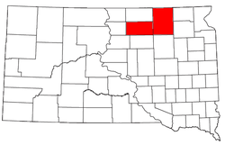
, is an area consisting of two counties in South Dakota
South Dakota
South Dakota is a state located in the Midwestern region of the United States. It is named after the Lakota and Dakota Sioux American Indian tribes. Once a part of Dakota Territory, South Dakota became a state on November 2, 1889. The state has an area of and an estimated population of just over...
, anchored by the city of Aberdeen
Aberdeen, South Dakota
Aberdeen is a city in and the county seat of Brown County, South Dakota, United States, about 125 mi northeast of Pierre. Settled in 1880, it was incorporated in 1882. The city population was 26,091 at the 2010 census. The American News is the local newspaper...
. As of the 2000 census
United States Census, 2000
The Twenty-second United States Census, known as Census 2000 and conducted by the Census Bureau, determined the resident population of the United States on April 1, 2000, to be 281,421,906, an increase of 13.2% over the 248,709,873 persons enumerated during the 1990 Census...
, the μSA had a population of 39,827 (though a July 1, 2009 estimate placed the population at 39,139).
Communities
- Places with more than 30,000 inhabitants
- AberdeenAberdeen, South DakotaAberdeen is a city in and the county seat of Brown County, South Dakota, United States, about 125 mi northeast of Pierre. Settled in 1880, it was incorporated in 1882. The city population was 26,091 at the 2010 census. The American News is the local newspaper...
(Principal city)
- Aberdeen
- Places with 500 to 1,500 inhabitants
- BowdleBowdle, South DakotaBowdle is a city in Edmunds County, South Dakota, United States. The population was 502 at the 2010 census.-Geography:Bowdle is located at ....
- GrotonGroton, South DakotaGroton is a city in Brown County, South Dakota, United States. The population was 1,458 at the 2010 census.-Geography:Groton is located at ....
- IpswichIpswich, South DakotaIpswich is a city in Edmunds County, South Dakota, United States. The population was 954 at the 2010 census. It is the county seat of Edmunds County.-Geography:Ipswich is located at ....
- Bowdle
- Places with 250 to 500 inhabitants
- FrederickFrederick, South DakotaFrederick is a town in Brown County, South Dakota, United States. The population was 199 at the 2010 census. Home to the annual Frederick Finn Fest, the town is part of the Aberdeen Micropolitan Statistical Area.-History:...
- HeclaHecla, South DakotaHecla is a city in Brown County, South Dakota, United States, located only a few miles south of the North Dakota border. The population was 227 at the 2010 census...
- HosmerHosmer, South DakotaHosmer is a city in Edmunds County, South Dakota, United States. The population was 208 at the 2010 census.Hosmer was founded by Russian citizens of German descent. They settled shortly after the townsite of Hosmer was platted by a surveyor for the Chicago, Milwaukee, St. Paul & Pacific Railroad....
- RoscoeRoscoe, South DakotaRoscoe is a city in Edmunds County, South Dakota in the United States. The population was 329 at the 2010 census.-Geography:Roscoe is located at ....
- WarnerWarner, South DakotaWarner is a town in Brown County, South Dakota, United States. The population was 457 at the 2010 census.-Geography:Warner is located at .According to the United States Census Bureau, the town has a total area of , all of it land....
- Frederick
- Places with less than 250 inhabitants
- ClaremontClaremont, South DakotaClaremont is a town in Brown County, South Dakota, United States. The population was 127 at the 2010 census.-Geography:Claremont is located at ....
- ColumbiaColumbia, South DakotaColumbia is a city in Brown County, South Dakota, United States. The population was 136 at the 2010 census.-Geography:Columbia is located at ....
- StratfordStratford, South DakotaStratford is a town in Brown County, South Dakota, United States. The population was 72 at the 2010 census.-Geography:Stratford is located at ....
- VerdonVerdon, South DakotaVerdon is a town in Brown County, South Dakota, United States. The population was 5 at the 2010 census.- Geography :Verdon is located at .According to the United States Census Bureau, the town has a total area of , all of it land....
- WestportWestport, South DakotaWestport is a town in Brown County, South Dakota, United States. The population was 133 at the 2010 census.-Geography:Westport is located at ....
- Claremont
- Unincorporated places
- BarnardBarnard, South DakotaBarnard is an unincorporated community in Brown County, South Dakota, United States. Although not tracked by the Census Bureau, Barnard has been assigned the ZIP Code of 57426....
- BathBath, South DakotaBath is an unincorporated community in Brown County, South Dakota, United States. Although not tracked by the Census Bureau, Bath has been assigned the ZIP code of 57427....
- Beebe
- Craven
- FerneyFerney, South DakotaFerney is an unincorporated community in Brown County, South Dakota, United States. Although not tracked by the Census Bureau, Ferney has been assigned the ZIP code of 57439....
- Gretna
- HoughtonHoughton, South DakotaHoughton is an unincorporated community in Brown County, South Dakota, United States. Although not tracked by the Census Bureau, Houghton has been assigned the ZIP code of 57449.-Notable natives:...
- Huffton
- James
- Loyalton
- MansfieldMansfield, South DakotaMansfield is an unincorporated community in Brown County, South Dakota, United States. The population was 93 according to the 2010 census. Located just west of highway 281, it is approximately 18 miles south of Aberdeen, the third largest city in South Dakota. The James River Valley near which...
- Mina
- Ordway
- Powell
- Randolph
- Richmond
- Barnard
Demographics
As of the censusCensus
A census is the procedure of systematically acquiring and recording information about the members of a given population. It is a regularly occurring and official count of a particular population. The term is used mostly in connection with national population and housing censuses; other common...
of 2000, there were 39,827 people, 16,319 households, and 10,534 families residing within the μSA. The racial makeup of the μSA was 95.88% White, 0.26% African American, 2.45% Native American, 0.37% Asian, 0.08% Pacific Islander, 0.16% from other races
Race (United States Census)
Race and ethnicity in the United States Census, as defined by the Federal Office of Management and Budget and the United States Census Bureau, are self-identification data items in which residents choose the race or races with which they most closely identify, and indicate whether or not they are...
, and 0.80% from two or more races. Hispanic or Latino of any race were 0.65% of the population.
The median income for a household in the μSA was $33,611, and the median income for a family was $40,981. Males had a median income of $28,101 versus $19,263 for females. The per capita income
Per capita income
Per capita income or income per person is a measure of mean income within an economic aggregate, such as a country or city. It is calculated by taking a measure of all sources of income in the aggregate and dividing it by the total population...
for the μSA was $17,307.