

Abbot Ice Shelf
Encyclopedia
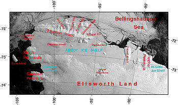
Ice shelf
An ice shelf is a thick, floating platform of ice that forms where a glacier or ice sheet flows down to a coastline and onto the ocean surface. Ice shelves are only found in Antarctica, Greenland and Canada. The boundary between the floating ice shelf and the grounded ice that feeds it is called...
250 mi (402.3 km) long and 40 mile wide, bordering Eights Coast
Eights Coast
Eights Coast is that portion of the coast of West Antarctica between Cape Waite and Pfrogner Point. To the west is Walgreen Coast of Marie Byrd Land, and to the east is Bryan Coast. It is part of Ellsworth Land and stretches between 103°24'W and 89°35'W. This coast is bordered by Thurston Island,...
from Cape Waite
Cape Waite
Cape Waite is a cape at the northwest extremity of King Peninsula, marking the southwest side of the entrance to Peacock Sound. Delineated from air photos taken by U.S. Navy Operation Highjump in December 1946. Named by Advisory Committee on Antarctic Names for Amory H...
to Phrogner Point in Antarctica. Thurston Island
Thurston Island
Thurston Island is an ice-covered, glacially dissected island, long, wide and in area, lying a short way off the NW end of Ellsworth Land, Antarctica. It is the third largest island of Antarctica, after Alexander Island and Berkner Island...
lies along the northern edge of the western half of this ice shelf; other sizable islands (Sherman, Carpenter, Dustin
Dustin Island
Dustin Island is an island about 29 km long, lying 24 km southeast of Cape Annawan, Thurston Island. The feature forms the SE limit of Seraph Bay....
, Johnson
Johnson Island (Antarctica)
Johnson Island is an ice-covered island, about 9 nautical miles long and 5 nautical miles wide, lying within Abbot Ice Shelf, about 14 nautical miles southeast of Dustin Island. The feature was observed and roughly positioned as an "ice rise" by parties from the USS Glacier in February 1961...
, McNamara
McNamara Island
McNamara Island is a mainly ice-covered island, 6 nautical miles long, which is partly within the north edge of Abbot Ice Shelf, about 20 nautical miles east of Dustin Island. Discovered by R. Admiral Byrd and members of the United States Antarctic Service on flights from the Bear, February 27,...
, Farwell
Farwell Island
Farwell Island is an ice-covered island, about 38 nautical miles long and 10 nautical miles wide, lying between McNamara and Dendtler Islands in the east part of Abbot Ice Shelf. The feature was positioned by parties from the USS Glacier and Staten Island in February 1961, and was mapped by...
and Dendtler
Dendtler Island
Dendtler Island is an ice-covered island, 14 nautical miles long, lying in the east part of Abbot Ice Shelf between Farwell Island and Fletcher Peninsula. Mapped by United States Geological Survey from surveys and U.S. Navy air photos, 1960-66. Named by Advisory Committee on Antarctic Names for...
) lie partly or wholly within this shelf.
The ice shelf was sighted by members of U.S. Antarctic Service (USAS) in flights from the ship Bear, in February 1940, and its western portion was delineated from air photos taken by U.S. Navy (USN) Operation Highjump
Operation Highjump
Operation Highjump , officially titled The United States Navy Antarctic Developments Program, 1946-1947, was a United States Navy operation organized by RADM Richard E. Byrd Jr. USN, , Officer in Charge, Task Force 68, and led by RADM Richard H. Cruzen, USN, Commanding Officer, Task Force 68....
, 1946–47. The full extent was mapped by USGS
United States Geological Survey
The United States Geological Survey is a scientific agency of the United States government. The scientists of the USGS study the landscape of the United States, its natural resources, and the natural hazards that threaten it. The organization has four major science disciplines, concerning biology,...
from USN air photos of 1966. Named by US-ACAN
Advisory Committee on Antarctic Names
The Advisory Committee on Antarctic Names is an advisory committee of the United States Board on Geographic Names responsible for recommending names for features in Antarctica...
for Rear Admiral J. Lloyd Abbot, Jr., Commanding Officer, U.S. Naval Support Force, Antarctica, February 1967 to June 1969.