

Aaron Arrowsmith
Encyclopedia
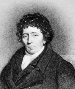
Aaron Arrowsmith was an English cartographer, engraver and publisher and founding member of the Arrowsmith family of geographers. He moved to Soho Square
Soho Square
Soho Square is a square in Soho, London, England, with a park and garden area at its centre that dates back to 1681. It was originally called King Square after Charles II, whose statue stands in the square. At the centre of the garden, there is a distinctive half-timbered gardener's hut...
, London from Winston, County Durham
Winston, County Durham
Winston is a village in County Durham, England. It is situated a few miles to the west of Darlington.The nearby bridge over the River Tees also once held claim to being the biggest single stone arch bridge in Europe....
when about twenty years of age, and was employed by John Cary
John Cary
John Cary was an 18th century English cartographer.Cary served his apprenticeship as an engraver in London, before setting up his own business in the Strand in 1783...
, the engraver and William Faden. He became Hydrographer to the Prince of Wales ca. 1810 and subsequently to the King in 1820. In January 1790 he made himself famous by his large chart of the world on Mercator projection
Mercator projection
The Mercator projection is a cylindrical map projection presented by the Belgian geographer and cartographer Gerardus Mercator, in 1569. It became the standard map projection for nautical purposes because of its ability to represent lines of constant course, known as rhumb lines or loxodromes, as...
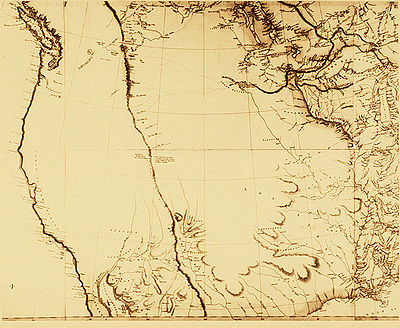
. Four years later he published another large map of the world on the globular projection, with a companion volume of explanation. The maps of North America (1796) and Scotland
Scotland
Scotland is a country that is part of the United Kingdom. Occupying the northern third of the island of Great Britain, it shares a border with England to the south and is bounded by the North Sea to the east, the Atlantic Ocean to the north and west, and the North Channel and Irish Sea to the...
(1807) are the most celebrated of his many later productions. He left two sons, Aaron and Samuel, the elder of whom was the compiler of the Eton Comparative Atlas, of a Biblical atlas, and of various manuals of geography.
The business was thus carried on in company with John Arrowsmith
John Arrowsmith (cartographer)
John Arrowsmith was an English geographer and member of the Arrowsmith family of geographers. He was born at Winston, County Durham....
(1790–1873), nephew of the elder Aaron. In 1821, they published a more complete North American map from a combination of a maps obtained from the Hudson's Bay Company
Hudson's Bay Company
The Hudson's Bay Company , abbreviated HBC, or "The Bay" is the oldest commercial corporation in North America and one of the oldest in the world. A fur trading business for much of its existence, today Hudson's Bay Company owns and operates retail stores throughout Canada...
and Aaron's previous one.
Mount Arrowsmith
Mount Arrowsmith
Mount Arrowsmith is the largest mountain on southern Vancouver Island. Its dominant rock is basalt. The mountain is contained within a UNESCO Biosphere Reserve and as of September 18, 2009 is designated part of 1,300 hectare Mt. Arrowsmith Regional Park....
, situated east of Port Alberni on Vancouver Island
Vancouver Island
Vancouver Island is a large island in British Columbia, Canada. It is one of several North American locations named after George Vancouver, the British Royal Navy officer who explored the Pacific Northwest coast of North America between 1791 and 1794...
, British Columbia, is named for Aaron Arrowsmith and his nephew John Arrowsmith
John Arrowsmith (cartographer)
John Arrowsmith was an English geographer and member of the Arrowsmith family of geographers. He was born at Winston, County Durham....
.
Maps published
- Chart of the world on Mercator's projection, exhibiting all the new discoveries to the present time: with the tracks of the most distinguished navigators since the year 1700, carefully collected from the best charts, maps, voyages, &c extant. , 1790 (8 sheets)
- A Map Exhibiting All the New Discoveries in the Interior Parts of North America, 1 January 1795 (Other editions 1801, 1802, 1804 and 1816 featuring roads)
- Chart of the South PacificPacific OceanThe Pacific Ocean is the largest of the Earth's oceanic divisions. It extends from the Arctic in the north to the Southern Ocean in the south, bounded by Asia and Australia in the west, and the Americas in the east.At 165.2 million square kilometres in area, this largest division of the World...
, 1798 - A New Map of Africa, 1802
- Chart Of The West Indies And Spanish Dominions In North America, 1803 (4 sheets)
- A New Map of Mexico and Adjacent Provinces Compiled from Original Documents., 1810 (4 sheets)
- Map of Countries Round the North Pole, 1818
- Ogden map (North America), 1821 (2nd edition : 1834)