
_motorway_(northern_ireland).gif)
A8(M) motorway (Northern Ireland)
Encyclopedia
The A8 is a motorway in County Antrim
, Northern Ireland
. It is 1 mile (1.6 km) long and is a spur of the M2 motorway
. It was opened on 24 October 1966 and built at the same time as the M2 section to which it connects. It is part of the unsigned European routes E01
and E18
.
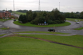
The A8(M) does not meet any other motorways directly, with one end connecting to the A8, and the other connecting to the A6
. The roundabout
junction which links the A8(M) to the M2 is the A6.
Although both sides of the road are the same width, the northbound direction has three lanes, one of which is only partly open to traffic, while southbound only has two. Despite being one of the shortest motorways in Northern Ireland, it still includes matrix displays
and is classified as a separate road, unlike other similar spurs, such as the Walton Summit motorway spur of the M65 motorway
, which are classified as parts of other motorways.
. Part of this alignment became the A8(M) when in 1964 further plans changed the route of the M2 via Antrim to Coleraine
, away from its original direct alignment over difficult terrain
, which is how the plans for construction were then progressed. This road was already under construction at Newtownabbey
, so it was left as a spur.
This section was renamed the A8(M) as it links to the A8 continuing as an A-road
all the way to Larne
.
County Antrim
County Antrim is one of six counties that form Northern Ireland, situated in the north-east of the island of Ireland. Adjoined to the north-east shore of Lough Neagh, the county covers an area of 2,844 km², with a population of approximately 616,000...
, Northern Ireland
Northern Ireland
Northern Ireland is one of the four countries of the United Kingdom. Situated in the north-east of the island of Ireland, it shares a border with the Republic of Ireland to the south and west...
. It is 1 mile (1.6 km) long and is a spur of the M2 motorway
M2 motorway (Northern Ireland)
The M2 is a motorway in Belfast and County Antrim in Northern Ireland. It is in two sections, the southern section running from north Belfast to Antrim and the northern section acts as a bypass of Ballymena, with the A26 road linking the two sections. In total it is 22 miles...
. It was opened on 24 October 1966 and built at the same time as the M2 section to which it connects. It is part of the unsigned European routes E01
European route E01
The European route E 01 is a series of roads in Europe, part of the United Nations International E-road network, running from Larne, Northern Ireland to Seville, Spain. There is a sea crossing between Rosslare Harbour, in Ireland, and Ferrol, but no ferry service...
and E18
European route E18
European route E18 runs from Craigavon in the United Kingdom to Saint Petersburg in Russia, passing through Norway, Sweden, and Finland. It is about 1,890 km in length.-United Kingdom:...
.
The A8(M) does not meet any other motorways directly, with one end connecting to the A8, and the other connecting to the A6
A6 road (Northern Ireland)
The A6 road in Northern Ireland runs from the Belfast to Derry, via Antrim. Mostly single carriageway, there is a short dual carriageway section forming the Toome bypass. Towards Derry, there is also a short section of dual carriageway at Altnagelvin. This is one of Northern Ireland's most...
. The roundabout
Roundabout
A roundabout is the name for a road junction in which traffic moves in one direction around a central island. The word dates from the early 20th century. Roundabouts are common in many countries around the world...
junction which links the A8(M) to the M2 is the A6.
Although both sides of the road are the same width, the northbound direction has three lanes, one of which is only partly open to traffic, while southbound only has two. Despite being one of the shortest motorways in Northern Ireland, it still includes matrix displays
Variable message sign
A variable- message sign, often abbreviated VMS, CMS, or DMS, and in the UK known as a matrix sign,...
and is classified as a separate road, unlike other similar spurs, such as the Walton Summit motorway spur of the M65 motorway
M65 motorway
The M65 is a motorway in Lancashire, England. It runs from just south of Preston through the major junction of the M6 and M61 motorways, east past Darwen, Blackburn, Accrington, Burnley, Nelson and ends at Colne.-History:...
, which are classified as parts of other motorways.
History
In 1956 proposals for several motorways, including the M2, were announced with the M2 running directly to BallymenaBallymena
Ballymena is a large town in County Antrim, Northern Ireland and the seat of Ballymena Borough Council. Ballymena had a population of 28,717 people in the 2001 Census....
. Part of this alignment became the A8(M) when in 1964 further plans changed the route of the M2 via Antrim to Coleraine
Coleraine
Coleraine is a large town near the mouth of the River Bann in County Londonderry, Northern Ireland. It is northwest of Belfast and east of Derry, both of which are linked by major roads and railway connections...
, away from its original direct alignment over difficult terrain
Terrain
Terrain, or land relief, is the vertical and horizontal dimension of land surface. When relief is described underwater, the term bathymetry is used...
, which is how the plans for construction were then progressed. This road was already under construction at Newtownabbey
Newtownabbey
Newtownabbey is a large town north of Belfast in County Antrim, Northern Ireland. Sometimes considered to be a suburb of Belfast, it is separated from the rest of the city by Cavehill and Fortwilliam golf course...
, so it was left as a spur.
This section was renamed the A8(M) as it links to the A8 continuing as an A-road
Great Britain road numbering scheme
The Great Britain road numbering scheme is a numbering scheme used to classify and identify all roads in Great Britain. Each road is given a single letter, which represents the road's category, and a subsequent number, with a length of between 1 and 4 digits. Originally introduced to arrange...
all the way to Larne
Larne
Larne is a substantial seaport and industrial market town on the east coast of County Antrim, Northern Ireland with a population of 18,228 people in the 2001 Census. As of 2011, there are about 31,000 residents in the greater Larne area. It has been used as a seaport for over 1,000 years, and is...
.
Junctions
| A8(M) Motorway | ||
| Northbound exits | Junction | Southbound exits |
| Larne A8 Ballyclare Ballyclare Ballyclare is a small town in County Antrim, Northern Ireland. It had a population of 8,770 people in the 2001 Census... , Newtownabbey B56 |
J1 Terminus |
Start of motorway |
| Start of motorway | M2 J4 Terminus |
Belfast, Dublin M2 Antrim, Mallusk A6 Newtonabbey B90 |
External links
- CBRD
- The Motorway Database - A8(M)
- Northern Ireland film (QuickTimeQuickTimeQuickTime is an extensible proprietary multimedia framework developed by Apple Inc., capable of handling various formats of digital video, picture, sound, panoramic images, and interactivity. The classic version of QuickTime is available for Windows XP and later, as well as Mac OS X Leopard and...
)
- Northern Ireland Roads Site - A8(M)
- The Motorway Archive - M2 (Northern Ireland)
- Pathetic Motorways: A8(M)