
A2212 road
Encyclopedia
London
London is the capital city of :England and the :United Kingdom, the largest metropolitan area in the United Kingdom, and the largest urban zone in the European Union by most measures. Located on the River Thames, London has been a major settlement for two millennia, its history going back to its...
, England
England
England is a country that is part of the United Kingdom. It shares land borders with Scotland to the north and Wales to the west; the Irish Sea is to the north west, the Celtic Sea to the south west, with the North Sea to the east and the English Channel to the south separating it from continental...
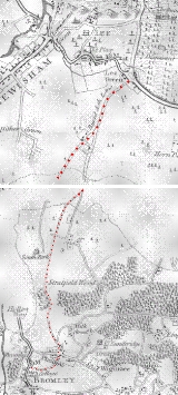
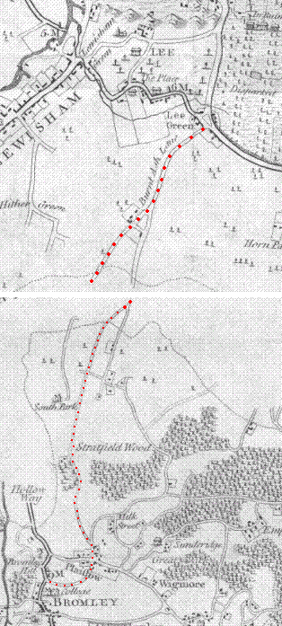
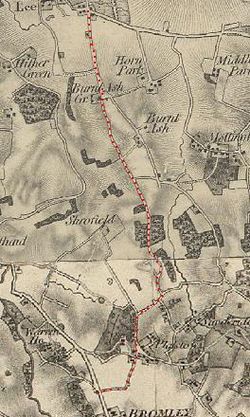
; it is 5.7 km (3.5 mi) long and runs in a north to south direction from Lee Green, to Bromley
Bromley
Bromley is a large suburban town in south east London, England and the administrative headquarters of the London Borough of Bromley. It was historically a market town, and prior to 1963 was in the county of Kent and formed the administrative centre of the Municipal Borough of Bromley...
passing through Grove Park, Downham
Downham
Downham is a district located in south-east London, occupying much of the boundary between the London Borough of Lewisham and the London Borough of Bromley; it is the name of an electoral ward covering much of the area on the Lewisham side...
, Plaistow
Plaistow, Bromley
Plaistow is a locality in the London Borough of Bromley, bordered by the London Borough of Lewisham to the north. It is within the Bromley post town and the BR postcode area....
and Sundridge
Sundridge, Bromley
Sundridge is situated in the north of the London Borough of Bromley, in the ward of Plaistow and Sundridge. Sundridge is south of Grove Park in the London Borough of Lewisham. On the west side of Sundridge is Downham is for the most part in the BR postcode area.The district contains Sundridge Park...
. Bromley is the only one of these places which is a primary destination.
The road begins at Lee Green cross roads coming off the A20 road, ends in Bromley joining the A21 road, and is crossed by the A205 road
A205 road
The A205 or South Circular Road is a direct route which crosses South London, UK, running from Woolwich in the east to the junction of the A406 , the M4 and the A4 at Gunnersbury in the west....
about 1.2 km (0.745647283979768 mi) south of Lee Green. Grove Park traffic lights are approximately the mid point of the road about 2.8 km (1.7 mi) from both Bromley and Lee Green.
In total the road has eight names in different places, approximately half the length of the road has "Burnt Ash" used within its name. From north to south the different names are:
- Burnt Ash Road
- Burnt Ash Hill
- Baring Road
- Burnt Ash Lane
- (Plaistow Green Roundabout)
- Nichol Lane
- College Road
- Cambridge Road
- Paxton Road
- College Road
The road is in two London boroughs and two postcode districts
UK postcodes
The postal codes used in the United Kingdom are known as postcodes. They are alphanumeric and were introduced by the Royal Mail over a 15-year period from 11th October 1959 to 1974...
. At the northern end 3.4 km of the route called Burnt Ash Hill, Burnt Ash Road and Baring Road, is within the London Borough of Lewisham
London Borough of Lewisham
The London Borough of Lewisham is a London borough in south-east London, England and forms part of Inner London. The principal settlement of the borough is Lewisham...
and the postcode district. At the southern end 2.3 km of the route, Burnt Ash Lane, College Road and Plaistow Green roundabout are within the London Borough of Bromley and the postcode district.
London buses
There are two bus stationBus station
A bus station is a structure where city or intercity buses stop to pick up and drop off passengers. It is larger than a bus stop, which is usually simply a place on the roadside, where buses can stop...
s close to the A2212 road. Grove Park bus station on the west side of Baring Road in Grove Park north of the traffic lights. Bromley North bus station is on station road in Bromley alongside Bromley North railway station
Bromley North railway station
Bromley North railway station is in the London Borough of Bromley in south-east London, in Travelcard Zone 4. The station and all trains serving it are operated by Southeastern. It is the terminus of the short Bromley North Branch Line from Grove Park....
about
150 m (500 ft) east of College Road traffic lights the southern end of the A2212 road.
The following London buses
London Buses
London Buses is the subsidiary of Transport for London that manages bus services within Greater London, UK. Buses are required to carry similar red colour schemes and conform to the same fare scheme...
travel along parts of the A2212.
124
London Buses route 124
London Buses route 124 is a Transport for London contracted bus route in London, United Kingdom. The service is currently contracted to Stagecoach London.-History:...
126 136 181 202 261 273 284 314 336 N136
The 261 bus uses the whole length of the road, on its route from Lewisham
Lewisham
Lewisham is a district in South London, England, located in the London Borough of Lewisham. It is situated south-east of Charing Cross. The area is identified in the London Plan as one of 35 major centres in Greater London.-History:...
through Lee and Grove Park to Bromley or Locksbottom
Locksbottom
Locksbottom is a place in the London Borough of Bromley in London, England.It consists of a parade of shops on Crofton Road running from the Fantail to Tugmutton Common. At one end is the Black Horse pub and the Whyte Lion pub at the other...
. The 202 bus uses Burnt Ash Road and Burnt Ash Hill the northern part of the A2212 on its route from Blackheath
Blackheath, London
Blackheath is a district of South London, England. It is named from the large open public grassland which separates it from Greenwich to the north and Lewisham to the west...
through Lee and Hither Green
Hither Green
Hither Green is a district in south east London, England, located in the London Borough of Lewisham. It is situated 6.6 miles south east of Charing Cross, and on the Prime Meridian....
to Catford
Catford
Catford is a district in south London, England, located in the London Borough of Lewisham. It is situated south-east of Charing Cross. The area is identified in the London Plan as one of 35 major centres in Greater London.-Architecture:...
. The 273 bus journey joins the road twice on Burnt Ash Hill and Baring Road using smaller side roads in between on its route from Lewisham through Hither Green, Lee, Grove Park, Chinbrook
Chinbrook
Chinbrook is a suburb in southeast London; it is located southeast of Charing Cross and is in the southeast corner of the London Borough of Lewisham on its boundary with the London Borough of Bromley...
, Mottingham
Mottingham
Mottingham is a district of south London, England; located at the convergence of the London Borough of Bromley, the London Borough of Lewisham and the London Borough of Greenwich...
, Chislehurst
Chislehurst
Chislehurst is a suburban district in south-east London, England, and an electoral ward of the London Borough of Bromley. It is south-east of Charing Cross.-Toponymy:...
to Petts Wood
Petts Wood
-History:The name appeared first in 1577 as "the wood of the Pett family", who were shipbuilders and leased the wood as a source of timbers. William Willett, a campaigner for daylight saving time, lived in nearby Chislehurst for most of his life, and is commemorated by a memorial sundial in the...
. The 126 bus uses the southern half of the A2212, Burnt Ash Lane and College Road on its route from Eltham
Eltham, London
-Parks and open spaces:There is a large variety of open green space in Eltham, in the form of parkland, fields and woodland.*Avery Hill Park is large, open parkland, situated to the east of Eltham. It is most notable for its Winter Garden, a hothouse containing tropical trees and plants from around...
through Mottingham, Chinbrook, Grove Park, Plaistow, and Sundridge to Bromley; part its route is identical to part of the 261 bus route. The buses 314 and 336 use College Road the southern most part of the A2212 between Plaistow Green and Bromley. The buses 124, 181, 273, 284 and N36 stop at Grove Park bus station and use a small part of Baring Road there. There are also several other buses that stop at both ends of the A2212 at Lee Green and Bromley that do not use the road, and the 160 bus travels along the A205 road and stops at its junction with the A2212.
| Section | Buses |
|---|---|
| Lee Green to St. Mildreds Road (A205) | 202, 261, 273 |
| St. Mildreds Road (A205) to Grove Park | 261, 273 |
| Baring Road, Grove Park | 124 London Buses route 124 London Buses route 124 is a Transport for London contracted bus route in London, United Kingdom. The service is currently contracted to Stagecoach London.-History:... , 126, 136, 181, 261, 273, 284, N36 |
| Grove Park to Plaistow Green | 126, 261 |
| Plaistow Green to Bromley | 126, 261, 314, 336 |
Railway transport
There are four railway stations and three railway lines near the A2212 road. LeeLee railway station
Lee station is a suburban railway station on Burnt Ash Hill in Lee in south-east London, England, between Hither Green and Mottingham on the Dartford loop . It was opened by the South Eastern Railway in 1866...
and Grove park
Grove Park railway station
Grove Park railway station is a railway station in London, England. It is located on Baring Road within Travelcard Zone 4, and serves the areas of Grove Park and Downham in the London borough of Lewisham. The station was opened in 1871. Currently there are five platforms...
railway stations have their main entrance on the road while those of Sundridge Park
Sundridge Park railway station
Sundridge Park railway station is in the London Borough of Bromley in south-east London, in Travelcard Zone 4. The station, and all trains serving it, is operated by Southeastern.-Location:...
and Bromley North stations are both within 200 m of it; all four stations are located east of the road. Lee station the northern most of these stations is on the Dartford loop line, here the A2212 passes under a railway bridge where the A2212's name changes from Burnt Ash Road to the north and Burnt Ash Hill to the South. Grove Park station is at the mid point of the A2212 and is on the Southeast Main Line and the Bromley North Line.
Coordinates
Coordinates of junctions- Lee Green (A2212 - A20 junction): 51.4565°N 0.0115°E
- St. Mildreds Road (A2212 - A205 junction): 51.4462°N 0.0142°E
- Grove Park: 51.4313°N 0.0210°E
- Plaistow Green: 51.4145°N 0.0178°E
- Bromley (A2212 - A21 junction): 51.4090°N 0.0142°E