
A' Mharconaich
Encyclopedia
Scotland
Scotland is a country that is part of the United Kingdom. Occupying the northern third of the island of Great Britain, it shares a border with England to the south and is bounded by the North Sea to the east, the Atlantic Ocean to the north and west, and the North Channel and Irish Sea to the...
mountain that is located 29 km WNW of Blair Atholl
Blair Atholl
Blair Atholl is a small town in Perthshire, Scotland, built about the confluence of the Rivers Tilt and Garry in one of the few areas of flat land in the midst of the Grampian Mountains. The Gaelic place-name Blair, from blàr, 'field, plain', refers to this location...
in the Highland
Highland (council area)
Highland is a council area in the Scottish Highlands and is the largest local government area in both Scotland and the United Kingdom as a whole. It shares borders with the council areas of Moray, Aberdeenshire, Perth and Kinross, and Argyll and Bute. Their councils, and those of Angus and...
council area. It is in a group of mountains that lie west of the A9 road near the summit of the Pass of Drumochter
Pass of Drumochter
The Pass of Drumochter is the main mountain pass between the northern and southern central Scottish Highlands. The A9 road passes through here, as does the Highland Main Line, the railway between Inverness and the south of Scotland...
and are known accordingly as the Drumochter Hills. The hill is just within the Cairngorms National Park
Cairngorms National Park
The Cairngorms National Park is a national park in north east Scotland, established in 2003. It was the second of two national parks established by the Scottish Parliament, after Loch Lomond and the Trossachs National Park, set up in 2002. The park covers the Cairngorms range of mountains, and...
although it is not part of the Cairngorms
Cairngorms
The Cairngorms are a mountain range in the eastern Highlands of Scotland closely associated with the mountain of the same name - Cairn Gorm.-Name:...
mountains.
Overview
A' Mharconaich reaches a height of 975 metres (3199 feet) and is the 182nd highest MunroMunro
A Munro is a mountain in Scotland with a height over . They are named after Sir Hugh Munro, 4th Baronet , who produced the first list of such hills, known as Munros Tables, in 1891. A Munro top is a summit over 3,000 ft which is not regarded as a separate mountain...
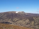
, it is well seen by travellers on the A9 to which it shows it more steeper and rugged eastern flanks with a high corrie
Cirque
Cirque may refer to:* Cirque, a geological formation* Makhtesh, an erosional landform found in the Negev desert of Israel and Sinai of Egypt*Cirque , an album by Biosphere* Cirque Corporation, a company that makes touchpads...
located just beneath the summit. The mountains names translates from the Gaelic
Scottish Gaelic language
Scottish Gaelic is a Celtic language native to Scotland. A member of the Goidelic branch of the Celtic languages, Scottish Gaelic, like Modern Irish and Manx, developed out of Middle Irish, and thus descends ultimately from Primitive Irish....
as "the horse place" and dates from a time when horses were a valuable element of the economy of the region: places where horses gathered would be noted and named accordingly. The hill is crossed by the border between Perth and Kinross
Perth and Kinross
Perth and Kinross is one of 32 council areas in Scotland, and a Lieutenancy Area. It borders onto the Aberdeenshire, Angus, Dundee City, Fife, Clackmannanshire, Stirling, Argyll and Bute and Highland council areas. Perth is the administrative centre...
and Highland areas or in the old day Perthshire
Perthshire
Perthshire, officially the County of Perth , is a registration county in central Scotland. It extends from Strathmore in the east, to the Pass of Drumochter in the north, Rannoch Moor and Ben Lui in the west, and Aberfoyle in the south...
and Inverness-shire
Inverness-shire
The County of Inverness or Inverness-shire was a general purpose county of Scotland, with the burgh of Inverness as the county town, until 1975, when, under the Local Government Act 1973, the county area was divided between the two-tier Highland region and the unitary Western Isles. The Highland...
and is marked by old rusting fence posts which can be used as an aid to navigation when traversing the hill.
Geography
A' Mharconaich has a SW-NE orientated summit ridge, just over a kilometre long with high points at each end. The NE summit is regarded as the highest point although there is very little difference in height with both having a 970 metre ring contour. In 1974 the SE top, named Bruach nan Iomairean, was deemed to be the summit of the mountain when the Munro tables were revised by the SMCScottish Mountaineering Club
The Scottish Mountaineering Club is Scotland's second oldest mountaineering club. Founded in 1889, in Glasgow, the private club, with about 400 members, publishes guidebooks and runs a list of Munroists.-History:At the time of the club's founding there were a number of experienced Alpinists...
, however the decision was reversed in 1981. A' Mharconaich throws out two fine steep ridges on either side of the eastern corrie. The NE ridge descends initially as a steep buttress before easing and continuing for three km to reach the A9 at Balsporran Cottages.
The less well defined eastern ridge descends steeply from Bruach nan Iomairean to a col
Mountain pass
A mountain pass is a route through a mountain range or over a ridge. If following the lowest possible route, a pass is locally the highest point on that route...
with a height of approximately 655 metres which links to the hill the Boar of Badenoch also known as An Torc. The line of old fence posts can be followed the whole way. The Boar reaches a height of 739 metres and though it is usually regarded as a separate hill from A' Mharconaich it does not qualify for any hill lists
Hill lists in the British Isles
The mountains and hills of Great Britain, and to a lesser extent Ireland, are the subject of a considerable number of lists that categorise them by height, topographic prominence, or other criteria. They are commonly used as a basis for peak bagging, whereby hillwalkers attempt to reach all the...
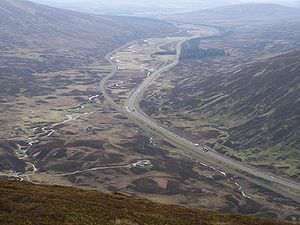
and could be regarded as its eastern outlier. It is a fine viewpoint down into the Pass of Drumochter.
To the SW A' Mharconaich links to the adjacent Munro of Beinn Udlamain
Beinn Udlamain
Beinn Udlamain is a Scottish mountain which stands just to the west of the summit of the Pass of Drumochter and east of Loch Ericht, some 30 km west-northwest of the village of Blair Atholl. The mountain’s summit stands on the border between the Highland and Perth and Kinross council...
, again following the fence posts for four km across undulating ground with little loss of height. This area is often teeming with deer being part of the Dalnaspidal deer forest. 2.5 km to the north is another Munro, Geal-chàrn which is reached by descending to a height of 739 metres and traversing around the head of Coire Fhar. Drainage from A' Mharconaich reaches the east coast of Scotland but is divided by the Pass of Drumochter, either going north to join the River Spey
River Spey
The River Spey is a river in the northeast of Scotland, the second longest and the fastest-flowing river in Scotland...
or south to meet the River Tay
River Tay
The River Tay is the longest river in Scotland and the seventh-longest in the United Kingdom. The Tay originates in western Scotland on the slopes of Ben Lui , then flows easterly across the Highlands, through Loch Dochhart, Loch Lubhair and Loch Tay, then continues east through Strathtay , in...
.
Ascents and view
There are two starting points for the direct ascent of A' Mharconaich and several permutations if it is being climbed in conjunction with other hills as it usually is. One route starts on the A9 at the top of the Pass of Drumochter at grid reference and goes up Coire Dhomhain for just over a kilometre and then ascending NW to the col between A' Mharconaich and the Boar of Badenoch from where the line of fence posts is followed steeply to the summit ridge. This starting point can be used for a complete circuit of Coire Dhomhain taking in the other two Munros of Sgairneach MhòrSgairneach Mhòr
Sgairneach Mhòr is a Scottish mountain which lies in a group of seven Munros near the summit of the Pass of Drumochter and are known as the Drumochter mountains or informerly as the “A9 Munros”...
and Beinn Udlamain.
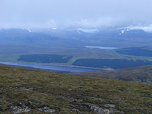
An alternative start is at Balsporran cottages , and offers a direct ascent up the NE ridge or a longer walk which takes in the adjoining Munro of Geal-chàrn. The summit is marked by a substantial collection of stones which has been shaped in to a wind shelter rather than the usual cairn. The view includes Loch Ericht
Loch Ericht
Loch Ericht is a freshwater loch on the border between Perth and Kinross and the Highlands Council areas of Scotland. It is situated at a height of 351 metres above sea level and has a north-east to south-west orientation. The village of Dalwhinnie lies at the north east end of the loch...
and Loch Pattack to the NW and the Ben Alder
Ben Alder
Ben Alder is the highest mountain in the remote area of the Scottish Highlands between Loch Ericht and Glen Spean. The vast summit plateau is home of one of Britain's highest bodies of standing water, Lochan a' Garbh Coire. It is the 25th highest Munro, and due to its remote location, one of the...
massif.