
A' Bhuidheanach Bheag
Encyclopedia
A' Bhuidheanach Bheag is a Scottish
mountain situated on the eastern side of the Pass of Drumochter
, some 24 km WNW of Blair Atholl
. The mountain straddles the border between Highland
and Perth and Kinross
council areas although the actual summit is in the latter.
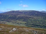
s which draws many walkers to the locale. A' Bhuidheanach Bheag lies to the southern end of the plateau and when viewed from the A9 road it shows many shallow ravines and gullies. The actual summit is out of sight from the A9 being sited back from the edge of the plateau. The rolling nature of the terrain makes A' Bhuidheanach Bheag a good hill for ski mountaineering
.
Despite its understated reputation A' Bhuidheanach Bheag does offer the walker the feeling of space and the wide open skies of the high Grampian mountains. Its gentle curving slopes have much wildlife with Eurasian Dotterel
, Ptarmigan, Grouse
and Mountain Hare
seen on a regular basis. The hill's name translates from the Gaelic
language as “Little Yellow Place” and is thought to refer to the coarse yellow grass which grows on its slopes. The “Little” part of the name is slightly confusing as the hill is the highest point on the southern part of the plateau but demonstrates that the hill was named from how it looked from the valley not by its altitude.
on the eastern side of the mountain. This is a steep sided valley which cuts deeply into the hill and is drained by the Allt a’ Chama Choire. The coire is well seen from the hill of An Dun above the Gaick Pass. From a geological point of view the most interesting characteristic of the mountain is Coire Mhic-sith on its south-western flank. The coire is a deeply incised, fault-guided valley which has received the attention of geologists, especially the School of Geoscience at the University of Edinburgh
who have concluded that the presence of glacial silt and sand in the valley along with a glacial spillway to the adjacent valley of the Edendon Water means that the coire had a large ice dammed lake during the last Ice age
. This Proglacial lake
drained away when the ice melted but has left evidence similar, but on a lesser scale, to the “parallel roads” in Glen Roy
.
The summit of the mountain is a gentle rise on the plateau and is only made obvious by the presence of an OS
trig point
. There are occasional quartzite outcrops across the summit plateau and some of the boulders have been collected to surround the trig point, a few iron fence post have also been included. The OS
map also shows a 936 metre spot height, half a kilometre to the west of the recognised summit. The summit is crossed by a line of old rusting boundary fence posts and these lead unerringly to the adjoining Munro of Càrn na Caim which lies five km to the north across a boggy col with a height of 825 metres.
A'Bhuidheanach Bheag has two notable subsidiary tops, Glas Mheall Mòr (928 metres) lies just over two km to the ESE and is ranked as a top in the Munro Tables. Another former top from the tables is Meall a' Chaorainn (916 metres) which is located 1.5 km to the west of the summit and was deleted from the tables in 1981. All drainage from the mountain finds its way to the east coast of Scotland, the majority goes south to join the River Tay
while a smaller percentage goes north via Glen Truim to join the River Spey
.
Scotland
Scotland is a country that is part of the United Kingdom. Occupying the northern third of the island of Great Britain, it shares a border with England to the south and is bounded by the North Sea to the east, the Atlantic Ocean to the north and west, and the North Channel and Irish Sea to the...
mountain situated on the eastern side of the Pass of Drumochter
Pass of Drumochter
The Pass of Drumochter is the main mountain pass between the northern and southern central Scottish Highlands. The A9 road passes through here, as does the Highland Main Line, the railway between Inverness and the south of Scotland...
, some 24 km WNW of Blair Atholl
Blair Atholl
Blair Atholl is a small town in Perthshire, Scotland, built about the confluence of the Rivers Tilt and Garry in one of the few areas of flat land in the midst of the Grampian Mountains. The Gaelic place-name Blair, from blàr, 'field, plain', refers to this location...
. The mountain straddles the border between Highland
Highland (council area)
Highland is a council area in the Scottish Highlands and is the largest local government area in both Scotland and the United Kingdom as a whole. It shares borders with the council areas of Moray, Aberdeenshire, Perth and Kinross, and Argyll and Bute. Their councils, and those of Angus and...
and Perth and Kinross
Perth and Kinross
Perth and Kinross is one of 32 council areas in Scotland, and a Lieutenancy Area. It borders onto the Aberdeenshire, Angus, Dundee City, Fife, Clackmannanshire, Stirling, Argyll and Bute and Highland council areas. Perth is the administrative centre...
council areas although the actual summit is in the latter.
Overview
The high ground to the east side of the Pass of Drumochter takes the form of a huge undulating plateau, with an average height of over 800 metres, which stretches NE for 13 km to Loch an t-Seilich in the Gaick Forest. This area is often dismissed as uninteresting countryside, however it does contain two MunroMunro
A Munro is a mountain in Scotland with a height over . They are named after Sir Hugh Munro, 4th Baronet , who produced the first list of such hills, known as Munros Tables, in 1891. A Munro top is a summit over 3,000 ft which is not regarded as a separate mountain...
s which draws many walkers to the locale. A' Bhuidheanach Bheag lies to the southern end of the plateau and when viewed from the A9 road it shows many shallow ravines and gullies. The actual summit is out of sight from the A9 being sited back from the edge of the plateau. The rolling nature of the terrain makes A' Bhuidheanach Bheag a good hill for ski mountaineering
Ski mountaineering
Ski mountaineering is form of ski touring that variously combines the sports of Telemark, Alpine, and backcountry skiing with that of mountaineering...
.
Despite its understated reputation A' Bhuidheanach Bheag does offer the walker the feeling of space and the wide open skies of the high Grampian mountains. Its gentle curving slopes have much wildlife with Eurasian Dotterel
Eurasian Dotterel
The Eurasian Dotterel , or in Europe just Dotterel, is a small wader in the plover family of birds.It breeds in the Arctic tundra of northern Eurasia, from Norway to eastern Siberia, and on suitable mountain plateaus such as the Scottish highlands and the Alps...
, Ptarmigan, Grouse
Grouse
Grouse are a group of birds from the order Galliformes. They are sometimes considered a family Tetraonidae, though the American Ornithologists' Union and many others include grouse as a subfamily Tetraoninae in the family Phasianidae...
and Mountain Hare
Mountain Hare
The Mountain Hare , also known as Blue Hare, Tundra Hare, Variable Hare, White Hare, Alpine Hare and Irish Hare, is a hare, which is largely adapted to polar and mountainous habitats. It is distributed from Fennoscandia to eastern Siberia; in addition there are isolated populations in the Alps,...
seen on a regular basis. The hill's name translates from the Gaelic
Scottish Gaelic language
Scottish Gaelic is a Celtic language native to Scotland. A member of the Goidelic branch of the Celtic languages, Scottish Gaelic, like Modern Irish and Manx, developed out of Middle Irish, and thus descends ultimately from Primitive Irish....
language as “Little Yellow Place” and is thought to refer to the coarse yellow grass which grows on its slopes. The “Little” part of the name is slightly confusing as the hill is the highest point on the southern part of the plateau but demonstrates that the hill was named from how it looked from the valley not by its altitude.
Geography and geology
A' Bhuidheanach Bheag’s best geographical feature is the remote Cama ChoireCirque
Cirque may refer to:* Cirque, a geological formation* Makhtesh, an erosional landform found in the Negev desert of Israel and Sinai of Egypt*Cirque , an album by Biosphere* Cirque Corporation, a company that makes touchpads...
on the eastern side of the mountain. This is a steep sided valley which cuts deeply into the hill and is drained by the Allt a’ Chama Choire. The coire is well seen from the hill of An Dun above the Gaick Pass. From a geological point of view the most interesting characteristic of the mountain is Coire Mhic-sith on its south-western flank. The coire is a deeply incised, fault-guided valley which has received the attention of geologists, especially the School of Geoscience at the University of Edinburgh
University of Edinburgh
The University of Edinburgh, founded in 1583, is a public research university located in Edinburgh, the capital of Scotland, and a UNESCO World Heritage Site. The university is deeply embedded in the fabric of the city, with many of the buildings in the historic Old Town belonging to the university...
who have concluded that the presence of glacial silt and sand in the valley along with a glacial spillway to the adjacent valley of the Edendon Water means that the coire had a large ice dammed lake during the last Ice age
Ice age
An ice age or, more precisely, glacial age, is a generic geological period of long-term reduction in the temperature of the Earth's surface and atmosphere, resulting in the presence or expansion of continental ice sheets, polar ice sheets and alpine glaciers...
. This Proglacial lake
Proglacial lake
In geology, a proglacial lake is a lake formed either by the damming action of a moraine or ice dam during the retreat of a melting glacier, or by meltwater trapped against an ice sheet due to isostatic depression of the crust around the ice...
drained away when the ice melted but has left evidence similar, but on a lesser scale, to the “parallel roads” in Glen Roy
Glen Roy
Glen Roy in the Lochaber area of the Highlands of Scotland is a National Nature Reserve and is noted for the geological puzzle of the three roads ....
.
The summit of the mountain is a gentle rise on the plateau and is only made obvious by the presence of an OS
Ordnance Survey
Ordnance Survey , an executive agency and non-ministerial government department of the Government of the United Kingdom, is the national mapping agency for Great Britain, producing maps of Great Britain , and one of the world's largest producers of maps.The name reflects its creation together with...
trig point
Trig point
A triangulation station, also known as a triangulation pillar, trigonometrical station, trigonometrical point, trig station, trig beacon or trig point, and sometimes informally as a trig, is a fixed surveying station, used in geodetic surveying and other surveying projects in its vicinity...
. There are occasional quartzite outcrops across the summit plateau and some of the boulders have been collected to surround the trig point, a few iron fence post have also been included. The OS
Ordnance Survey
Ordnance Survey , an executive agency and non-ministerial government department of the Government of the United Kingdom, is the national mapping agency for Great Britain, producing maps of Great Britain , and one of the world's largest producers of maps.The name reflects its creation together with...
map also shows a 936 metre spot height, half a kilometre to the west of the recognised summit. The summit is crossed by a line of old rusting boundary fence posts and these lead unerringly to the adjoining Munro of Càrn na Caim which lies five km to the north across a boggy col with a height of 825 metres.
A'Bhuidheanach Bheag has two notable subsidiary tops, Glas Mheall Mòr (928 metres) lies just over two km to the ESE and is ranked as a top in the Munro Tables. Another former top from the tables is Meall a' Chaorainn (916 metres) which is located 1.5 km to the west of the summit and was deleted from the tables in 1981. All drainage from the mountain finds its way to the east coast of Scotland, the majority goes south to join the River Tay
River Tay
The River Tay is the longest river in Scotland and the seventh-longest in the United Kingdom. The Tay originates in western Scotland on the slopes of Ben Lui , then flows easterly across the Highlands, through Loch Dochhart, Loch Lubhair and Loch Tay, then continues east through Strathtay , in...
while a smaller percentage goes north via Glen Truim to join the River Spey
River Spey
The River Spey is a river in the northeast of Scotland, the second longest and the fastest-flowing river in Scotland...
.