

4th Ring Road (Beijing)
Encyclopedia
Beijing
Beijing , also known as Peking , is the capital of the People's Republic of China and one of the most populous cities in the world, with a population of 19,612,368 as of 2010. The city is the country's political, cultural, and educational center, and home to the headquarters for most of China's...
, China
China
Chinese civilization may refer to:* China for more general discussion of the country.* Chinese culture* Greater China, the transnational community of ethnic Chinese.* History of China* Sinosphere, the area historically affected by Chinese culture...
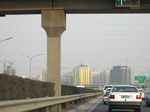
which runs around the city approximately 8 kilometres from the centre of the city.
Although it is the city's third ring road, it is named the 4th Ring Road.
Route
The 4th Ring Road runs within the confines of the city of BeijingBeijing
Beijing , also known as Peking , is the capital of the People's Republic of China and one of the most populous cities in the world, with a population of 19,612,368 as of 2010. The city is the country's political, cultural, and educational center, and home to the headquarters for most of China's...
, more like a rectangle than a circle.
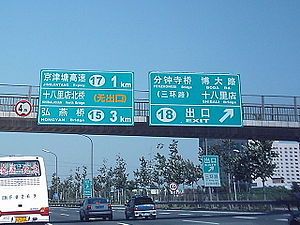
Basic Route: Siyuan Bridge
Siyuan Bridge
thumb|300px|Siyuan Bridge as seen from the [[Airport Expressway |Airport Expressway]].Siyuan Bridge is a large, complex overpass in northeastern Beijing, China....
- Chaoyang Park
Chaoyang Park
Beijing Chaoyang Park is a park located on the site of the former Prince's Palace in Beijing's Chaoyang District.The park's construction began in 1984 with it eventually growing to become Beijing's largest park. It is approximately 2.8 km in length and approximately 1.5 km in width. It has a total...
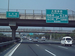
Area - Sihui
Sihui
Sihui , historically known as Szewui, is a county-level city of Guangdong Province, in southern China, under the jurisdiction of Zhaoqing. Population: 80,000....
- Sifang Bridge - Shibalidian
Shibalidian
thumb|300px|The Shibalidian transportational node.Shibalidian is the name of a transportational node in Beijing, China. Flanked by several overpasses, it is where the southeastern 4th Ring Road links with the Jingjintang Expressway...
- Dahongmen - Majialou - Yuegezhuang
Yuegezhuang
Yuegezhuang is a part of the city of Beijing to the southwest.Yuegezhuang is a transportational node; the 4th Ring Road and the Jingshi Expressway interconnect at Yuegezhuang....
Bridge - Fengtai
Fengtai District
Fengtai District is a suburban district of the municipality of Beijing. It lies to the southwest of the urban core of the city.-History:In Qing Dynasty times, Fengtai was where the Imperial Manchu Army had its camps, trained, and held parades on festive occasions.It is 304.2 square kilometers in...
Area - Sijiqing Area - Zhongguancun
Zhongguancun
Zhongguancun , or Zhong Guan Cun, is a technology hub in Haidian District, Beijing, China.It is geographically situated in the northwestern part of Beijing city, in a band between the northwestern Third Ring Road and the northwestern Fourth Ring Road...
Area - Jianxiang - Asian Games Village
Asian Games Village
The Asian Games Village is located in the Siri Fort area, near Hauz Khas in New Delhi, India.The site was developed as the Athlete's Village for the 1982 Asian Games, held in New Delhi. The Village is the first of its kind in the Games series...
Area - Wanghe Bridge
Wanghe Bridge
Wanghe Bridge is an overpass and a nodal point in Beijing.When it was first built it carried a railway line over the northeastern 4th Ring Road. This railway line ran from the now disused Hepingli Railway Station....
- Siyuan Bridge
Siyuan Bridge
thumb|300px|Siyuan Bridge as seen from the [[Airport Expressway |Airport Expressway]].Siyuan Bridge is a large, complex overpass in northeastern Beijing, China....
Status: The entire express road is complete and open to traffic.
History
Already in the early 1990s, the northern stretch of the 4th Ring Road from ZhongguancunZhongguancun
Zhongguancun , or Zhong Guan Cun, is a technology hub in Haidian District, Beijing, China.It is geographically situated in the northwestern part of Beijing city, in a band between the northwestern Third Ring Road and the northwestern Fourth Ring Road...
to Siyuan Bridge
Siyuan Bridge
thumb|300px|Siyuan Bridge as seen from the [[Airport Expressway |Airport Expressway]].Siyuan Bridge is a large, complex overpass in northeastern Beijing, China....
existed as a ring road, albeit with far narrower road conditions and with traffic lights. Only three flyover viaducts—those at Jianxiang, Anhui Bridge and Siyuan Bridge
Siyuan Bridge
thumb|300px|Siyuan Bridge as seen from the [[Airport Expressway |Airport Expressway]].Siyuan Bridge is a large, complex overpass in northeastern Beijing, China....
-- existed.
To commemorate the 50th anniversary of the People's Republic of China
People's Republic of China
China , officially the People's Republic of China , is the most populous country in the world, with over 1.3 billion citizens. Located in East Asia, the country covers approximately 9.6 million square kilometres...
, the eastern stretch of the 4th Ring Road was opened from Siyuan Bridge
Siyuan Bridge
thumb|300px|Siyuan Bridge as seen from the [[Airport Expressway |Airport Expressway]].Siyuan Bridge is a large, complex overpass in northeastern Beijing, China....
to Shibalidian
Shibalidian
thumb|300px|The Shibalidian transportational node.Shibalidian is the name of a transportational node in Beijing, China. Flanked by several overpasses, it is where the southeastern 4th Ring Road links with the Jingjintang Expressway...
around October 1, 1999. This was the first part of the ring road to be opened as an 8-lane expressway (4 lanes per direction, not including an emergency belt).
The northern part of the 4th Ring Road from Jianxiang to Siyuan Bridge
Siyuan Bridge
thumb|300px|Siyuan Bridge as seen from the [[Airport Expressway |Airport Expressway]].Siyuan Bridge is a large, complex overpass in northeastern Beijing, China....
was converted to an 8-lane expressway in late September 2000. Later that year, the southern part from Shibalidian
Shibalidian
thumb|300px|The Shibalidian transportational node.Shibalidian is the name of a transportational node in Beijing, China. Flanked by several overpasses, it is where the southeastern 4th Ring Road links with the Jingjintang Expressway...
through to Fengtai
Fengtai District
Fengtai District is a suburban district of the municipality of Beijing. It lies to the southwest of the urban core of the city.-History:In Qing Dynasty times, Fengtai was where the Imperial Manchu Army had its camps, trained, and held parades on festive occasions.It is 304.2 square kilometers in...
opened to traffic, as was the case with the northwestern part.
By June 2001, the entire 4th Ring Road had been converted into an expressway-standard thoroughfare.
In early 2004, the speed limit was reduced to a unified 80 km/h (minimum speed limit: 50 km/h).
In September 2004, the 4th Ring Road underwent a massive sign change. Exit numberings were unified at last—bidirectionally (this was previously not the case).
A new overpass in the northern stretch was put into operation in October 2004, near the Beichen area.
Speed Limit
Previously: first lane, min. 80 km/h, max. 100 km/h; second lane, min. 70 km/h, max. 90 km/h; third lane, min. 60 km/h, max. 80 km/h; fourth lane, min. 50 km/h, max. 80 km/h; auxiliary road, uniform max. speed limit of 70 km/h. Readjusted in 2004 so that all lanes have a uniform min. speed limit of 50 km/h and a max. speed limit of 80 km/h; aux. road max. speed limit of 70 km/h remains unchanged.Traffic Conditions
The portion from Jianxiang to Siyuan BridgeSiyuan Bridge
thumb|300px|Siyuan Bridge as seen from the [[Airport Expressway |Airport Expressway]].Siyuan Bridge is a large, complex overpass in northeastern Beijing, China....
, in both directions, is especially vulnerable to horrible traffic jams. The remainder of the northern and eastern portions are also vulnerable. Apart from the Fengtai
Fengtai District
Fengtai District is a suburban district of the municipality of Beijing. It lies to the southwest of the urban core of the city.-History:In Qing Dynasty times, Fengtai was where the Imperial Manchu Army had its camps, trained, and held parades on festive occasions.It is 304.2 square kilometers in...
area, the remainder of the 4th Ring Road has a lesser risk of being clogged up by traffic jams.
Major Exits
Siyuan BridgeSiyuan Bridge
thumb|300px|Siyuan Bridge as seen from the [[Airport Expressway |Airport Expressway]].Siyuan Bridge is a large, complex overpass in northeastern Beijing, China....
, Sihui
Sihui
Sihui , historically known as Szewui, is a county-level city of Guangdong Province, in southern China, under the jurisdiction of Zhaoqing. Population: 80,000....
, Sifang Bridge, Shibalidian
Shibalidian
thumb|300px|The Shibalidian transportational node.Shibalidian is the name of a transportational node in Beijing, China. Flanked by several overpasses, it is where the southeastern 4th Ring Road links with the Jingjintang Expressway...
, Majialou, Fengtai
Fengtai District
Fengtai District is a suburban district of the municipality of Beijing. It lies to the southwest of the urban core of the city.-History:In Qing Dynasty times, Fengtai was where the Imperial Manchu Army had its camps, trained, and held parades on festive occasions.It is 304.2 square kilometers in...
, Yuegezhuang
Yuegezhuang
Yuegezhuang is a part of the city of Beijing to the southwest.Yuegezhuang is a transportational node; the 4th Ring Road and the Jingshi Expressway interconnect at Yuegezhuang....
, Zhongguancun
Zhongguancun
Zhongguancun , or Zhong Guan Cun, is a technology hub in Haidian District, Beijing, China.It is geographically situated in the northwestern part of Beijing city, in a band between the northwestern Third Ring Road and the northwestern Fourth Ring Road...
, Jianxiang, Wanghe Bridge
Wanghe Bridge
Wanghe Bridge is an overpass and a nodal point in Beijing.When it was first built it carried a railway line over the northeastern 4th Ring Road. This railway line ran from the now disused Hepingli Railway Station....
.
Service Areas
No full-scale service areas exist; however, filling stations (gas stations) are plentiful in number.Connections
Badaling ExpresswayBadaling Expressway
The Badaling Expressway is an expressway in the People's Republic of China which links urban Beijing to the Badaling stretch of the Great Wall of China...
: Connects to the Badaling Expressway at Jianxiang.
Jingcheng Expressway
Jingcheng Expressway
The Jingcheng Motorway is a motorway in China which links Beijing to Chengde in Hebei province. The total length is 210 kilometres.It is a new motorway linking the northeastern portion of the 3rd Ring Road with the north and northeastern outlying regions of Beijing municipality...
: Connects to the Jingcheng Expressway at Wanghe Bridge
Wanghe Bridge
Wanghe Bridge is an overpass and a nodal point in Beijing.When it was first built it carried a railway line over the northeastern 4th Ring Road. This railway line ran from the now disused Hepingli Railway Station....
(for the time being, only heading for Laiguangying and Chengde
Chengde
Chengde , previously known as Jehol or Re He , is a prefecture-level city in Hebei province, People's Republic of China, situated northeast of Beijing. It is best known as the site of the Mountain Resort, a vast imperial garden and palace formerly used by the Qing emperors as summer residence...
).
Airport Expressway
Airport Expressway (Beijing)
The Airport Expressway is an expressway in Beijing, China, which links central Beijing to the Beijing Capital International Airport...
: Connects to the Airport Expressway at Siyuan Bridge
Siyuan Bridge
thumb|300px|Siyuan Bridge as seen from the [[Airport Expressway |Airport Expressway]].Siyuan Bridge is a large, complex overpass in northeastern Beijing, China....
(only heading for the airport).
Projected Jingping Expressway
Jingping Expressway
The Jingping Expressway is an expressway in Beijing, China, with construction commencing in early 2005.-Construction stages:Construction is expected to follow in early 2005, with a stretch opened by 2006. By 2007, the entire expressway will have been completed in full...
: Would most likely connect at Dongfeng North Bridge.
Jingtong Expressway
Jingtong Expressway
The Jingtong Expressway is an expressway with express road characteristics in Beijing, China which links central Beijing to Tongzhou District...
: Connects to the Jingtong Expressway at Sihui
Sihui
Sihui , historically known as Szewui, is a county-level city of Guangdong Province, in southern China, under the jurisdiction of Zhaoqing. Population: 80,000....
.
Jingshen Expressway
Jingshen Expressway
The Jingshen Expressway is an expressway in China which links Beijing to Shenyang. It is 658 km in length.It leaves Beijing heading east and is numbered G025...
: Connects to the Jingshen Expressway at Sifang Bridge (only heading for Shenyang
Shenyang
Shenyang , or Mukden , is the capital and largest city of Liaoning Province in Northeast China. Currently holding sub-provincial administrative status, the city was once known as Shengjing or Fengtianfu...
).
Jingjintang Expressway
Jingjintang Expressway
Opened in September 1993, the Jingjintang Expressway , also known as the Jingtang Expressway, links Beijing via central Tianjin to the Tanggu District in eastern Tianjin...
: Connects to the Jingjintang Expressway at Shibalidian
Shibalidian
thumb|300px|The Shibalidian transportational node.Shibalidian is the name of a transportational node in Beijing, China. Flanked by several overpasses, it is where the southeastern 4th Ring Road links with the Jingjintang Expressway...
.
Jingkai Expressway
Jingkai Expressway
The Jingkai Expressway is an expressway in China which links Beijing to Kaifeng. At present, it is approximately 40 km in length in the Beijing section....
: Connects to the Jingkai Expressway at Majialou.
Jingshi Expressway
Jingshi Expressway
The Jingshi Expressway is an expressway in China which links Beijing to the Shijiazhuang. It is c. 270 km in length. Its road numbering is G030...
: Connects to the Jingshi Expressway at Yuegezhuang
Yuegezhuang
Yuegezhuang is a part of the city of Beijing to the southwest.Yuegezhuang is a transportational node; the 4th Ring Road and the Jingshi Expressway interconnect at Yuegezhuang....
.
Signs
English language
English is a West Germanic language that arose in the Anglo-Saxon kingdoms of England and spread into what was to become south-east Scotland under the influence of the Anglian medieval kingdom of Northumbria...
on the signs confused drivers, but what was most confusing was the exit numbering. It so happened that the same exit had two different exit numbers -- one for each direction of the ring road.
Beijing authorities had three years' lapse before they dealt with the problem. Old signs were progressively replaced by newer signs which had standardised English and, finally, a new exit numbering system was in place. A sketch map of each exit, formerly only for expressways and isolated spots, was also introduced along with the new sign numbering.
Another change was the use of traffic sign language to signal traffic regulations instead of relying completely on Chinese
Chinese written language
Written Chinese comprises Chinese characters used to represent the Chinese language, and the rules about how they are arranged and punctuated. Chinese characters do not constitute an alphabet or a compact syllabary...
Hanzi. Some bridge names (e.g. Sihe Bridge
Sihe Bridge
Sihe Bridge is a bridge in Beijing.It sits on the southern stretch of the 4th Ring Road.Before the 4th Ring Road signpost change in September 2004, it was named Huaxiang Bridge as it was close to the locality of Huaxiang, which literally means "Flower Village"...
) are also getting a name change at the same time.
The project was somewhat Herculean since 441 signs were to be replaced. Of those, exit and entrance signs formed 202 signs; other, mainly larger-sized signs, formed the remaining 239 signs. Earlier in the summer of 2004, similar measures for the 5th Ring Road (which had an absent-to-chaotic exit numbering system) were announced.
In a show of speed, within the first 100 hours, new exit numberings went up for pretty much all of the western stretch of the 4th Ring Road (despite new/old signs being alternated on a different stretch of the ring road).
Reaction to the new signs are mixed. There is a definitive plus side: the exits are now matched with their equivalent exit/bridge names on the 3rd and 5th
5th Ring Road (Beijing)
Beijing's 5th Ring Road is a ring road encircling the city about 10 kilometres away from the city centre. It takes the form of an expressway and is 98 kilometres in length...
ring roads
Ring Roads of Beijing
Beijing is one of the very few cities to possess multiple ring roads .-1st Ring Road:The 1st Ring Road no longer exists under that name. In the 1920s, around half a dozen routes were established in Beijing for the first tram lines of the city...
. Unfortunately, many complain of an information overkill. Signs are now complex enough to hold five different directions (on some bridges) -- way too much for the eye and brain to digest. Meanwhile, the mixing of lowercase and uppercase English in small font sizes is another concern.
Bad news for speeders: on both the 4th Ring Road and the 5th Ring Road, quite a number of speed traps—cameras—were put into place, along with the general sign change overall.
List of Exits
[Heading in a clockwise direction as of the Northern 4th Ring Road—please note, Exit No. 1 begins at Wanghe BridgeWanghe Bridge
Wanghe Bridge is an overpass and a nodal point in Beijing.When it was first built it carried a railway line over the northeastern 4th Ring Road. This railway line ran from the now disused Hepingli Railway Station....
]
Notes:
- Exits present only in a clockwise direction are indicated by the symbol ↩; anticlockwise only, ↪; not yet open, ✕
- Exit sign symbols: ↗ = exit, ⇆ = interchange with an expressway or China National Highway;
North 4th Ring Road
- ↗ 43: Summer PalaceSummer PalaceThe Summer Palace is a palace in Beijing, China. The Summer Palace is mainly dominated by Longevity Hill and the Kunming Lake. It covers an expanse of 2.9 square kilometers, three quarters of which is water....
, Landianchang North Road (Huoqiying Bridge) - ↗ 44: Wanquanhe Road, Suzhou Bridge
- ↗ 45: Haidian Bridge
- ↗ 46: ZhongguancunZhongguancunZhongguancun , or Zhong Guan Cun, is a technology hub in Haidian District, Beijing, China.It is geographically situated in the northwestern part of Beijing city, in a band between the northwestern Third Ring Road and the northwestern Fourth Ring Road...
, Sitong Bridge - ↗ 47: Xueyuan Road, Jimen Bridge (Xueyuan Bridge)
- ↗ 48: Zhixin East Street, Beitaiping Bridge (Zhixin Bridge)
- ⇆ 49: (Interchange with Badaling ExpresswayBadaling ExpresswayThe Badaling Expressway is an expressway in the People's Republic of China which links urban Beijing to the Badaling stretch of the Great Wall of China...
) Badaling ExpresswayBadaling ExpresswayThe Badaling Expressway is an expressway in the People's Republic of China which links urban Beijing to the Badaling stretch of the Great Wall of China...
(Jianxiang Bridge)- ⇆ 49A: Madian Bridge
- ⇆ 49B: Badaling ExpresswayBadaling ExpresswayThe Badaling Expressway is an expressway in the People's Republic of China which links urban Beijing to the Badaling stretch of the Great Wall of China...
(ChangpingChangping DistrictChangping District , formerly Changping County , is situated in the suburbs of northwest Beijing.Changping District, covering an area of 1,430 square kilometers, has 2 subdistricts of the city of Changping and 15 towns with total population of 614,821...
) - ↗ 49C: Beichen West Road (max. height 3.5 m)
- ↗ 50: Beichen Road, Beichen East Road, Beichen West Road (Beichen Bridge)
- ↗ 51: Anzhen Bridge, Anli Road (Anhui Bridge)
- ↗ 52: Beiyuan Road, Lishuiqiao
- ↗ 53: HepingHepingliHepingli is a residential neighborhood in Dongcheng District, Beijing, China. It is situated in the northeastern part of the city between the northern 2nd Ring Road and the northern 3rd Ring Road. The neighborhood is bordered by Andingmen Waidajie to the west and Hepingli Dongjie to the east. ...
East Bridge, Xiaoying Road (Huixin East Bridge) - ↗ (↩) Yuhui South Street
- ⇆ 1: (Interchange with Jingcheng ExpresswayJingcheng ExpresswayThe Jingcheng Motorway is a motorway in China which links Beijing to Chengde in Hebei province. The total length is 210 kilometres.It is a new motorway linking the northeastern portion of the 3rd Ring Road with the north and northeastern outlying regions of Beijing municipality...
) Jingcheng ExpresswayJingcheng ExpresswayThe Jingcheng Motorway is a motorway in China which links Beijing to Chengde in Hebei province. The total length is 210 kilometres.It is a new motorway linking the northeastern portion of the 3rd Ring Road with the north and northeastern outlying regions of Beijing municipality...
(Wanghe BridgeWanghe BridgeWanghe Bridge is an overpass and a nodal point in Beijing.When it was first built it carried a railway line over the northeastern 4th Ring Road. This railway line ran from the now disused Hepingli Railway Station....
)- ⇆ 1A: 3rd Ring Road ✕
- ⇆ 1B: N. 5th Ring Road, ShunyiShunyi DistrictShunyi District is an administrative district of Beijing, located outside of the city proper.-Overview:...
- ↗ (↪) Jiangzhuanghu
- ↗ 2: WangjingWangjing, BeijingWangjing is a major residential area and subdistrict of Chaoyang District, in the northeast of Beijing, China. The name "Wangjing" means "view of Beijing".- Koreatown :...
West Road - ↗ 3: ✕
- ⇆ 4: (Interchange with the Airport ExpresswayAirport Expressway (Beijing)The Airport Expressway is an expressway in Beijing, China, which links central Beijing to the Beijing Capital International Airport...
and China National Highway 101China National Highway 101China National Highway 101 is a major trunk route in China, which connects Beijing to Shenyang, Liaoning. In Beijing it is known as Jingshun Road or Jingmi Road for connecting central Bejiing to Shunyi District and Miyun County, although the actual road goes far beyond these two locations.It leaves...
) (Siyuan BridgeSiyuan Bridgethumb|300px|Siyuan Bridge as seen from the [[Airport Expressway |Airport Expressway]].Siyuan Bridge is a large, complex overpass in northeastern Beijing, China....
)- ⇆ 4A: Sanyuan Bridge, (↩) Xiaoyun Road
- ⇆ 4B: Jingshun RoadChina National Highway 101China National Highway 101 is a major trunk route in China, which connects Beijing to Shenyang, Liaoning. In Beijing it is known as Jingshun Road or Jingmi Road for connecting central Bejiing to Shunyi District and Miyun County, although the actual road goes far beyond these two locations.It leaves...
(ShunyiShunyi DistrictShunyi District is an administrative district of Beijing, located outside of the city proper.-Overview:...
) - ⇆ 4C: Airport ExpresswayAirport Expressway (Beijing)The Airport Expressway is an expressway in Beijing, China, which links central Beijing to the Beijing Capital International Airport...
East 4th Ring Road
- ↗ 5: (↪) Sanyuan East Bridge, DashanziDashanziDashanzi is a 1 square kilometer area in the Chaoyang district of Beijing, northeast of the city center. It lies along the Airport Expressway between the 4th and 5th Ring Roads, south of the Dashanzi Qiao flyover and opposite Wangjing.Most of the area is made up of an industrial park...
(Xiaoyun Bridge) - ↗ 6: Yansha Bridge, Jiuxianqiao (Dongfeng North Bridge)
- ↗ 7: Yaojiayuan Road, Changhong Bridge (Chaoyuangongyuan Bridge)
- ↗ 8: Changhong Bridge, Chaoyang ParkChaoyang ParkBeijing Chaoyang Park is a park located on the site of the former Prince's Palace in Beijing's Chaoyang District.The park's construction began in 1984 with it eventually growing to become Beijing's largest park. It is approximately 2.8 km in length and approximately 1.5 km in width. It has a total...
, Yaojiayuan Road, Chaoyang North Road (Honglingjin Bridge) - ↗ 9: ✕
- ⇆ 10: (Interchange with Jingtong ExpresswayJingtong ExpresswayThe Jingtong Expressway is an expressway with express road characteristics in Beijing, China which links central Beijing to Tongzhou District...
) Guomao Bridge, Jingtong ExpresswayJingtong ExpresswayThe Jingtong Expressway is an expressway with express road characteristics in Beijing, China which links central Beijing to Tongzhou District...
(SihuiSihuiSihui , historically known as Szewui, is a county-level city of Guangdong Province, in southern China, under the jurisdiction of Zhaoqing. Population: 80,000....
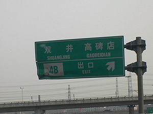
Bridge) - ↗ 11: Shuangjing Bridge, Guangqu Road (Dajiaoting Bridge)
- ↗ 12: Jinsong Bridge, Huagong Road (Yaowahu Bridge)
- ↗ 13: Gongda Bridge
- ⇆ 14: (Interchange with Jingshen ExpresswayJingshen ExpresswayThe Jingshen Expressway is an expressway in China which links Beijing to Shenyang. It is 658 km in length.It leaves Beijing heading east and is numbered G025...
) Jingshen ExpresswayJingshen ExpresswayThe Jingshen Expressway is an expressway in China which links Beijing to Shenyang. It is 658 km in length.It leaves Beijing heading east and is numbered G025...
(bound for 5th Ring Road and BeidaiheBeidaiheBeidaihe District is a district in Qinhuangdao municipality, Hebei province on the coast of the Bohai Sea in North China. It has an area of 70.14 square kilometers and a population of 66,000. is also known as a birding haven. The Beidaihe Beach Resort stretches 10 km from east to west, from...
) - ↗ 15: Hongyan Road, Fatou (Hongyan Bridge)
- ↗ 16: (↪) ShibalidianShibalidianthumb|300px|The Shibalidian transportational node.Shibalidian is the name of a transportational node in Beijing, China. Flanked by several overpasses, it is where the southeastern 4th Ring Road links with the Jingjintang Expressway...
North Bridge - ⇆ 17: (Interchange with Jingjintang ExpresswayJingjintang ExpresswayOpened in September 1993, the Jingjintang Expressway , also known as the Jingtang Expressway, links Beijing via central Tianjin to the Tanggu District in eastern Tianjin...
) Jingjintang ExpresswayJingjintang ExpresswayOpened in September 1993, the Jingjintang Expressway , also known as the Jingtang Expressway, links Beijing via central Tianjin to the Tanggu District in eastern Tianjin...
(bound for 5th Ring Road, TianjinTianjin' is a metropolis in northern China and one of the five national central cities of the People's Republic of China. It is governed as a direct-controlled municipality, one of four such designations, and is, thus, under direct administration of the central government...
) (ShibalidianShibalidianthumb|300px|The Shibalidian transportational node.Shibalidian is the name of a transportational node in Beijing, China. Flanked by several overpasses, it is where the southeastern 4th Ring Road links with the Jingjintang Expressway...
Bridge)
South 4th Ring Road
- ↗ 18: FenzhongsiFenzhongsiFenzhongsi is a transportational node in Beijing.It is the starting point of the Jingjintang Expressway to Langfang, Tianjin and Tanggu.Fenzhongsi lies on the southeastern segment of the 3rd Ring Road....
Bridge, Boda Rd, ShibalidianShibalidianthumb|300px|The Shibalidian transportational node.Shibalidian is the name of a transportational node in Beijing, China. Flanked by several overpasses, it is where the southeastern 4th Ring Road links with the Jingjintang Expressway...
(ShibalidianShibalidianthumb|300px|The Shibalidian transportational node.Shibalidian is the name of a transportational node in Beijing, China. Flanked by several overpasses, it is where the southeastern 4th Ring Road links with the Jingjintang Expressway...
South Bridge) - ↗ 19: (↩) Longzhuashu (Xiaohongmen Bridge)
- ↗ 20: Chengshousi, YizhuangYizhuangYizhuang may refer to two places in China:* Yizhuang, Beijing , area of Daxing District* Yizhuang, Xuzhou , town in Tongshan District, Xuzhou, Jiangsu...
(Xiaocun Bridge) - ↗ 21: (↩) Dahongmen / (↪) Xiaohongmen (Liuxiang Bridge)
- ↗ 22: (↪) Dahongmen, Jiugong (Dahongmen East Bridge)
- ⇆ 23: (Interchange with China National Highway 104China National Highway 104China National Highway 104 runs from Beijing to Fuzhou via Jinan, Xuzhou, Nanjing, Hangzhou and Taizhou.It runs to approximately 2,390 km, and, on a map, runs southeast towards Nanjing and Hangzhou before turning south-southwest at Taizhou....
) Nanyuan Road (G104)China National Highway 104China National Highway 104 runs from Beijing to Fuzhou via Jinan, Xuzhou, Nanjing, Hangzhou and Taizhou.It runs to approximately 2,390 km, and, on a map, runs southeast towards Nanjing and Hangzhou before turning south-southwest at Taizhou....
, Muxiyuan Bridge, Nanyuan Airport (Dahongmen Bridge) - ↗ 24: Wanfang Bridge, Majiapu Road (Gongyi Bridge)
- ↗ 25: Caoqiao
- ⇆ 26: (Interchange with Jingkai ExpresswayJingkai ExpresswayThe Jingkai Expressway is an expressway in China which links Beijing to Kaifeng. At present, it is approximately 40 km in length in the Beijing section....
) Jingkai ExpresswayJingkai ExpresswayThe Jingkai Expressway is an expressway in China which links Beijing to Kaifeng. At present, it is approximately 40 km in length in the Beijing section....
(Majialou Bridge) - ↗ 27: Xinfadi
- ↗ 28: Huaxiang (Sihe BridgeSihe BridgeSihe Bridge is a bridge in Beijing.It sits on the southern stretch of the 4th Ring Road.Before the 4th Ring Road signpost change in September 2004, it was named Huaxiang Bridge as it was close to the locality of Huaxiang, which literally means "Flower Village"...
)
West 4th Ring Road
- ↗ 29: Baiqiang Ave, Beijing World ParkBeijing World ParkBeijing World Park is a theme park that attempts to give visitors the chance to see the world without having to leave Beijing. The park covers 46.7 hectares and is located in the southwestern Fengtai District of Beijing. It is about 17 km from Tiananmen, the City center, and 40 km from...
, Sci-Tech Park (Kandan Bridge) - ↗ 30: Fengtai S Rd, Fufeng Rd, Kexing Rd (Kefeng Bridge)
- ↗ 31: FengtaiFengtai DistrictFengtai District is a suburban district of the municipality of Beijing. It lies to the southwest of the urban core of the city.-History:In Qing Dynasty times, Fengtai was where the Imperial Manchu Army had its camps, trained, and held parades on festive occasions.It is 304.2 square kilometers in...
Town - ↗ 32: (Interchange with Jingshi ExpresswayJingshi ExpresswayThe Jingshi Expressway is an expressway in China which links Beijing to the Shijiazhuang. It is c. 270 km in length. Its road numbering is G030...
) Jingshi ExpresswayJingshi ExpresswayThe Jingshi Expressway is an expressway in China which links Beijing to the Shijiazhuang. It is c. 270 km in length. Its road numbering is G030...
(headed for FangshanFangshan DistrictFangshan District is situated in the southwest of Beijing, 38 km away from the downtown Beijing. It has an area of 2,019 square kilometers and a population of 814,367...
) (road link under construction) (Fengbei Bridge) - ⇆ 33: (Interchange with Jingshi ExpresswayJingshi ExpresswayThe Jingshi Expressway is an expressway in China which links Beijing to the Shijiazhuang. It is c. 270 km in length. Its road numbering is G030...
) Jingshi ExpresswayJingshi ExpresswayThe Jingshi Expressway is an expressway in China which links Beijing to the Shijiazhuang. It is c. 270 km in length. Its road numbering is G030...
(headed for FangshanFangshan DistrictFangshan District is situated in the southwest of Beijing, 38 km away from the downtown Beijing. It has an area of 2,019 square kilometers and a population of 814,367...
) (YuegezhuangYuegezhuangYuegezhuang is a part of the city of Beijing to the southwest.Yuegezhuang is a transportational node; the 4th Ring Road and the Jingshi Expressway interconnect at Yuegezhuang....
Bridge) - ↗ 34: Liuli BridgeLiuliqiaoLiuliqiao is situated on the southwestern stretch of Beijing's 3rd Ring Road."Liu Li Qiao" literally means "Six Li Bridge", where the li refers to a Chinese unit of distance ....
, Zhengchangzhuang - ↗ 35: (Wukesong Bridge)
- ↗ 36: (↩) Yongding Rd, Xicui Rd
- ↗ 37: Fushi Road, Hangtian Bridge (Dinghui Bridge)
- ↗ 38: Wuluju
- ↗ 39: Xingshikou Bridge, Eight Great Sites, Zizhu Bridge (Sijiqing Bridge)
- ↗ 40: (↩) Yuanda Road
- ↗ 41: Xijiao Airport, Landianchang (Nanwu Bridge)
- ↗ 42: Fragrant HillsFragrant HillsFragrant Hills Park is a public park at the foot of the Western Mountains in the Haidian District, in the northwestern part of Beijing, China. It covers 1.6 km² and consists of a natural pine-cypress forest, hills with maple trees, smoke trees and persimmon trees, as well as landscaped areas with...
, Jade Spring Hills (Sihai Bridge)